We have 38° this morning at 6 am which is 10° warmer than we had for a low yesterday morning as we continue with our cool pattern.
We have threats of widespread frost over the next three nights which isn’t typical though not unheard of for early May. Last year at this time we also started out the month of May on a cool note before it warmed into the 70s and 80s, the difference was we had more rain last year. We should be back in the 60s by midweek and near 70 by the weekend.
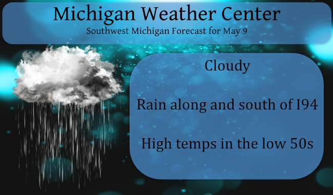
Rain chances diminish as you go north of Kalamazoo today, along I94 and south will be the greater chances. Our next chance of rain won’t be until the end of the week.
Last year we ended May with 6.25 inches of rain most of which fell the second half of the month. We had 12.81 inches for March, April, and May making it a wetter than normal spring. (these are Otsego totals). This year we have had 3.44 inches for the same period.
Forecast Discussion
-- Rain Showers Across Southern Michigan Today --

A surface low moving from eastern MO to southern IN/OH today will
bring a batch of rain into extreme southern Lower MI this morning
and afternoon before ending this evening. SPC HREF 24hr
precipitation indicates rainfall of about 0.50" near and south of I-
94, with a sharp gradient north of I-94 to just a few hundredths a
as you approach the I-96 corridor and little to nothing north of
there. No instability will lead to a zero threat for thunder across
our region.

-- Multiple Frost and Freeze Events Yet to Go --

As has been advertised, the threat for frosts and freezes continues
into mid week. Looking at 850mb temps from a standardized anomaly
perspective, we`re seeing about 2 to 3 standard deviations below
normal through mid week. That`s keeping surface temperatures a good
10 to 15 degrees below normal into Tuesday before we finally
moderate a bit. The highest likelihood for a hard freeze (upper 20s
for at least a few hours) will be interior central Lower MI each of
the next few nights. It appears that most of our fruit belt region
along the lakeshore should escape a hard freeze. However, microscale
terrain features could potentially support upper 20s in certain
areas. Sensitive plants will need to be covered for most areas until
we get past Wednesday morning.

-- Quiet This Week...But Possibly More Active After That --

Other than some spotty diurnal showers Tuesday afternoon courtesy of
an upper low moving through the eastern Great Lakes, this work week
looks pretty quiet. The sub-cloud layer looks quite dry on Tuesday,
so these showers will be fairly minor, though it is worth noting
that wet bulb temps are close to 40F so if a shower does develop,
surface temps may crash while it is precipitating.

It was recently mentioned by WDM that the Madden Julian Oscillation
(MJO) has played a significant role in both the cooler temperatures
we have seen in the last several days (and will continue to see) as
well as the lower than normal precipitation amounts. The MJO was
strongly in Phase 1 and has recently been strong in Phase 2, both of
which have statistical significance in giving us cooler than normal
temperatures. The GEFS forecast brings it into a weak Phase 3, then
more of an incoherent signal before perhaps emerging into Phase 4 or
5 in the next seven to ten days. This is when ensemble guidance
indicates some support for higher precipitable water potential as
well as more typical temperatures for May than we are currently
seeing.
What an incredible cold spell! More freezing temps are coming! Get prepared!
Crazzy I just saw a NFL commercial coming in September then I thought wow September is only 4 months away but then again with no fans last season due to covid-19 they are getting ready excited sooner with fans this season!!! It’s great seeing things getting back to normal again and seeing less and less people wearing mask soon all sporting events will be full again ….INDY ….
We need a lot more people to get vaccinated before we return to normalcy!
Looks like we get a taste of summer soon. CPC maps getting the shades of red again.
Just realized why this month is called May.
It May be 80. It May be 40.
Happy Mother’s Day!
Frost advisory for Grand Rapids tonight middle of May and we have frost advisorys going on wow well way better then heat advisorys lol….INDY
52* degrees in my area well below average day again who knew?? Our cool Spring continues ahhhhhhh….INDY
So far this meteorological spring has been much closer to average than many would think. With a very cool period since mid April off setting a very warm start in March and early April. We will have to see how the rest of May plays out to get the finial outcome.
Slim
Happy mother’s Day!! Lots of weather mom’s out there enjoy your day ….INDY!!
No rain till the end of the week? Ugh, boy it is dry for this time of the year. Boring weather pattern we are in again. However the sun is coming out of its dormant cycle. Very active sunspot turning earthward the next couple of days. https://spaceweather.com/
The month of May is now below average at most locations. And in the last 27 days there have been 22 days below average and only 5 day above average. The over night low here was 37 and at this time with cloudy skies it is 41. It has not only been cool it also has been some what dry. Officially at GRR they have reported 1.04″ of rain in the last 27 days while here at my house I have only recorded 0.78″ of rain fall.
Slim
Wow to the wow 22 days out of the last 27 and still going strong below average I think we can officially say this has been a cool Spring yes hard for a few to say but when slim post the facts come out!! INDY
What are the totals so far for Met Spring? As in how many days above/below since March 1?
Make that 23 days today and 24 days tommorow …..shuuuuu…INDY
Since March 1? Out of 70 days only 24 below? You’re making yourself look bad if that’s the total.
Since March 1st there have been a total of 37 days above average and 33 days below average. Since the calendar start of spring there as been 24 days above average and 26 days below average.
Slim
Again in Slim we trust with the facts! Yes our cool Spring continues thank you Slim ….INDY
Kind of shoots down your theory as 37 days above beats 33 days below.
You answer your own question!! Wow! INDY….
Sorry, no. Scroll up and see that Slim answered my question.