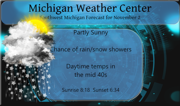
Just about any location in Lower Michigan could see a rain or snow shower pass through over the next couple of days, but it will tend to be more common closer to Lake Michigan. Accumulating snow, at least on the grass, is not out of the question in some locations in western and central Michigan, as has already been happening farther north and in the U.P. where our first winter weather advisories are in place and 2 to 4 inches of snow are possible.
Of course, this is all a teaser for what is to come for the winter months. The snow cover is slowly creeping down to the 45th parallel however the ice cover on the western side of Greenland and in the Hudson Bay is behind schedule so we will have to see how this affects our early winter.
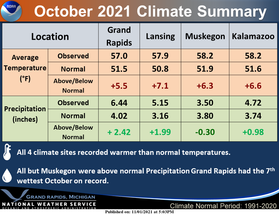
October was generally a quite warm and wet month for most locations across West Michigan. Grand Rapids had the 7th wettest October on record.
Forecast Discussion
-- Lake effect showers through Thursday morning --

As expected, lake effect showers developed Monday evening and
mid-level atmospheric conditions will largely support showers
into Thursday morning. We remain on the poleward side of the upper
level jet with shortwaves moving through the cyclonic flow until
then. Inversion heights and cloud top temperatures will not
always be ideal for lake effect (sometimes dropping below the DGZ)
but most of the time will be good enough for at least a few
showers in the area. There will be a tendency for wet snow to make
it down to the surface especially at night and especially in
areas away from the warm lake. Light coatings of accumulation on
grass are possible as some passing showers could be moderate
intensity.

On the short-term horizon, an uptick in the showers is expected
late this afternoon into the evening with the approach of a
shortwave trough. Initially showers should spread well inland, but
into the night they may tend to become concentrated near and west
of US-131. With temperatures Tuesday night expected to be a
little colder than Monday night, a change to snow should be pretty
common.

-- Moderating temperature trend into next week and likely dry --

With the North American omega block flattening out and Rossby wave
pattern becoming more progressive late in the week, the upper
levels overhead will transition toward ridging and then split
flow, keeping the weather dry. Milder air will start to return on
the back side of the high over the weekend. Currently only a
small minority of ensemble members give us rain over the weekend.
I am depressed by the relentless sun and unseasonable warmth in Southeast Michigan. It’s supposed to jump up to 60 again next week, which will be the second week of November. NOVEMBER. I’ve become someone who loathes summer. I know I sound like a miserable person. Maybe I am. I live for crisp, overcast, autumn days, and super snowy winters. Bring the snow. Yes. Not sure how people can deny the obvious presence of climate change when all anyone over 30 who grew up with four seasons needs to do is remember what Halloween through New Year’s Day looked and… Read more »
Be careful what you wish for – I used to live in Maine – they can have brutal winters.
Its snowing very hard out in my area right now love it …InDY
I love seeing that fantastic four letter word! SNOW!!!!! Rock n Roll baby!
First snow flakes of the season on this beautiful below average day party on or snowy on lol ….InDY
I love it!
Wait till this winter Indy! The warm weather nuts will say it is not a big snowstorm when we are getting pounded with 6 inches of snow! Incredible!
Multiple 60 degree days next week? Get ready!
How could that be??? Bring it!!
The overnight low here at my house was 38, the official overnight low at GRR was 37. There was 0.02″ in the rain gauge. At this time it is partly cloudy and 38 here. While the Maple tree across the street is dropping its leaves most of the trees in my area still have most if not all of their leaves still on them. There are Ash trees that have dropped most of their leaves but that is it. I have trees in my yard that are still green yet.
Slim
Incredibly mild October we had looking at the numbers. The one oddity is Muskegon coming in below average in rainfall while everyone else was well above.
I wonder why the NWS did not mention that it was the 3rd warmest October at Muskegon, Holland and Lansing and the 7th warmest at Grand Rapids. Well I guess I just did.
Slim
Strange that it is early November and my lawn looks better than it has all year.
I was thinking the same thing yesterday. Growing like crazy and the whole yard is a deep, bright green.