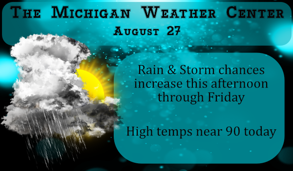
We are now coming into a more active weather pattern which will be a welcome change after the warm dry period we have been experiencing much of the summer. For many areas, this will be the first decent rainfall we have seen since around the 11th. In our area, we have had only three times where it rained an inch or more all summer.
This is the hydrologic outlook for southern Michigan:
...Heavy rain and localized flooding possible over the next few
days...

Heavy rain over the next few days may lead to localized
flooding and ponding of water in urban areas and low spots, as
well as flooding on smaller streams and creeks. The next round of
storms is expected to develop Thursday afternoon and evening, with
another, and likely stronger, round of storms and heavy rain
Friday afternoon/evening. Thunderstorms moving over the same areas
repeatedly have the potential to produce between 1 and 3 inches of
rain in some locations between now and Saturday morning. Because
soils are currently quite dry, we are not expecting significant
runoff to cause any river flooding issues.
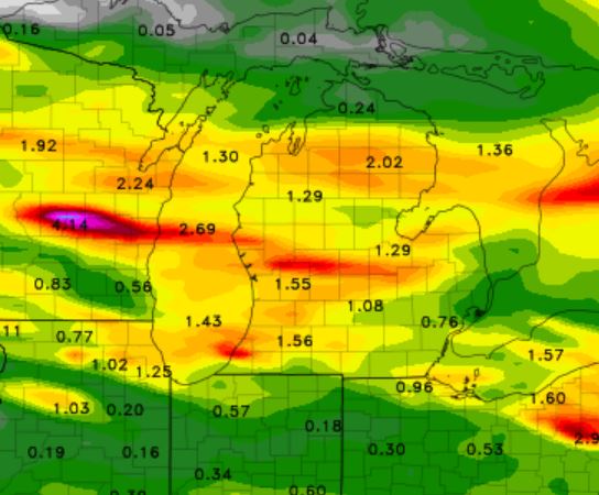
This is the NAM guess at rainfall through Saturday morning:
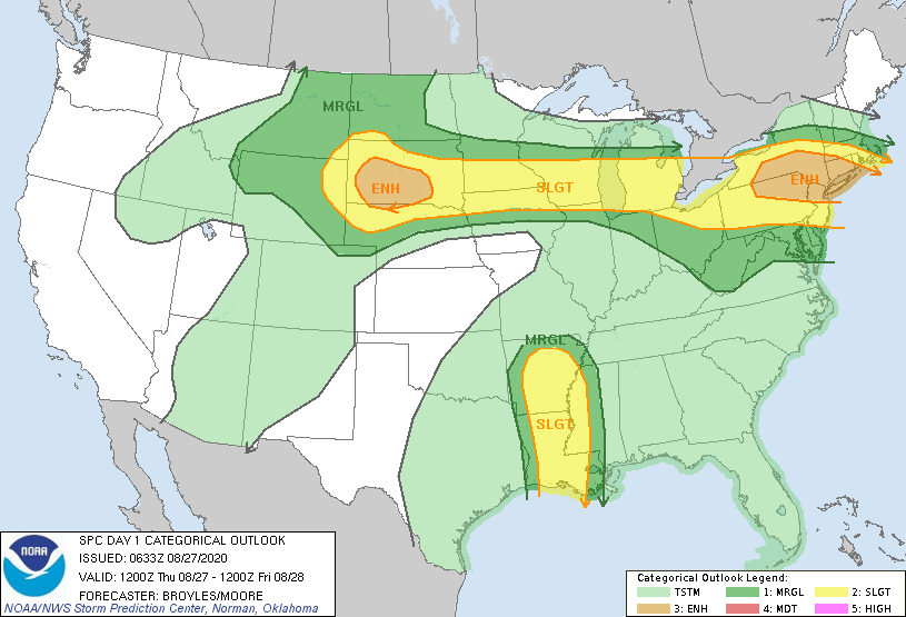
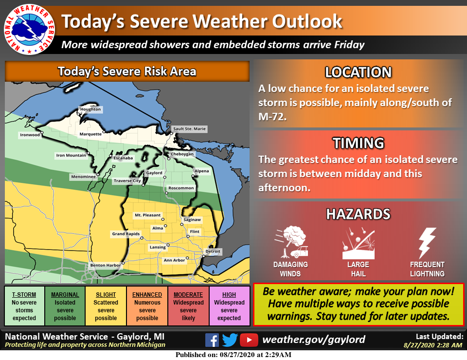
Here is the SPC outlook for today and tomorrow – notice the enhance outlook to our west for Friday – could this move further east? – We shall see.
[columns] [span6]
[/span6][span6]
[/span6][/columns]
[columns] [span6]
SW
[/span6][span6]
SE
[/span6][/columns]
[columns] [span6]
North
[/span6][span6]
U.P.
[/span6][/columns]
Forecast Discussion
- Risk for severe weather and flooding into Friday night

For much of today the region will be under speed divergence as the
low level jet pulls off to the east. This may limit the
thunderstorm risk. However tonight...especially later at night a
low level jet starts to develop in IA and WI with increasing
convergence here in MI. Instability builds along this developing
baroclinic zone. This will likely yield an expanding area of
showers and thunderstorm. Rainfall will become increasingly
efficient as the PWAT values climb to near 2 inches. Severe
weather risk through tonight may be isolated as the instability
is shown to be limited.

For Friday into Friday night the low level baroclinic zone
remains over the CWA as an upper wave drops in from the northwest.
The dynamic cooling coupled with increasing PWAT will spell
numerous showers and thunderstorms with heavy rain at times. Trop
level divergence peaks in the afternoon and evening as the PV
anomaly shifts eastward just north of the Great Lakes Region. If
the cells can train over the same area...which is a
possibility...an increased risk for flooding could develop.

Instability and deep layer shear build during the day on Friday. A
low level jet is shown to increase as it tracks through during the
late afternoon and evening hours. The CWA is shown to be in the
zone between higher helicity values to the north and stronger
instability to the south. Thus...an increased risk for severe
weather and perhaps tornadoes could develop. Close monitoring will
be needed going forward.

- Considerable cool down this weekend

Northerly winds behind the departing storm advect a cooler airmass
down into the CWA for this weekend. Temps at 925 mb bottom out in
the 11 to 13 deg C range Sunday morning. This is cold enough for
lake effect given water temps up over 20 deg C. We will feature
well below normal temperatures.
PRAISE GOD ,,,,Currently Getting Some Tbunder and Lightning and Spatters of RAIN!!! Nice little Storm Rolling in Ottawa County.
“HIGH” and Bone DRY here at the YARDofCUES in Alllendale .
Farmers Field Is Dusty and Crying Out for Rain.
Hope and Pray we get Some Today FRYday.
I hope you all are getting some much needed rain. 🙂
Rain and thunder here. I guess the rain dance we did earlier worked. lol!! 🙂
GR – storm proof, rain proof. Sprinklers on.
It’s official. 90 degrees! Third 90+ day out of the last four. Pretty incredible since some on here said summer was on the way out weeks ago.
Probably so overdue seeing how the last 90* degree day was so over a month ago!! I’m so sorry a cold front is coming but then again we’re supposed to have summer weather through October right? Lol….INDY
Currently 85* degrees out at thee YARDofBRICKS NE of GR feels so much warmer then that maybe it’s the dewpoint outside I don’t know crazzy I guess did it even hit 90* today yet if thats the case and it hasn’t only 2 days out of 5 days that was once predicted by the locals in Grand Rapids Michigan thats a win for me and Ricky the only bloggers that don’t like the heat on here well Mr negative loves the cold also so the 3 of us …lol… Hopefully we get some rain around here tonight ….INDY
Well you’re miles off target there. I don’t think anyone on here abhors the heat more than I do. And yes it did top 90 again today.
https://w1.weather.gov/data/obhistory/KGRR.html
Just another 90+ degree day with the heat index in the mid to upper 90’s. Makes the comments about this being a “cool” Summer almost laughable.
What a nice “gift”…two flawless days/nights of Summer, as a warm weather send-off. We can record this year as “an excellent Summer”…Hoping everybody made the most of it.
Seeing some chances of storms coming with a cold front some much needed rain would be nice we will tracking the storms today the breeze feels good outside have a super Thursday ….INDY
Because of the heat yesterday we took our walk much later at night out back. We went out about midnight and it was still a ridiculous 80 degrees out yet! Just felt strange being that warm at that time of the night. Hope we actually get some rain soon. We haven’t had a fire in several weeks now with all the burn bans in place.
I love these cool summers! Only one mini heat wave and starting tomorrow a big cool down! I love it!
I’m thinking it will be well over a month before we will see anymore 90* degrees starting tomorrow actually maybe many many months that would be ok with me ….. Welcome back to the blog Rocky I wondering about you I hope all is well my friend!!!!I INDY
All is well here Indy! Let’s get ready to rock n roll! Winter is right around the corner!
Who is Rocky? Pretty convenient he’s been gone for pretty much all of our warm 2020 so far!
The over night low at GRR and here at my house was 75. IF it stays above 75 until midnight it will tie 1973 for the warmest minimum for August 27th (a low of 74 was recorded in 1993 and 3 times the low was 73 in 2013, 1990 and 1977.) At the current time it is already 82 here at my house with a DP of 72.
Slim
Looks like today could be our third 90+ degree day in the last 4. Some models are showing summer weather right up to October. That would be almost 5 solid months in the 70’s-90’s. Love long summers!