Yesterday we had a low temp of 32.5° and a high of 43°.
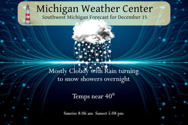
Today will be our last warm(ish) day for a while with temps near 40 or so in SW Michigan. The winter weather advisory for the counties north and east of Kent county remains in effect until 9 am. I suspect we will see winter weather advisories being rolled out later today for some of the lakeshore counties.
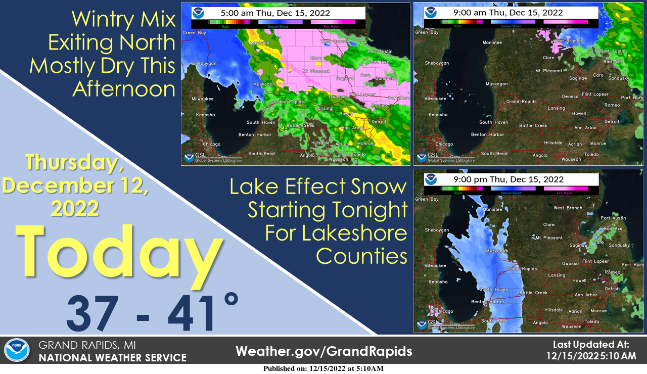
Some icing will be possible on roads and elevated surfaces this morning following overnight freezing rain/wintry mix, but conditions should dry out this morning as precip exits north. Conditions will by mostly dry this afternoon, then lake effect snow will begin tonight for lakeshore counties.
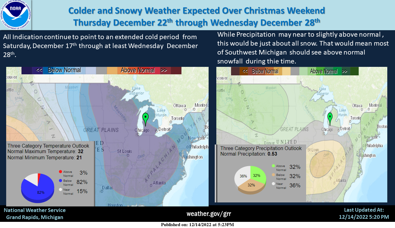
An extended period of cold weather with lake effect snowfall and possibly system snowfall is expected to bring a White Christmas to all of Southwest Michigan. Grand Rapids, in the past 10 years has had a White Christmas in 2013, 2016, 2017, and 2020. It is looking more and more like we will be able to add 2022 to that list. For Lansing, it would be 2012, 2013, 2016, and 2017. For Muskegon 2013, 2016, 2017 and 2020.
7-Day Forecast 42.96°N 85.67°W 12 15
Forecast Discussion
-- Current Wind and Winter Weather Headlines --

Grand Rapids recently hit 45 mph at the airport which is Wind
Advisory criteria. Elsewhere, Muskegon has also peaked at 45 mph
with Holland reaching 44 mph. So, the wind advisory has been
working out fairly well. No changes planned to the Wind Advisory
which runs through 700am. The core of strongest winds progresses
from south to north early this morning and should be pushing north
of Cadillac in the 800am to 900am hour.

As for the Winter Weather Advisory the area has worked out quite
well, with the near an sub freezing air temperatures centered in
the advisory counties. We have had some icing here at WFO Grand
Rapids, but not on the sidewalks or parking lot. Air temperature
here has been steady at 33 degrees. The icing has been on elevated
surfaces like trees and metal light poles. The counties bordering
the advisory especially Muskegon and Kent may have had some light
impacts in northern portions, but overall impacts are limited with
marginal surface temperatures. The highest icing potential in the
advisory counties is likely to occur in the next 3-4 hours as a
band of heavier precipitation works through the area. So, if
impacts have not occurred yet, they will be likely in the next few
hours. By daybreak, the warm nose aloft is eroded/shunted to the
east and the freezing precipitation should switch over to frozen
(snow).

-- Prolonged period of lake effect this evening to Sun. morning --

A slow moving vertically stacked low will slowly move from
Minnesota and Iowa today to the Upper Peninsula Friday night and
into Ontario over the weekend. Colder air will flow into the area
on westerly winds and set the stage for a long period of lake
effect snow over Western Lower Michigan. The upper low will also
provide a deep layer of moisture.

We will discuss moisture first in the moisture/instability/lift
equation that makes dictates lake effect snow (convection).
Moisture depth increases significantly this evening to in excess
of 15,000 feet as the upper low moves our way. That depth of
moisture in a lake effect scenario is fairly rare. Moisture depth
will be between 10,000 and 20,000 feet tonight, Friday, Friday
night and Saturday. So, the first ingredient is beyond well met.

Instability is also favorable given a lake water temperature
around +6C and overriding air at 850mb that is around -10C much of
the time frame of concern (through Sunday). That produces delta
t`s obviously around 16 degrees C which yields lapse rates in the
1000-850mb layer around 9C/km. This is solid and more that need
to produce strong lake generated snow showers.

Finally, lift is seen in BUFKIT overviews in the low levels which
also extends at times through the dendritic growth zone and
beyond. Two main time frames when synoptic scale lift (mid level
shortwaves moving through) will aid the process look to be tonight
and again Friday night into Saturday. That said, lake effect snow
will roll unabated from tonight right into Sunday morning.

We are looking at Winter Weather Advisories for lake effect snow
from tonight into Saturday night. Given the headlines we have out
now though, will not confuse things with more headlines. Will let
this expire this morning and the day shift will likely issue new
Winter Weather Advisories for Western Lower Michigan. As it stands
now thinking the most impacted counties will be Mason, Oceana,
Muskegon, Ottawa, Lake and Newaygo tonight and Friday. Friday
night into Saturday those counties along with Allegan, Van Buren
and Kent. Most of the western two tiers of counties will get in
the action by the time its winding down on Sunday. Accumulations
in the counties that see snow the bulk of the time will likely hit
the 6 to 10 inch range over the 48-60 hours.

-- Colder air looms in the longer ranges --

The Monday through Wednesday time frame will be dominated by
ridging at the surface and therefore precipitation will be
limited. Air will be plenty cold for lake effect snow, but the
ridging may act to suppress it. Very cold air works into the
Northern Rockies filtering into the plains with time. Looking at
the evolution of it though there is moderation that occurs before
it makes its way into the Great Lakes. So, -30C air surging into
the plains never makes it into our area at least through
Wednesday. The GFS is colder than the ECWMF so there is some
disparity in the operational models. For the snow lovers in the
crowd, what snow we do get this weekend will stick around next
week with highs in the 20s.
Ground is covered with snow out in my hood … Here comes our white Christmas baby yeahh …INDY
It is great to see the cold and snow returning! Who wouldn’t want snow in MI in December?
Kent county will get added to the WWA by Friday evening! What a week!
Mason-Lake-Oceana-Newaygo-Muskegon-Ottawa-Allegan-
Including the cities of Ludington, Baldwin, Hart, Fremont,
Muskegon, Grand Haven, Jenison, and Holland
200 PM EST Thu Dec 15 2022
…WINTER WEATHER ADVISORY IN EFFECT FROM 7 PM THIS EVENING TO
7 AM EST SATURDAY…
* WHAT..Lake effect snow expected. Total snow accumulations of 4
to 8 inches with locally heavier amounts possible.
* WHERE…Portions of southwest and west central Michigan.
* WHEN…From 7 PM this evening to 7 AM EST Saturday.
* IMPACTS…Plan on slippery road conditions and reduced
visibilities.
Temperatures are falling here comes the snow .. INDY
Breaking News ……it is a strong possibility that most of MI will have a White Christmas this year! Winter Wonderland! The chance of a white Christmas in GR is now up to 99.9%! Who would have thought?
Winter storm and Winter weather advisorys coming this weekend get ready…INDY
What, it is not a quiet week?
The official H/L yesterday at Grand Rapids was 39/30 there was just a trace of precipitation recorded before midnight there was no snow fall and there was no snow on the ground. The overnight low here in MBY was 32 and there was some ice before the temperature went up. At the current time it is 37 here. There was 0.35” of rain fall overnight. For today the average H/L is 36/25 the record high of 62 was set in 2021 and the record low of -7 was set in 1917 the record snow fall amount of 6.2” was set… Read more »
Now with a expected extended period of cold weather with lake effect snowfall and possibly system snowfall is expected to bring a White Christmas to all of Southwest Michigan. Grand Rapids, in the past 10 years has had a White Christmas in 2013, 2016, 2017 and 2020. It is looking more and more like we will be able to add 2022 to that list. For Lansing it would be 2012, 2013, 2016, and 2017. For Muskegon 2013, 2016, 2017 and 2020.
Slim
Yes and I have been predicting this for days/weeks, however most people disregarded the data and long range models! Indy and I have been all over this impending pattern change! Bring it!
Since Nov 20th, the weather has been very uneventful here until early this am. That wind was kicking! It woke me 3x.
This was our 3rd Wind Advisory since I hung our Christmas lights outside. I know this because each time a Wind Advisory is issued, I hold my breath – hoping that my lights aren’t blown down. I just went out and did an inventory and all are still up, thankfully.
Our wild week of weather continues! Get ready for a WWA and accumulating snow and cold! Anything but a quiet week of weather! Rock n roll will never die!
What? No takers on the white Christmas bet?
At this time for us living in West Michigan there looks to be a good chance of a white Christmas. For the unnamed poster who lives in the east side of the state maybe not so much.
Slim
How about this guy who lives in the middle of the state? I’m hoping for a white Christmas, but I will believe it when I see it.
Yours is not a given yet but still very possible!
While the conditions look good for lake effect it is always hard to say for sure and so many pieces have to come together. Lansing has a better chance of getting some lake effect than say Detroit or Bay City.
Slim