We have been speculating about rain chances for the good part of three weeks now and most of the medium range guesses have been ill-conceived with the exception of the northern lower very little has fallen – a trace in many locations. The last time we had significant rain was the .55 of an inch we had on April 11 (in Otsego).
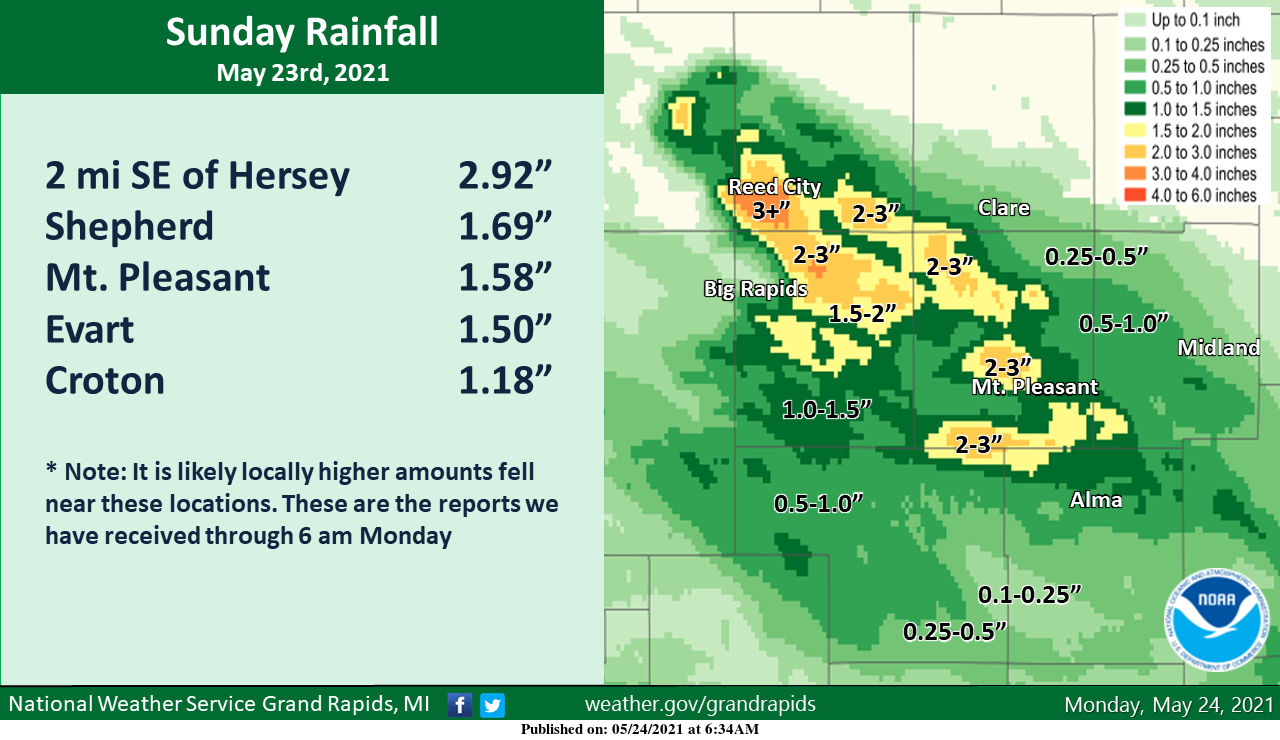
Here is a map of rainfall across Central Lower Michigan yesterday. Some locations saw some locally heavy amounts as the storms sat over the same area for an extended time. Some minor flooding did occur up near the Reed City and Hersey area.
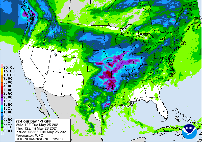
QPF estimation of rain through Friday
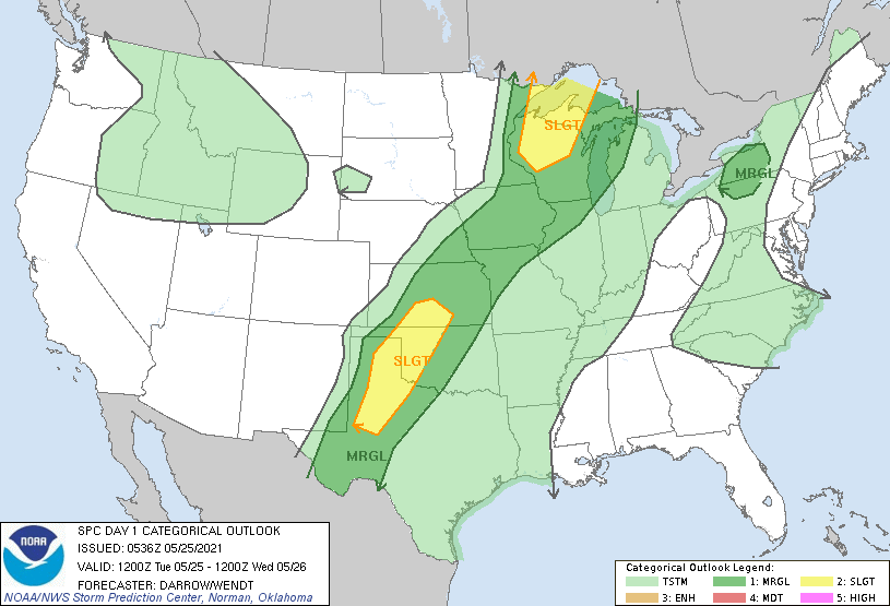
There are hopeful signs of more widespread rain the Southwest Michigan beginning later this afternoon through Friday morning. The highest coverage of showers and storms in West Michigan looks like it will be late Tuesday evening through Wednesday morning (80% chance), and late Thursday into Friday morning. A few storms early Wednesday could be on the strong side before they clear out of the area. The SPC is showing Michigan to be in the General Risk area for severe weather.
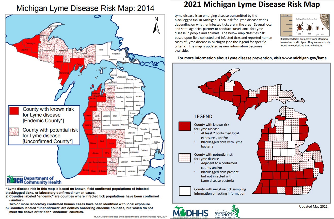
If you live in the country (as I do) you may have noticed an uptick in ticks. With the dry weather, we have been pulling the nasty critters of ourselves and our many animals. Of course with the ticks come the possibility of Lyme disease.
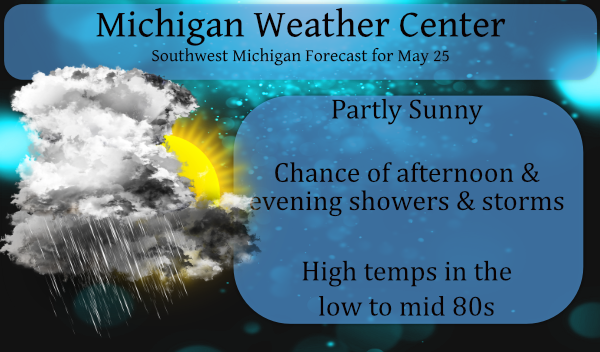
Forecast Discussion
--Warm and windy today into tonight--

Swly low level jet ramps up today into tonight, peaking around 40
kts, as robust nrn stream shortwave over Saskatchewan moves
toward Lk Superior. This wave helps to deepen a sfc low to 986 mb
by 12Z Wednesday near Hudson Bay, with the accompanying sfc cold
front sliding southeast through the area late tonight and early
Wednesday.

Once deeper mixing develops this afternoon, expect wind gusts to
reach 30-35 mph. The core of the LLJ arrives in the area this
evening and with warm temperatures in the 70s persisting deep
into the night, would expect some gustiness to continue even
after dark.

High temps today are fcst to reach the mid to upper 80s under
filtered sunshine. Warmest temps will be south and east of GRR,
away from the cooler/marine-influenced air flowing in from Lk MI
via swly flow. CAMS are suggesting some widely scattered sfc based
convection developing this afternoon/early evening within this
corridor of warmer/more unstable air, from AZO toward the thumb,
where SBCapes of 500-1000 J/KG will be present e/se of the lake
shadow.

--Showers and storms likely tonight, early Wednesday--

Best chance of storms will be tonight and early Wednesday while
the cold front is crossing the area. Convection begins this
evening around Ludington in response to a pre-frontal sfc trough,
good moisture convergence, and MuCapes of up to 1500 J/KG. These
storms will have a gusty wind potential with core of the LLJ
overhead and perhaps a hail threat as well.

Instability is progged to wane through the night, so while the
storms will continue to develop south and east with time, the
marginal strong/svr storm risk north of MKG this evening should
diminish. However a locally heavy rainfall threat may persist as
axis of 1.5" PWATS ahead of the cold front will be in place.
Isolated 1"+ rainfall amounts possible tonight.

Slight possibility of storms re-intensifying south and east of GRR
during the mid morning to early afternoon period Wed before the
front exits, so can`t rule out a stronger storm near JXN before
the cooler and drier air filters in Wednesday afternoon.

--Rain Thurs night into Friday; chilly Friday--

Models still advertising widespread chilly rain event for
Thursday night into Friday as a sfc low tracks by to our south.
Sfc high situated north of Lk Superior will be delivering chilly
air in the low levels via brisk northeast winds, with highs on
Friday probably not making it out of the 50s. Good potential for
many areas seeing over one half inch of rain before diminishing
trend sets in Friday afternoon.

--Mainly dry holiday weekend, cool--

Sfc ridging is shown to prevail over the holiday weekend, which
should lead to mostly dry weather. Temperatures will be a bit
below normal with highs in the mid 60s saturday rising to around
70 for Sunday and Monday. Expect chilly nighttime temps in the 40s
due to the dry/low dew pt air mass. Wouldn`t even rule out some
ptchy frost up north around Clare Saturday night.
This will be the hottest day of the week woo woo cold front is close bring on a cool and nice Memorial Day weekend woo woo …. Happy Memorial Day!! INDY
It may not reach 60 Friday, but the rest of the weekend looks great.
Yes beautiful and cool no heat I wll take it!! Starting to hear some lows in the 30’s talk especially north of Grand Rapids perfect fire Weather!! INDY
87 here and 90 in Battle Creek. Feels like July.
BTW, 87 is just one degree shy of the daily record.
When burning a fire feels great and have a hoodiee on during the last weekend of May PRICELESS!! Happy Memorial Day ..INDY
Don’t think having a fire right now is the best idea. Most areas are under complete burn/fire bans because of how extremely dry it has gotten. All it takes right now is one little spark or ember to ignite a massive wildfire.
NWS GR nailed the forecast when it came to pinpointing where the heaviest rain would fall on Sunday. They’re not always right but when they get one perfectly, it is remarkable.
We removed two ticks from our dog in the past week. Bad spring for pollen/allergies and ticks.
NWS Detroit also nailed it on the temperatures for Sunday. Calling for the temperature to fall into the low 50’s in the afternoon and boy it did. And it got very windy as well. From Bay City we could see the dark clouds to the west and sure enough on the way home we ran into some of the heaviest rain I have seen is some time. In the rain the temps were in the upper 40’s and on the side of the road the fields were flooded.
Slim
Pretty much the same here. The temp dropped 20 degrees in just two hours.
While we wait for the expected rain fall over the next few days it is still dry in many parts of west Michigan. That was not the case to the NE of GR on Sunday where just to the north and north east a lot of rain fell. And there were some very cold afternoon temperatures as well. Yesterday was a very nice warm day and I would expect the same for today. The official high for Grand Rapids was 85. Here at my house the high was 87. The overnight low both here at my house and officially at… Read more »
We reached 85.8 yesterday with a low of 62 overnight
Going for our 10th straight warm day!
It was a strange day up in Bay City on Sunday. The temperature fell from 80 at 11AM down into the mid 50’s at 12:30 and down to 52 by 3 pm and it was windy so yes it was cold.
Slim
Only in the 50’s Friday and low 60″s the rest of the holiday weekend in Ludington definitely packing the hoodieee only the best for the end of May baby and a big fire going nice and cool weekend ahead woo woo happy Memorial Day …INDY