We have a more typical fall pattern of cloudy days for the beginning of October though temps remain on the warm side. The cold air remains in Siberia where temps are in the 20s and 30s we keep in mind what generally goes around comes around.
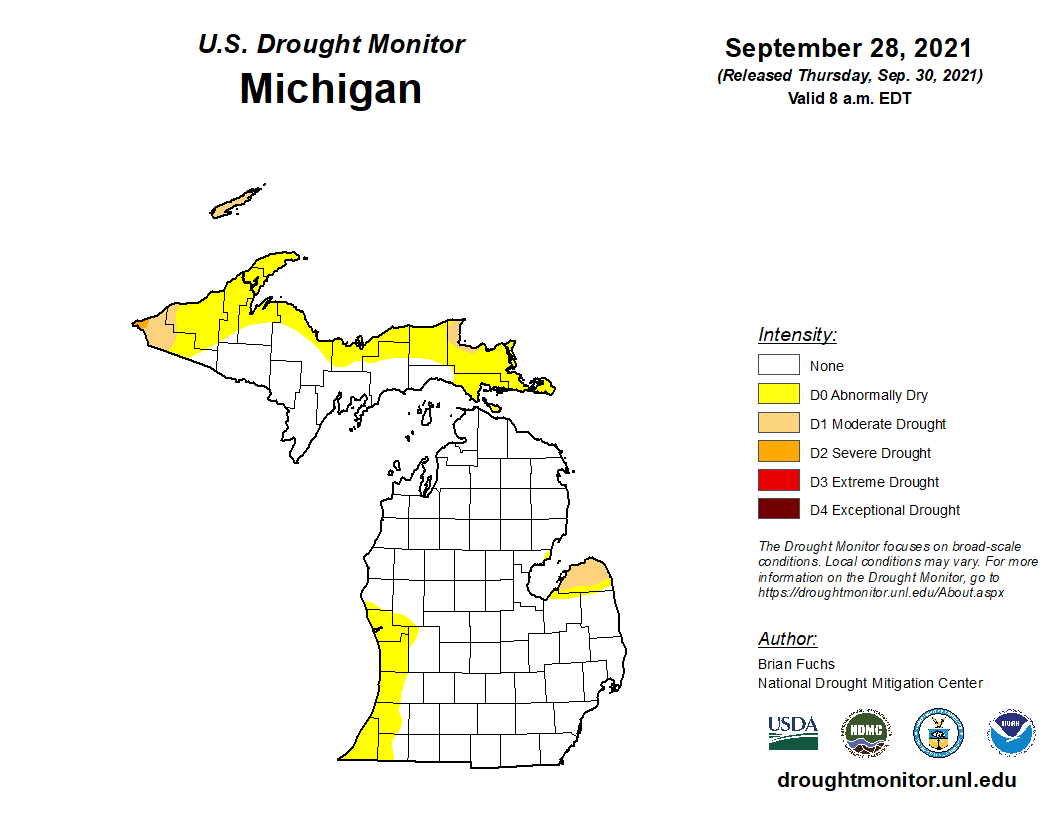
Much of the U.S. west of the Mississippi River remains in extreme to exceptional drought conditions. Michigan is in better shape though it has been fairly dry in the Lake Michigan counties, the thumb, and the northern U.P. I am thinking the dry slot depicted in Allegan County should extend further eastward especially along the Kalamazoo River valley area where I live.

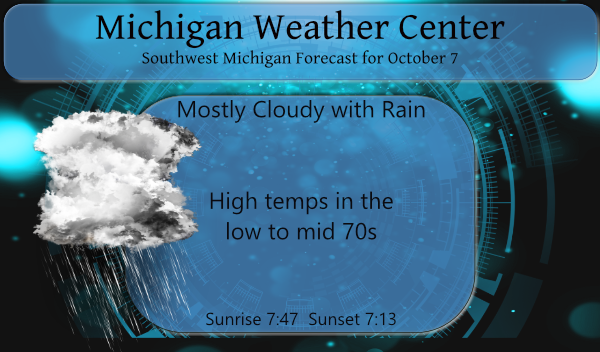
Showers will begin moving in from the south to the north today beginning a wet period lasting through Friday. There are hints our temps may return to the normal of the 60s late next week.
Yesterday’s high temp was 69° and the low was 57°. We had less than a minute of sunshine which teased us through the cloud cover.
Forecast Discussion
-- Chances for showers and a few storms at times into Saturday --

We will see the chances for showers and a few storms increase
through this afternoon across the area from South to North. This
increase will be the result of moisture being fed by a weak low
level jet to the north of a warm front that is currently south of
the area toward the Ohio River Valley.

Much of this activity will be elevated in nature for much of the
area, much of the day being north of the warm front. Some of this
could become closer to surface based as the warm front moves over
the area late this afternoon. Models are forecasting CAPEs
approaching 1,000 J/kg being boosted by some diurnal heating, and
dew points well into the 60s. The severe threat looks to be fairly
limited as wind fields and resulting layer shear values will be on
the lighter side. Can not rule out a stronger storm during peak
heating with decent instability, so convection will have to be
watched. Locally heavy rain would be a threat with precipitable
water over 1.5 inches, and some hail will be possible with mid level
lapse rates a tad over 6 C/km.

We should see a trend down in coverage and strength after sunset
tonight as we lose the diurnal heating, and the low level jet axis
shifts north of the area. Coverage will once again ramp up on Friday
with diurnal heating, and the fact that the upper low/wave will be
moving right toward the area. Instability builds to 1,000+ J/kg once
again, leading to thunderstorm potential. Once again however, upper
level winds/shear are not really favorable for much severe weather.

The upper wave will be slow to exit the area to the NE, leading to
shower and storms chances to linger into Saturday. The better
chances for showers and storms will be further NE in better
proximity to the exiting upper wave.

-- Next chance for showers/storms Late Monday-Tuesday --

Much, if not all of the area should remain dry on Sunday. The only
place that could see a small chance of rain would be Central Lower.
This will come via a developing warm front that will be lifting to
the NE through the area. The forcing with this front via the core of
the low level jet will stay mostly N/NW of the area. We will see
mainly the warmer air that will be surging across the area.

We will stay in the warmer and dry air through most of Monday,
before showers and storms arrive Monday night. A cold front tries to
move into the area, but stalls out to our west. A strong upper wave
will then drive a sfc wave NNE along the front, helping to push it
through the area. The best chance for rain will come Monday night,
with a few lingering showers/storm holding in on Tuesday until the
supporting upper wave moves through.

-- Warmth continues next week ahead of another stronger system --

Even with a "cold front" moving through early Tuesday, we will not
see a significant cool down yet. Temperatures will stay above average
as the air is not all that cool behind the front. Warm air advection
and an upper ridge quickly returns by Wednesday ahead of a strong
storm moving into the Plains States. Right now, rain looks to hold
off until just beyond this forecast period on next Thursday. This
system will likely be the beginning of the end of this much above
average period of temperatures.
Truly incredible all of the skiing I have gotten is over the last 2 winters with all the non stop warm weather hype! Get ready for a rocking winter baby! Incredible!
The overnight low here at my house was a very mild 63 the official low at GRR was 62. At this time it is cloudy and here with a dew point of 62. So far this fall season the lowest it has gotten at Grand Rapids is 47. This year will be the latest that the first low of 46 of less has happened here at Grand Rapids in recorded history. The old latest year was in 2016 with it did not reached 46 until October 8th. The next milestone will be 43 that record is now held by 1931… Read more »
Getting into some impressive stats. Thanks Slim!
Wow!
Slim = the king of obscure & amazing facts/stats.
This warm weather the past few years has been truly incredible. Warm seasons have been extended by weeks/months. Winter has been reduced to 2-3 months or less.
It will soon be the second week of October and I haven’t even had to get my jackets out.