This is the first day since June 27 we have had rain in the Otsego/Plainwell area. We have had .77 of an inch as of 7 am.
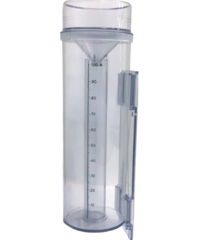 I use the ‘official’ CoCoRaHS gauge (to the left) for my measurements. I also have a digital gauge. The digital gauge is generally a tenth of an inch difference from the analog gauge.
When it rains, your gauge measures the amount of precipitation that falls through the area at the top of the gauge. When you read the gauge, you measure the depth of water that has fallen through the area and accumulated in the bottom, which is the depth of water.
How, you may ask, can this gauge work properly if the inner tube is 10 inches long but only records 1-inch depth of water? The reason has to do with accuracy. The National Weather Service (NWS) has adopted the criteria that the gauge should be able to measure to an accuracy of 0.01″. The problem with a gauge that’s 4″ (CoCoRaHS) or 8″ (NWS standard) in diameter, is that it’s nearly impossible to read the depth to an accuracy of 0.01″. That’s where the funnel and inner tube come in.
The funnel of the CoCoRaHS gauge squeezes the water into the area of the inner tube, which is 1/10th of the area of outer cylinder (The NWS gauge has a similar funnel and inner tube). By reducing the area that the water falls into, the depth can be stretched by the same factor of 10. In this way, the total volume of water (area times depth) that fell through the top of the gauge and the total volume in the inner tube are the same. This stretching allows us to read the depth of water an accuracy of 0.01″.
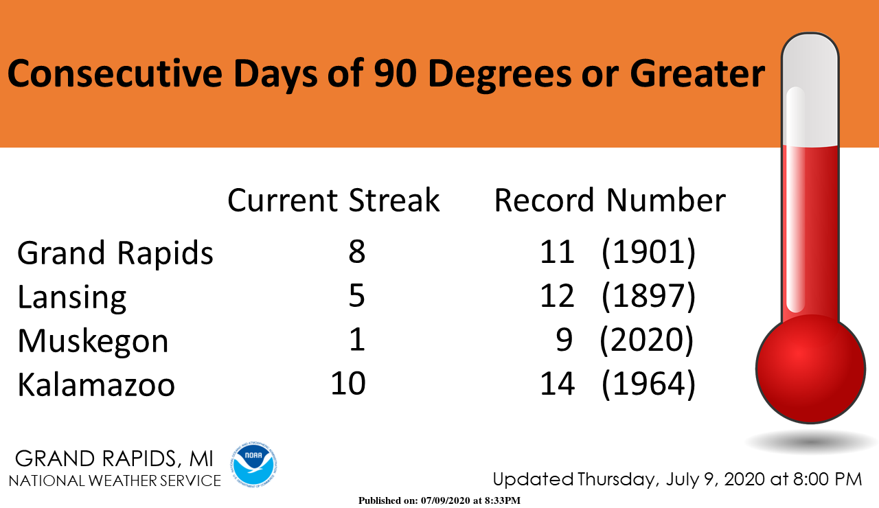
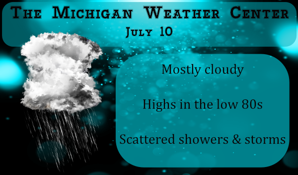
We have ended our string of 90° days. Today will we will continue to see scattered showers with perhaps an embedded storm. High temps will be 10 to 15 degrees cooler though humidity levels will be high. This weekend looks to be pleasant with lower humidity and temps compared to the past week.
Currently 74* degrees out at thee YARDofBRICKS NE of GR so we did not break the 90* degree streak of 11 officially ended at 8 days and it never got above 95* degrees and no record highs reported in Grand Rapids!! We have Heat wave 2020!! Have a super night open the windows up the fresh air is here ….INDY
81 degrees here with a dew point of 71. Cooler temp, yes. Dryer air, nope. Thick as a sauna out there.
Gauges showing .90 inches of rain overnight. 2.6 inch two day total…more than enough.
Definitely a humid air mass. Even the U.P. Has dew points in the 70ls!
http://www.usairnet.com/weather/maps/current/michigan/dew-points/
Dew point of 73 here. I need to work on the deck this weekend. Hoping the humidity will dry out some.
0.36 here. Would have loved to had more. Guess we will take what we can get.
I have the CoCoRaHS rain gauge and love it. Very accurate. I also have a digital one too. Sometimes they are very close but not always. I always use the CoCoRaHS for an accurate reading. I got 2.22 in of rain here in the last 24 hrs in Comstock Park. Much needed!!
Currently 70* degrees out at thee YARDofBRICKS NE of GR a lot different then yesterday at this time we will take it ….INDY
Thankfully the mini heat wave is over and we received some beneficial rain! Starting tomorrow, goodbye high dew points and temps in the 90’s! This so called heat wave was pretty short lived and wimpy!
Once called the biggest heat ever on here lol…What low 90’s come onnnnnn ..INDY
Yep, record breaking heat wave for Muskegon and top 5 for GR. And more coming!
July is now +7.4 degrees above average. In addition, GR has received 81% of total sunshine. What a start to summer!
Well Slims stats show this was one of the longest heat waves in history with records set. Sad part is we’re only a third of the way through July with another hot blast coming next week.
Well this so called biggest heat wave ever will come to a end today not sure how supposed to be the biggest ever when no records where broke not even close like I said before but then again? Lol…. Loving all the rain this morning the yard is happy enjoy the 80’s this weekend …. Sprites INDY
At Muskegon this year was their biggest heat wave. I am not sure why that happened but it was 1. either the winds did not come in off the lake I know there was a lot of east winds at the stare of July. 2. of the timing of the lake breeze was later thus it was able to get warmer then in past years. 3. Or there may have been a change to where the readings are taken. 4. Miss calibration of the equipment.
Slim
Now for Grand Rapids it was one of the longer strings of days at or above 90 but during the wave the hottest days were 94 and at night most got down below 70. So this will be in the history books one of the longest heat waves at Grand Rapids and Kalamazoo but not so much at Lansing.
Slim
Typical Indy. Trying to downplay the incredible heat but hypes an inch of snow in February. Yawn.
May 12th frost and frezez warnings less then 2 months ago ….INDY
Exactly my point. What insanity!
Love short summers lol….
Oh wait, we’re already above average for 90+ days and summer just started. Whoops!
Here at my house I record a LOT of rain. In 3 separate rain events I recorded a whopping 3.17″ of rain. While the power staying on we did lose the internet last night. That seems to be happening a lot this year so far. At this time the rain has stopped I have a current temperature of 71 with a DP of 69.
Slim
We finally received rain as well! 1.21” in the gauge. A very humid 71 degrees this morning with a dew point of 70.
We had beautiful, yet ominous-looking clouds this morning. We had wind and thunder for about 30 minutes. When it finally did rain, it only lasted about 10 minutes. It’s better than nothing.
I need a new rain gauge. I think I shall shop for a new one today.
This is where you can order the CoCoRaHS gauge:
https://www.weathershack.com/product/productive-alternatives-stratus-rain-gauge.html
I have had my gauge for many years now and this is the first time that I have ever recorded over 3″ of rain in less then 24 hours. This ran fall was rather local to here northwest of GR.
Slim
Thanks Michael. I could use it today. Loving this rain!