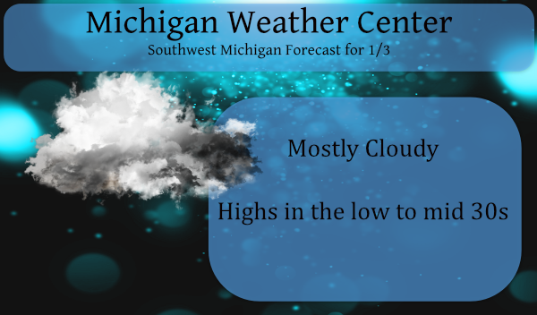
As the title states, we will see a mainly uneventful week ahead possibly stretching into mid-month. There are hints of warming in the Arctic stratosphere which would cause the cold air to be displaced southward, however, we will have to wait to see if the cold will move into Eurasia or the North American Continent. I, along with other Mets are looking at a colder, snowier second half of winter in the eastern U.S. which would be in line with the La Nina we have in place this winter. Below is an explanation of how this works.
A stratospheric sudden warming is perhaps one of the most radical changes of weather that is observed on our planet. Within the space of a week, North Pole temperatures can increase by more than 50 K (90°F). For example, on 17 January 2009 the temperature at the North Pole near 30 km was about 200 K. Over a 5-day period, the temperature increased to 260 K (a change of 60 K or 108°F).
These stratospheric sudden warmings are caused by atmospheric waves that originate in the troposphere. The waves are forced by the large-scale mountain systems of the northern hemisphere and the land-sea contrasts between the continents and oceans. The waves are also characterized by their very large scales, typically referred to as planetary-scale waves. The stratospheric wind structure filters the smaller scale waves, only allowing the planetary waves to propagate into the stratosphere. As the waves move upward into the stratosphere they have two effects: first they will often push the polar vortex away from the North Pole—bringing warmer midlatitude air poleward, and second, they produce a downward motion field that also warms the polar region.
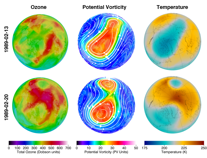
Northern hemisphere total ozone, potential vorticity on the 460 K potential temperature surface, and temperature on the 50 hPa pressure surface for 13 and 20 February 1989. This day is an example of a sudden stratospheric warming.
An example of stratospheric warming is shown above. The top row of images are for 13 February 1989. The PV image indicates an elongated polar vortex (top middle image), while polar temperatures are relatively cold (top right) and total ozone is relatively low (top left). A week later on 20 February 1989, the polar vortex has split into two separate parts (bottom middle). This is known as a wave-2 pattern, since there are two high and two low centers. Note that the temperature (bottom right) and total column ozone (bottom left) have considerably increased at the pole. Other events are associated with a wave-1 pattern, where the vortex is displaced off the pole. This results in one side of the hemisphere having a relative high, while the other side has a relative low.
The most dramatic stratospheric sudden warmings are known as major warmings. During major warming, at about 30 km the normal cold polar and warm midlatitude gradient is reversed and the west-to-east polar night jet reverses to an east-to-west flow. Sudden warmings are always characterized by large-scale, large-amplitude wave events. While major warmings only occur every other winter or so, wave events of weaker amplitude occur frequently during the winter season. All of these wave events act to warm and increase ozone levels in the polar region generally in proportion to their amplitude. The waves also act to strip off streamers of the polar vortex (similar to the cutting of a lathe). The waves cumulatively act to keep the polar region much warmer and ozone much higher during the winter than would occur in their absence.
The final warming is the last stratospheric warming of the season. After this warming, the stratosphere never recovers to its previous state and the vortex breaks up and dissipates. The final warming often occurs in March or April. Sometimes the stratosphere never recovers from what would otherwise be a mid-winter major warming in January or February, and that warming becomes the final warming.
A bit of a longer read, but good article today in the Free Press on Michigan’s dying Winters.
https://www.freep.com/in-depth/news/local/michigan/2021/01/03/michigan-winter-festivals-climate-change/3954384001/
That is a really good, if not sobering article.
This afternoon, I went outside to shovel the morning snowfall. Never mind. It all melted.
Really liked this paragraph!
“The planet overall is warming, but states like Wisconsin, Michigan and Illinois are getting warmer, faster,” said Don Wuebbles, a professor in the Department of Atmospheric Sciences at the University of Illinois.
What? You actually believe in global warming? That is a big surprise!
Just the words polar vortex puts a smile on my face! Let’s hope it hammers West MI! I love it!
Lot of info there, thanks MV! Let’s hope if it happens the cold air swings over to Eurasia. Better off for everyone.
I tried to follow that, but you kinda lost me at “planetary waves propagate into the stratosphere”. Guess I have the heart of a meteorologist and the physics comprehension of an eighth grader! :< (
A quick seasonal total snow fall update Grand Rapids 6.9” Muskegon 11.8” Lansing 9.6” One more hint on how mild this winter season has been so far the coldest it has officially gotten here at Grand Rapids so far this season in 15. This winter season will end up being tied with 1924 with being the 7th latest date for that to happen. The latest was January 30th, 1932. This winter season will be at least the 4th latest for the first night of 14 or colder. The current latest are the 1932 then January 21st 2013 and then January… Read more »
Yet another record to shoot for in this crazy mild Winter. Love these stats you keep digging up for us Slim!
I believe it’s been snowing now for 3 days straight who would of thought??? Loving the modles for mid January cold …Happy New Year ….INDY
So far I have recoded .02” of new snow fall. At this time very light snow is falling with a temperature of 30.
Slim
I don’t recall hearing about stratospheric sudden warmings before, so I appreciate you and Slim bringing it up. Question: “by more than 50 K (90°F).” What is K?
Just stopped snowing here. We only received a dusting – just enough to be very annoying, as the driveway and sidewalk were perfectly clear and dry when I went to bed last night. Oh well, Lord knows I could use more exercise/activity.
In the K (Kelvin scale) 0° is absolute zero below which temperatures do not exist. Here is a calculator.
https://www.lenntech.com/calculators/temperature/temperature.htm
Slim
I thought it was Kelvin, so I googled it before I posted my comment. When you use that calculator, it says 50 K = -370 F (not 90 F). That is why I posed my question.