First up let’s look at yesterdays snowfall totals:
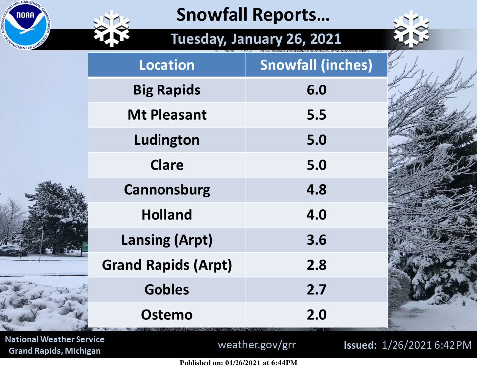
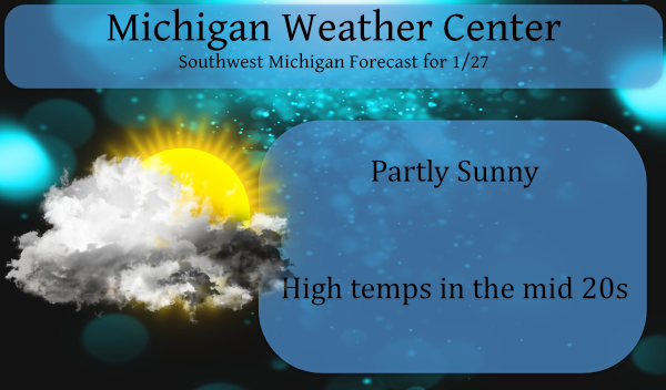
We had two inches here in Otsego, not a lot but enough to freshen up the ground cover. We have a cold morning with a temp of 17° at 6 am. We should see some sun today with temps recovering into the mid-20s.
In my lifetime I have experienced two great snowstorms here in Michigan and a couple when I lived in Maine. The biggest was around 48 inches overnight in November of 1972 when I lived in the upper highlands from a noreaster moving up the Atlantic coast. Out there they sneered at these ‘minor’ accumulations and everything was opened in the morning. I have seen some monster snowblowers on the plow trucks from New England on up to Montreal and Quebec. I used to talk to Craig James about the snows in Maine – he used to be stationed out there when he was in the army.
Of course, we have the storms of 67 and 78 which some of you may remember. Here in Michigan, we have major road systems to keep open so any major snowstorm we have tend to close things in a hurry.
The storm of 1967 was mainly a snow event without much wind. Battle Creek recorded 28.6 inches of snow. The storm total at Lansing is 23 inches and 18 inches at Grand Rapids. I remember having to shovel a lot of snow that year.
The storm of 1978 was known as the Cleveland Superbomb which moved north from the Gulf of Mexico and deepened explosively, becoming one of the worst blizzards in Midwest history. From one to two feet of snow falls across southern Lower Michigan, whipped into huge drifts by strong gusty winds. Several new records were set including a new record low sea-level barometric pressure of 28.68, observed at 6:00 AM.
We had 19 inches of snow between Martin and Otsego with 20-foot drifts. My fiance at the time and I had to crawl our way twice a day to get to the horse barn which we rented about a quarter-mile away to feed and water the horses. It took a road grader with a V-plow to clear out our country roads about a week later. I remember snowplows getting stuck, what a mess.
At least 9 deaths were attributed to the blizzard, most roads were impassable, roofs collapsed under the weight of the snow and the airport in Grand Rapids was closed from late on the 25th until the 27th. Governor Milliken declared a state of emergency and requested additional federal aid for snow removal.
Other notable storms:
1994: A snow and ice storm brings travel to a halt across Lower Michigan. Freezing rain causes widespread power outages and results in 5 million dollars damage.
1977: Buffalo, New York is hit with the worst blizzard in its history. Meanwhile, lake effect snow squalls also pummel areas in western Lower Michigan with more than a foot of fresh snow being piled into huge drifts by strong winds.
Here is the NWS write up on the ’78 blizzard:
“A GREAT STORM IS UPON MICHIGAN”
THE GREAT BLIZZARD OF 1978!
National Weather Service Detroit/Pontiac, MI
Updated January 4th, 2008
As with the huge snowstorm of December 1974 another even more powerful (in terms of intensity/extent) storm is of strong interest to all meteorologists who have studied winter storms in the Great Lakes. This storm is also of interest and remembrance to many longtime residents of the Great Lakes, the Upper Ohio Valley and Ontario, Canada who had to deal with winter’s full fury late in January of 1978. In addition, the storm certainly casts many memories for those of us who were on duty and worked during the storm…while being in awe of the development and subsequent immense strength of this great monster. With the 30th anniversary of this Great Blizzard at hand, it is worth taking a step back in time to re-live this monumental example of nature’s fury.
While there are several contenders for the worst blizzard ever to hit the Great Lakes in relatively modern times (since 1870 when records began in Detroit), the immense and intense Blizzard of January 26-27th 1978 must rank at or near the top along with the Great White Hurricane of 1913 with its similar track and powerfulness.
The incredible Blizzard of January 26-27th, 1978 evolved out of a winter that was infamous for cold and storms. The Winter of 1977-78 thus far had been one the coldest, since records began, in many areas from the Rockies eastward to the Appalachians. Mammoth blizzards occurred late in January and early February from the Midwest to the East Coast as strong Arctic plunges dove south into the country and met up with the warmer winds from the deep south. The winter of 1977-78 was similar to its predecessor (1976-77) in terms of cold. The main difference between the two winters, however, came in February. In 1977, temperatures moderated rapidly during February, while in 1978, the cold actually worsened – with several locations reporting their coldest recorded February to date. The Winter of 1977-78 is written down in the record books as Detroit’s seventh coldest winter, Flint’s fifth coldest and Saginaw’s sixth. West of the Rockies, it was a different story as a dominant upper ridge of high pressure provided a relatively mild winter, with some stations even reporting one of their warmest winters on record.
The Great Storm
Since there were some forecasted variances of the intensity and track of the storm, and considering the primitive model of the day (LFM – Limited Fine Mesh), forecasters did an admirable job in forecasting one of the most severe winter storms ever to hit the Great Lakes Region.
A Winter Storm Watch was posted as early as Tuesday night, the 24th, for the southern half of the Lower Peninsula for Wednesday Night into Thursday. Gale Warnings for the Great Lakes were hoisted the following Wednesday morning, along with the Watch. A weaker system had moved through the region earlier during the day on Tuesday and already dropped some snow on the region (a Winter Storm Watch had been issued for this system as well, earlier on Monday, the 23rd). After Tuesday’s snow, the headline on the Special Weather Statement that was issued by the NWS Tuesday evening read as follows: “Another Winter Storm Threatens Lower Michigan” and thus, a second Winter Storm Watch was officially posted.
Meanwhile, the ingredients of what would later prove to be a truly fascinating yet vicious winter storm were coming together from different parts of the country. As with the “White Hurricane of 1913,” the massive storm actually began as two smaller but distinct storms. A strong low pressure with an attending arctic airmass was entering the Northern Plains by way of Northern Minnesota on Tuesday evening (24th). At the same time, another developing low pressure system was taking shape over the eastern Texas/Louisiana area.
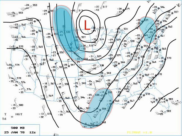
The phasing of two distinct jet streams aloft proved to be the key as to the subsequent strength and massive extent of the storm. A very strong and energetic Arctic impulse surged almost due south and plowed the Arctic front through the Northern Plains late on the 24th. At the same time, another very strong upper wind impulse surged south through southern Arizona. These two jet streaks made up the larger North American jet stream as a huge upper ridge of high pressure along the West Coast of the U.S. diverted the powerful Pacific Jet north into Northern Canada. This northern jet (containing a wind max of 110 knots) then dove due south, like on a giant roller coaster, across the western U.S. as the second, subtropical jet (with an even stronger wind max of 130 knots) surged across southwestern states. On Wednesday (25th), a deepening area of low pressure made its way east across the Gulf States into Georgia by evening (surface | 500mb). Meanwhile, across the north, the Arctic front barreled east across the Upper Midwest into the Western Lakes by Wednesday evening.
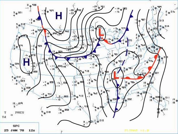
Earlier that Wednesday morning, the Winter Storm Watch for Southeast Lower Michigan was changed to a Heavy Snow Warning, while a Travelers Advisory was issued for Western and Northern Lower Peninsula. Later, at the issuance of the evening forecast, the entire Lower Peninsula was upgraded to a Heavy Snow Warning. Meanwhile, a rapid deepening of the surface low over the southeast portion of the country also commenced on Wednesday evening. As the low intensified over Alabama and Georgia, Atlanta registered its lowest barometric pressure ever late on the 25th. At the same time, further north in Michigan, snow was falling over much of the Lower Peninsula. In and around the Ann Arbor and Metro Detroit, the snow mixed with or changed to light rain Wednesday night as slightly warmer air surged northwest 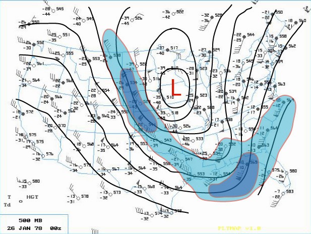 into that area ahead of the deepening storm. While the storm was organizing in the lower levels of the atmosphere over Georgia, the Subtropical and Arctic jet aloft began to merge and phase over the Southeast part of the country. This merging of jet streaks contained a wind max of 150 knots which helped induce a rapid intensification of the Georgia Low as it surged northward into West Virginia early on the 26th. Record low barometric pressures were set all along its path as an ominous track (trough) began to materialize toward the Eastern Great Lakes.
Bands of heavier snow spread north into much of Southern Lower Michigan during the very early morning hours of the 26th. Rain continued to fall, however, over the extreme southeast corner of Lower Michigan. At 1 AM EST, rain was observed at Detroit Metro Airport with the temperature comfortably above freezing at 36 degrees. Further north at Flint, however, sleet and freezing rain were falling as the temperature hovered around freezing. Air pressure tendencies were noted as falling rapidly /PRESFR/ and continued that way for several hours (in fact, several stations in this storms path had to re-adjust their barographs for station pressures traces that were BELOW initial chart scale).
The aforementioned Arctic cold front that was across the Western Great Lakes advanced steadily east into Lower Michigan as the main southern low underwent explosive deepening (this low’s central pressure fell 40 millibars in 24 hours)! The central pressure was recorded at 28.28 inches as it tracked north across eastern Ohio, just west of Cleveland, at 7AM EST. As the low moved out over Lake Erie, the Arctic cold front over Southeast Lower Michigan was pulled sharply east into it’s mammoth cyclonic circulation. Any residual rain over Southeast Lower Michigan quickly changed to heavy snow and blowing snow during the pre- dawn hours of the 26th. As the Arctic front plowed through the Cleveland area, the wind gusted to an incredible 82 mph! As the Arctic air flooded the Cleveland area, the temperature dropped from a relatively balmy 44 degrees at 4AM EST to a bitterly cold 7 degrees by 1000 AM EST.
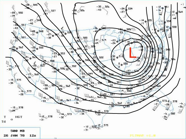
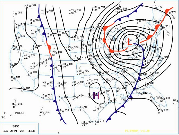
Blizzard Warnings were hoisted across much of the Great Lakes and Upper Ohio Valley Region by daybreak Thursday. The center of the huge storm (surface | 500mb) continued to trek north northwest across Southwest Ontario (roughly between Chatham and London) while Detroit measured its lowest pressure reading at 28.34 inches at 650 AM EST. The incredibly deep center made its way north along the St. Clair River with Sarnia ON reporting the lowest pressure on land at 28.21 inches. Not only was the depth of this mammoth storm’s center very impressive, so too was the extent of low pressure from its center. Even locations that were far removed from the storm’s center also reported record low pressures. Stations such as Cincinnati OH, Rochester NY and Toronto ON and even as far east as Wilmington N.C., all recorded record low pressure readings from this monster. In fact, at Toronto, where records go back as far back as 1840, the lowest pressure reading of 28.40 inches broke the old record of 28.57 inches by 0.17 inches. In addition, dozens of other cities, with records going back a century, also recorded their lowest pressure reading of all time or, for at least the month of January. This massively intense storm was responsible for strong wind gusts as far away from the center as Boston /72 MPH/ and Chesapeake Bay Bridge /90 MPH/ with even damaging winds reported as far south as Tallahassee FL.
As the Arctic air circulated throughout the storm while it made its way over Lake Huron, the lowest pressure was reached around 950 millibars or a hurricane-like 28.05 inches! “A Great Storm is Upon Michigan” read the headline of the 800 AM EST Special Weather Statement issued by the National Weather Service Forecast Office in Ann Arbor that Thursday /26th/ morning. Heavy snow and blizzard conditions were extensive as wind gusts in excess of 35 mph whipped the snow into huge drifts across much of Southeast Lower Michigan. Other areas of Eastern Michigan, Indiana and Ohio reported near hurricane-force winds, heavy snow and temperatures hovering between zero and 10 above, resulting in extreme blizzard conditions. These conditions later expanded further east into Pennsylvania and West Virginia and prevailed into the night (26-27th) across much of the Eastern Great Lakes, Southern Ontario and the Upper Ohio Valley. With the storm generating copious amounts of snow and very strong winds, whiteout conditions were widespread. All land and air traffic came to a stand still in the affected regions. Several major roads were closed for at least two to three days, if not longer, while clean up got underway. Numerous NWS employees were stranded at work, home, or on the road somewhere between the two. Several employees worked double shifts into at least Friday (some longer) because of the impassable roads with others simply unable to get to work.
The Blizzard Warnings were allowed to die across Michigan during the forenoon hours of Friday, the 27th. Record 24 hour snowfall totals from the storm included, 16.1 inches at Grand Rapids, 15.4 inches at Houghton Lake and 12.2 at Dayton, OH. Snowfalls for the entire storm (25-27th) included a whopping 30.0 inches at Muskegon (some of which was Lake Michigan enhanced), 19.3 inches at Lansing and 19.2 at Grand Rapids. Snowfalls were less over Southeast Lower Michigan (mainly because of the rain that fell for a period) and included 9.9 inches at Flint and 8.2 inches at Detroit.
The following is a quote from the summary written about the storm by Meteorologist in Charge, C.R. Snider on January 30th, 1978 at the National Weather Service Ann Arbor:
“The most extensive and very nearly the most severe blizzard in Michigan history raged throughout Thursday January 26, 1978 and into part of Friday January 27. About 20 people died as a direct or indirect result of the storm, most due to heart attacks or traffic accidents. At least one person died of exposure in a stranded automobile. Many were hospitalized for exposure, mostly from homes that lost power and heat. About 100,000 cars were abandoned on Michigan highways, most of them in the southeast part of the state.”
The employees of the National Weather Service Forecast Office in Ann Arbor had just set up shop at the new quarters at the Ann Arbor Federal Building a WEEK before the storm hit. The forecast staff had transferred from the Detroit Metropolitan Airport Office while the observing and radar staff remained at the airport. The majority of employees still lived in and around the metro Detroit area and all major roads between Detroit and Ann Arbor were blocked for approximately 18 hours due to the storm. Several employees put forth efforts beyond the call of duty, stated Mr. Snider in his storm report.
Yet, as mentioned earlier, the Winter was not yet over by any means as the month of February (after the storm) was brutally cold across much of country. The below normal temperature departures of February 1978 were strikingly similar to that of January 1978 (and in some places, February was actually colder). The average temperature for Detroit that winter came in at just 20.5 degrees /normal 27.1/ which again, made it the seventh coldest winter on record. Snowfall totaled a hefty 61.7 inches which made the winter of 1977-78 the nineth snowiest winter on record at Detroit. Flint’s average temperature of 19.1 degrees made it the fifth coldest winter on record, but Flint received less snow than Detroit with 50.6 inches. Saginaw’s winter average temperature of 17.9 degrees made it the sixth coldest winter on record and was accompanied by 55.6 inches of snow. The 1977-78 snow season at both Flint and Saginaw has since dropped off the top 20 snowiest winters list.
Single digit lows tonight Great Scotty we call this great ice making Weather…..INDY
The GFS is still on bears! Bring it!
http://wxcaster.com/gis-gfs-snow-overlays2.php?STATIONID=GRR
GFS did great on yesterdays storm I’m thinking Winter Weather advisories coming again …INDY ..
Yes it did especially when it was a couple days out.
The cpc shows a snowy 2nd week of February! Bring it!
Let it back loaded Winter ….INDY
Rock n roll will never die!
I still think the weekend storm does have some potential. Maybe another 3 to 5 inch event, if all goes well! I love back loaded winters!
January has been a fabulous Winter month no thaw no 50’s no rain just cold and snow who would of thought?? It’s a winter wonderland out there today get outside and enjoy it ….INDY
Cold and snowy? LOL That’s rich. We are extremely warm and well below average snowfall for January.
No doubt INDY! I have been skiing and snowshoeing for weeks on end and no change is in sight!
Rocky The Covid super spreader.
Great news, by the end of next week it will turn colder and snowier again! I love back loaded winters! Meanwhile enjoy this great winter weather! I will be heading out for a fantastic snowshoe hike today! It couldn’t be better!
“Back loaded winters” with below average snow every week and very mild. I love short winters!
Back loaded winters means winter is well over halfway done before it even gets started! If winter is only February and March with a couple inches of snow here and there and temps in the 30’s, I’ll take that every winter!!
CPC guesses are slightly above normal temps with above-normal precip – it will be interesting how this plays out – could be a mixed bag, perhaps an ice storm (?). yuck!
Once again we need the storm track to move to the North just like with the last storm!
http://wxcaster.com/gis-gfs-snow-overlays2.php?STATIONID=GRR
WOOD says it’s going south of GR this morning. What happened to your 5-day map showing almost a foot of snow for GR? Whoops! LOL
http://wxcaster.com/gis-gfs-snow-overlays2.php?STATIONID=GRR
The snowfall total at the GR airport was joke and is not accurate! Most of GR received 4 to 5 inches of SNOW!
We are supposed to get around 5″ of snow every week this time of year. That means, despite all the hype, this week may well be another below average snowfall week this winter.
At this time, it’s hard to say what happens with the weekend precipitation, but NWS GR is thinking most of it goes south of GR right now.
I remember both the 1967 and 1978 storms well. In Bay City the 1967 storm was as big or even bigger than the 1978 storm. In the l967 storm we were snowed in for 5 days and we lived in town. I was high school at the time and we did not have school for 8 days. That was unheard of at that time. In 1978 I was in Ann Arbor the day before the storm. I left AA around 5:30 PM the forecast was for heavy snow and it was snowing when I left AA. (Note I lived in… Read more »
We ended up with just under four inches yesterday, so well done mets. Eight degrees here right now, which is just the 1st time being in the single digits this winter.
We are still ahead of GR for snowfall this winter, which is remarkable. 🙂
I would not be surprised if there is a big storm either sometime this winter or next winter. As we are “overdue” and not to mention a ice storm is also something to watch for.
Slim
Thanks for that, Michael :0 If this keeps up, snow lovers may have to start “wintering” on Mt. Washington, the Sierra mts., or Alaska to get their fix!
I would not be suppressed if there is a big storm either sometime this winter or next winter. As we are “overdue” and not to mention a ice storm is also something to watch for.
Slim
As has been pointed out the official snow fall at Grand Rapids yesterday was 2.8″ That brings January’s total to 7.7″ and for the season 13.0″ and that is still 33.9″ below average last year as of this date Grand Rapids had 32.5″ For the month the mean temperature at GR is now 29.2 and that is a departure of +4.8. Grand Rapids is still on track for one of its lowest seasonal snow fall totals.
Slim
Thanks for the good read today on the ‘78 blizzard MV! I was young but remember it well. Something tells me yesterday’s “great storm” of 2.8” is not going to make the weather history in the years ahead. A lot of people just don’t know what an actual snowstorm is like anymore.
Temps look much warmer next week and into February. Another winter where we don’t see any cold air?
Only 2.8” of snow yesterday. GR is still more than 10” below average snow for January and still almost 3 feet below average overall.