We have our first frost and freeze this morning around the area. we have 32.4° here at the station in Otsego, Plainwell is at 31°, Kalamazoo 34°, 31.5° in Grand Rapids, 32° in Lansing, and 29° in Big Rapids – these are 5:30 am temps.
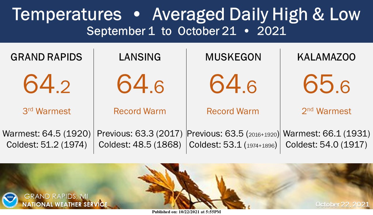
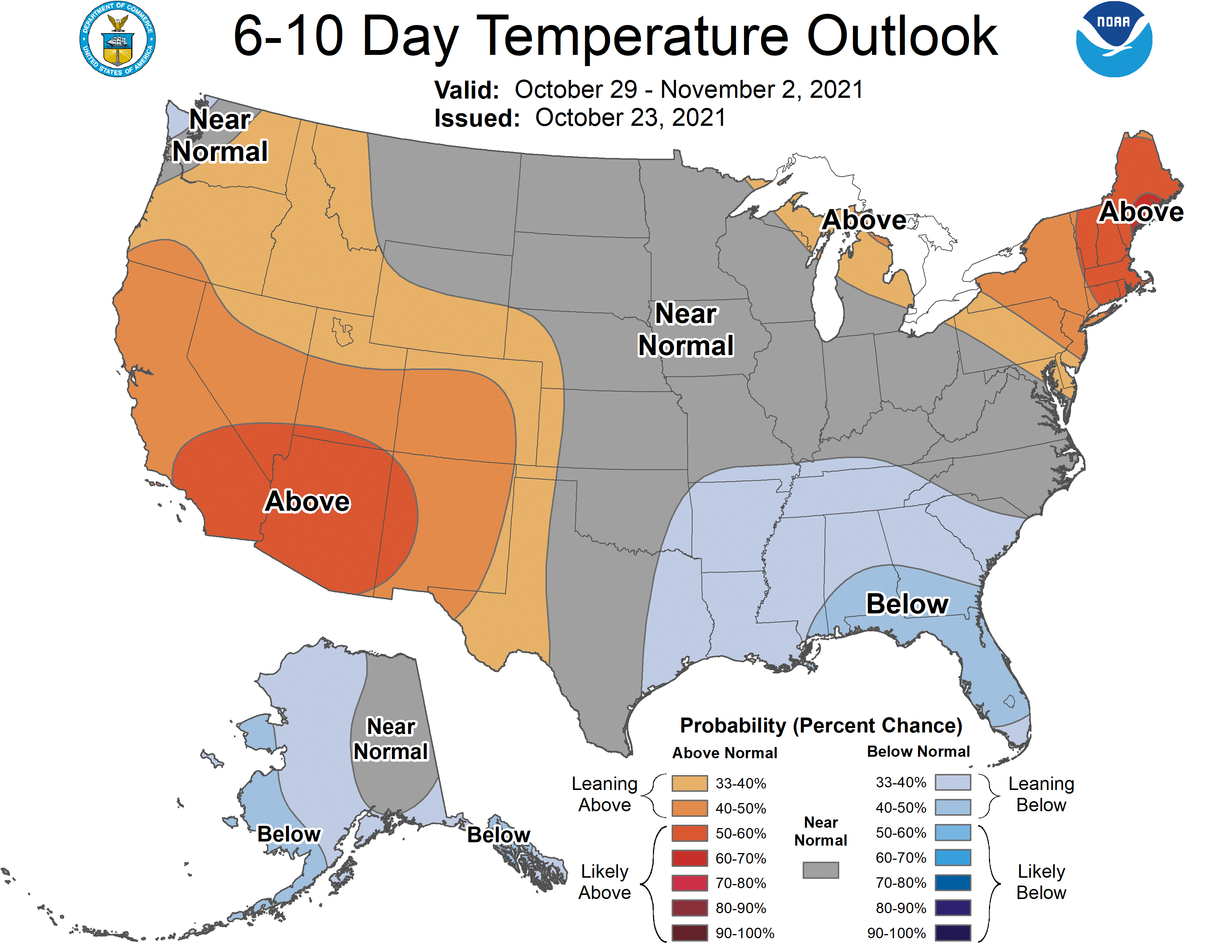
Climatological autumn runs from September 1 through November 30. Through September and three weeks of October, temperatures have averaged out to be among the warmest on record, if not breaking the record. Nightly low temperatures in particular have been much warmer than usual. Now cooler air is in place for the weekend, and some locations may see their first frost of the season.
Yesterday’s high temp was 54° and the low was 36°. Friday’s rainfall total was .08 which brings us to 3.76 inches for the month and 5.92 for the fall season thus far.
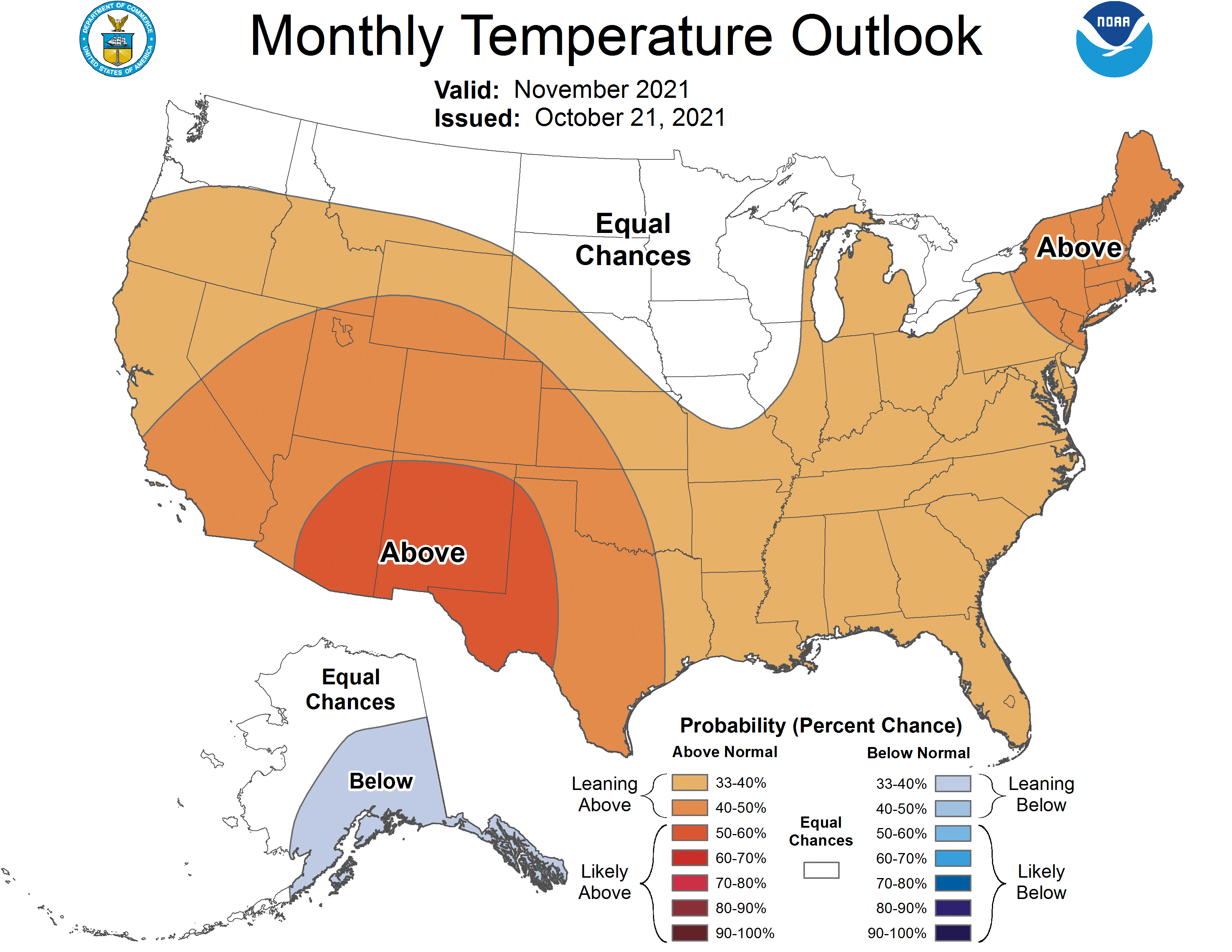
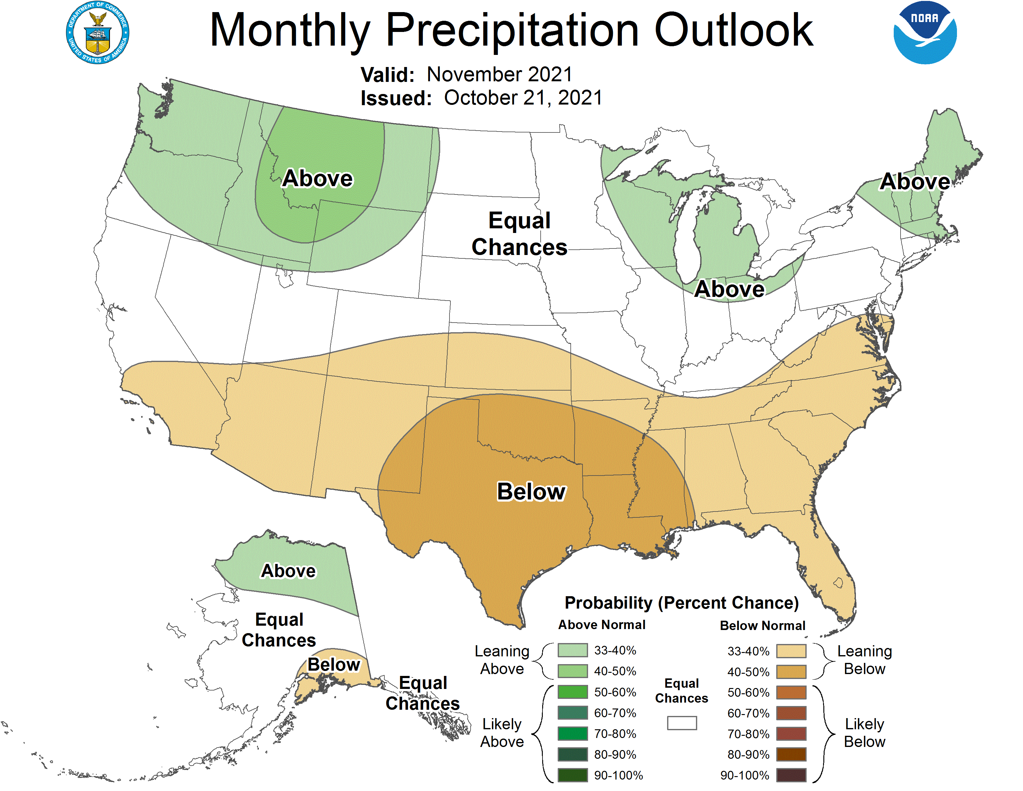
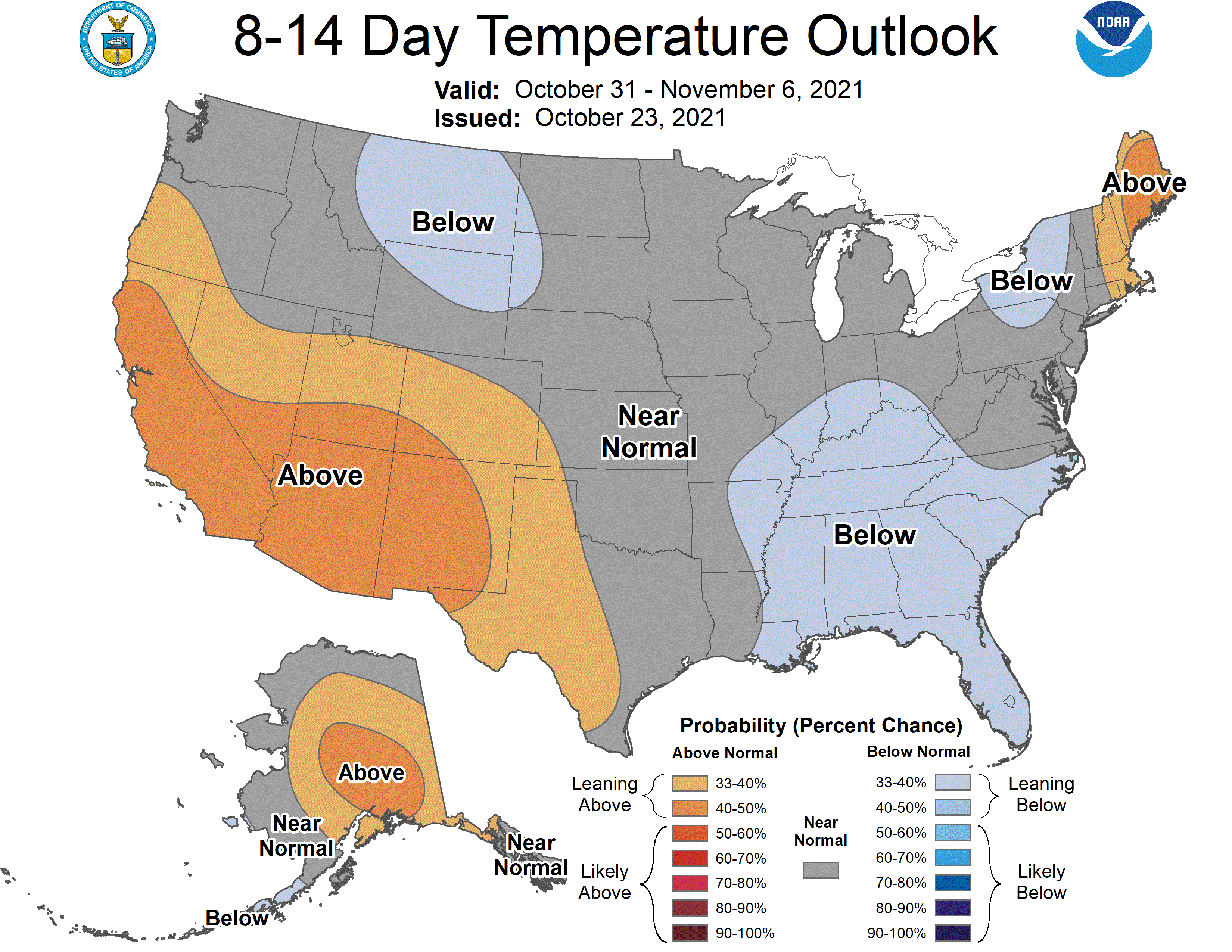
Looking at the CPC guesses for the next few weeks and November we do see a trend towards more normal temps. There is a 33 to 40% chance of above-normal temps which in my mind could wobble either way. Here is the ‘official’ NWS winter outlook.
[columns] [span6]
[/span6][span6]
[/span6][/columns]
[columns] [span6]
[/span6][span6]
[/span6][/columns]
Forecast Discussion
Heavy rain event across southern Lower Michigan tonight into
Monday. QPF over 2 inches possible across southern zones with an
inch or more across the central forecast area.

Plains cyclogenesis occurring as a shortwave trough moves out of
the larger scale troughing across the western CONUS. Surface low
tracks south of Lower Michigan tonight into Monday with an area
of strong mid-level warm advection and frontogenesis moving
across our area. There is some elevated instability as well along
and north of the surface warm front so embedded convection is
possible across the far southern zones overnight, which would
enhance rainfall rates/totals.

Shortwave ridging follows for Tuesday into Wednesday then another
chance of rain arrives by Thursday as warm advection pattern with
return flow moisture arrives ahead of approaching surface low. The
trend here has been for the low to be slower and further south
with rain persisting into the weekend.
Meanwhile, way out west:
…WINTER STORM WARNING REMAINS IN EFFECT UNTIL 11 PM PDT MONDAY
ABOVE 8000 FEET…
* WHAT…Heavy snow above 8000 feet. Additional snow accumulations
up to 48 inches. Winds gusting as high as 65 mph.
* WHERE…Portions of the Sierra Nevada from Yosemite National
Park to Sequoia National Forest.
* WHEN…Until 11 PM PDT Monday.
Only made 48* degrees in my area today it felt fantastic outside ….Get ready for more rain its on the way ..InDY
Lots of frost this morning in my area felt fresh outside….Look for plenty more on the way …INDY
Close, but no frost here either. Final week of October and still waiting for that elusive first freeze. That doesn’t happen very often.
Extremely foggy last night as I was driving home around 9:30PM, probably the worst visibility I have ever driven in. I think with the air temperature in the 30s and the very warm ground condensation fog developed.
Also I notice the temperature got below freezing at the airport. Definitely cooler than I was expecting (I was thinking upper 30s minimum)…however with clear skies in late October the temperature can definitely drop below expectations.
34 here. No frost, but super duper foggy. Prolly the foggiest I’ve seen in a very long time. Pretty cool sight – the ghostly silhouettes of the trees in the misty air.
It is foggy and 35 here at my house. I went outside and there is no frost here in my neighborhood. However at GRR they report a temperature of 31 with freezing fog. There was yet another 0.13″ of rain fall here yesterday most of that came in a heavy lake effect rain shower.
Slim