The weather is settling down today and the roads are improving. We traveled to my stepdaughter’s house east of Planwell yesterday and the roads were in fairly good condition. With the exception of the wind, this storm underperformed the November storm by about a foot of snow in the Otsego area.
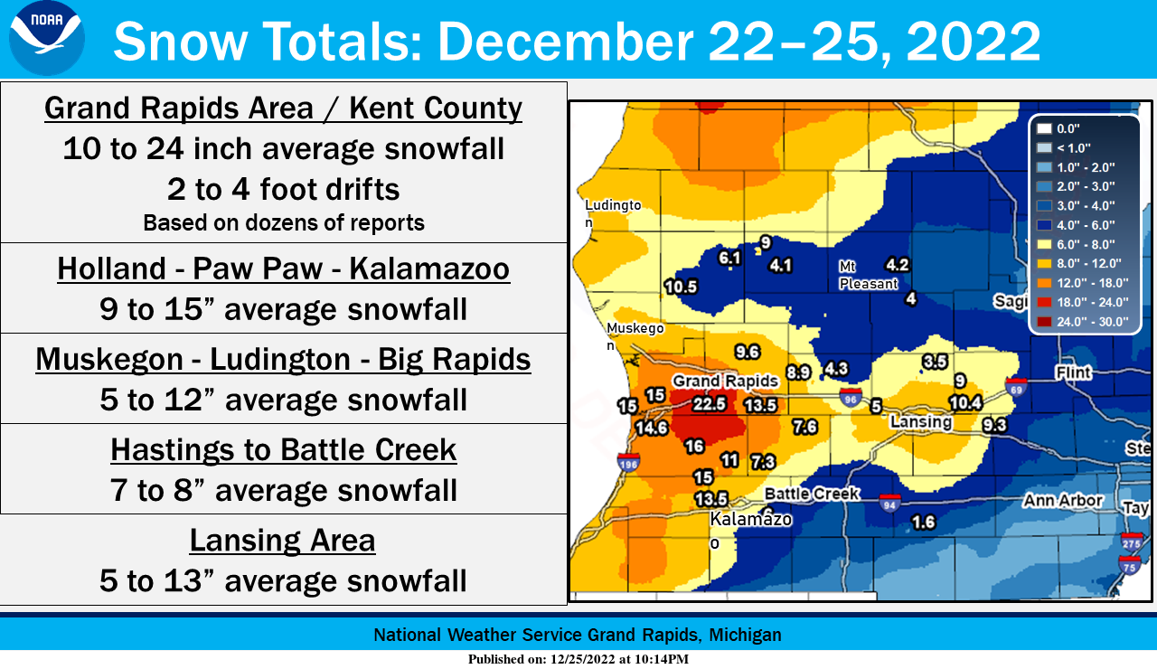
Drifting snow during blizzard conditions naturally makes it difficult to precisely measure newly fallen snow. Based on the many reports that have been sent in, it appears that the December 22 to 25 snow totals fell into roughly these ranges when averaged out, with some higher drifts. Frequent wind gusts of 35 to 45 mph (a few gusts to 55 mph) were recorded on December 23 with quarter-mile visibility or less especially in West Michigan downwind of Lake Michigan, and temperatures were in the single digits to teens.
Lansing Forecast
7-Day Forecast 42.71°N 84.57°W 12 26 lanGrand Rapids Forecast
7-Day Forecast 42.96°N 85.67°W 12 26 grrKalamazoo Forecast
7-Day Forecast 42.31°N 85.67°W 12 26 kzoForecast Discussion
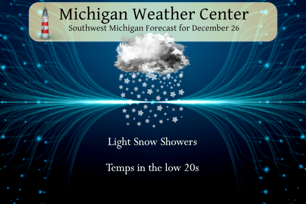
- Light Lake Effect Snow Showers Today

Upstream moisture feeds into the region this morning and afternoon
as regional water vapor imagery shows a compact midlevel shortwave
diving southeast from MN/IA into IL. While the surface feature
(~1015mb low pressure system) will stay south of us, the mid level
moisture in association with the system will move over the lake.
There will be very weak 925mb/850mb flow over the water and also
weak sfc winds over the water and land. NAM12 and RAP13 1000mb-850mb
omegas do show an area of higher values between I-96 and I-94, west
of US 131. CAMs are showing light snow showers developing this
morning and continuing into this evening, mainly for the lakeshore
region, but some activity may move inland as well. Bufkit overviews
indicate the area from BIV to LWA has the most favorable vertical
profiles wrt moisture depth and lift below and just into the DGZ.
Could be some bursts of moderate snow showers in that area. In
general, an inch or two of snow is possible near/west of US 131 with
very little east of there.

- Big Pattern Change Coming With Warmer Temperatures and Rain

Quiet conditions are expected Tuesday into Wednesday. By midweek,
upper level ridging will be building in earnest and 850mb
temperatures will begin soaring above 0C. Model guidance continues
to indicate temperatures in the 40s will arrive Thursday and
possibly remain there into the weekend. As these temperatures rise,
so will the dew points, which will also reach the 40s. This combo of
warmer temps and higher dew points for a few days will erase a large
amount of the snow pack out there.

The warmer temps are one part of the story. The other is a switch to
liquid precipitation for a change, with ensemble guidance heavily
favoring rain as the dominant precipitation type late this week and
into the weekend. Although some rain showers are possible as early
as Thursday, ensemble guidance is favoring the period from Friday
into Sunday for precipitation as one or more shortwaves pivot
through, allowing low level jets to tap Gulf of Mexico moisture. ECE
mean PWAT values for this period are showing 200% of normal. Also,
ECE probabilities for over a half inch of rain are 60% or higher
near and south of I-96. Assessing all three major ensemble suites
(ECE/GEFS/CMC) shows generally a 20%-40% potential for 1" or more of
rain through the weekend. Across central Lower MI, there may be some
risk for freezing rain at night as any of these systems move
through, depending on surface temperatures.
It is STILL snowing here, pretty incredible. The season total is almost to 70 inches!!
I’ve debated moving to the Buffalo Southtown of Hamburg before. I could easily transfer with the job I have. Maybe one day. I love western NY state.
In discussing this years Blizzard one storm that has been missed is the one in January of 1999. Here is some information on the storm “On the 2nd of January…intense low pressure was located over northeast Arkansas and slowly moved north-northeast into northwest Indiana by late evening. Snowfall rates of 1 to 2 inches per hour were common throughout the day with even heavier snow noted as the surface/mid and upper level systems wrapped up and became closed off over northern Illinois that evening. Nearly all the snowfall across northern Indiana…southern Michigan and northwest Ohio was due to the tremendous… Read more »
I was pretty young at that time and personally don’t remember the 1999 event.
You are right in stating below that not many remember the 1999 storm as I don’t recall it either. Same with this event that just happened, I don’t think in a few years many will remember this one either as there just wasn’t much memorable about it when compared to the 78 storm.
Main thing that will be memorable is that this storm occurred on Christmas. But agreed- felt more like a typical winter storm than a historic blizzard
Here’s more on the Buffalo lake effect
The article says 17 fatalities. Very sad.
https://www.accuweather.com/en/winter-weather/deadly-lake-effect-blizzard-buries-buffalo-in-nearly-4-feet-of-snow/1429773/amp
This 2022 blizzard was definitely one of the bigger events in a while around here. The difference is the 2022 one was mostly lake effect rather than synoptic like 2011 or 1978.
Speaking of lake effect the Buffalo area was pounded again
Here in GR this storm was very much like the one in 1999. And it looks like a lot of people have already forgotten about that one. Who will remember this one?
Slim
I do not recall the ‘99 storm.
I will say the 2022 storm was a longer duration, so more spread out, but 4 to 5 drifts have been reported and almost 2 foot of snow! Wow, wow!!!
According to the NWS, the 2022 blizzard had more snow, colder temperatures, and longer lasting blizzard conditions than the 1978 blizzard. Winds in both storms were about the same. Thankfully we have better infrastructure to clear the snow… but in terms of the weather conditions of both storms, the 2022 blizzard was actually worse:
Snow 1978: 19.5
Snow 2022: 24.5
Peak wind 1978: 46mph
Peak wind 2022: 45mph
Hours of blizzard conditions 1978: 5
Hours of blizzard conditions 2022: 12
Average temperature 1978: 24F
Average temperature 2022: 15F
However, to add to this: the 78 blizzard had lower pressure and was way more widespread in terms of snowfall. I think it can still definitely be argued that the 78 blizzard was worse.
The 1967 and 1978 storms were much worse than the 2022 storm. Now I will say I did not live in the Grand Rapids area in 1978 or 1967 but in Bay City while the storms were mostly “warmer” than meant the snow was more dense and thus harder plow and move. This storm for the most part had light fluffy snow0 As for the winds while it was windy in the past event and the winds were of longer duration they were nothing like either the 1978 or 1967 or even the March 1973 storms in Bay City with… Read more »
Yes it is hard to compare a lake effect storm vs a synaptic storm. This data is just a handful of statistics for Grand Rapids that the NWS posted.
And agreed, the snow was fluffy, it was spread out in duration, we (I would assume) have better means to clear roads, and it was lake effect.
It’s just interesting that if you look at the data for Grand Rapids, it actually has several metrics that were worse than 1978
One would say ya had to been there. I was trapped in northeast Martin with my then fiance during the 78 blizzard. M118 (now M222) was completely drifted shut. All the back roads were drifted over with heavy deep snow drifts. We had to walk/crawl a quarter mile to get to the horse barn we rented to feed the horses twice a day. Being young it was more like an expedition rather than a pain. US 131 was closed for several days and the National Guard was called out for assistance with their 6 x 6 trucks in the cities.
Hard to argue with facts and raw data! This was a record breaking storm! Clearly the 2022 storm was worse than the 78 storm for GR, but the 78 storm was more widespread! Facts are facts people?
I guess it depends on where you live. I don’t think the two are comparable. The impacts of ‘78 were much worse. In ‘78, we had six foot drifts and the city of Lansing was essentially paralyzed and shut down for five days. I was sick and my pediatrician made a house call via snowmobile. I still have the photo of him when he arrived. At no time this weekend could we not get out of we wanted/needed.
I agree with Mark, the two are not even comparable. The 78 storm, no body went anywhere for days, it was simply impossible. This event there was never a time we couldn’t get out. In 78 it took about 4 days just to get Chicago Drive open, this event there were cars going by the entire time. We have pictures from 78 of us walking up a drift in front of our house onto the roof, about 10 feet tall. Tallest drift I could find from this event was about 3 foot. I’m not sure I would even rank this… Read more »
Good points, Barry. So many cars were stuck, buried, and abandoned on the freeways. The National Guard was activated to assist with rescues. That alone demonstrates how much worse ‘78 was. Don’t get me wrong, this was a memorable storm. ‘67 and ‘78 set the bar, and we have not seen anything like that since.
I hope everyone had a great day yesterday. We remained in our PJs all day. It was relaxing and very enjoyable. I have no idea how much snow we rec’d, but it was a decent amount (8? 10? 12?). One side yard is almost bare and the other side has a bunch. I do know that the forecasters were really good with this storm. As advertised, we only received a couple of inches of synoptic snow, and most of our snow was of the LE variety over several days. I am still amazed at the strength of the wind and… Read more »
The official H/L yesterday at Grand Rapids was 19/14 there was 0.08” of precipitation that fell as 3.7” of snow. There is now officially 17” of snow on the ground at GRR here in MBY I have 18” on the ground. That official snow depth of 17” is the 2nd most for any Christmas morning in Grand Rapids with only the 22” in 1951 being more. Here in my yard the overnight temperature held steady at 19 the official low at GRR was 17. For today the average H/L is 34/22 the record high of 61 was set in 2019… Read more »