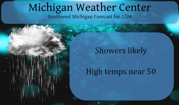
I spent a couple of hours outside enjoying the sun yesterday, we reached 52° which felt warm after the sub-freezing temps we had been experiencing. We will still be near 50 today though the sun will be covered and we will see some rain and drizzle around the area to close out the month of February.
Below is the anticipated article from NOAA pertaining to the production of new climate normals coming soon:
NOAA will soon release a much-anticipated update of U.S. climate data for placing recent weather conditions—such as heatwaves and flooding rain—into historical context.
This new 30-year dataset will span from 1991 to 2020 and is scheduled for release in May 2021 Climatologists from NOAA NCEI are currently compiling and reviewing 30 years of weather and climate data from across the U.S. to serve as the nation’s updated climate “normals” for the next 10 years. This new 30-year dataset will span from 1991 to 2020 and is scheduled for release in May 2021.
What Are Climate Normals?
Traditionally, scientists define climate normals as three-decade averages of climatological variables. The current batch of 30-year Climate Normals developed and used by NOAA covers the period from 1981 to 2010 and is calculated from observations at approximately 9,800 stations across the U.S. operated by NOAA National Weather Service.
“NOAA’s Climate Normals provide a baseline to compare yesterday’s weather and tomorrow’s forecast to a standard for each location and time of year,” said Mike Palecki, project manager for NOAA’s 1991 to 2020 Climate Normals. “They can be used to understand the impacts of climate on many activities such as agriculture decision support, electricity load planning, building heating requirements calculation, construction scheduling, and many other factors impacting all sectors of the economy.”
Why is 30 years considered the standard? In 1935, the International Meteorological Organization—now known as the World Meteorological Organization instructed member nations to calculate climate normals using a 30-year period, beginning with 1901–1930.
NOAA scientists produce traditional 30-year Normals that meet this international convention, but they have also provided other reference time periods as needed. For example, time series for climate change studies are often compared to a more-lengthy 1901–2000 average set, and supplemental normals for shorter periods are also provided.
Calculating the New Climate Normals
Palecki emphasized that NOAA’s Normals are rather complicated sets of calculations, not just simple averages. These calculations fill in missing data using surrounding weather stations and ensure that daily Normals match monthly Normals. They also remedy discrepancies that might arise when stations change locations.
In this next round of Climate Normals, new things will be added—including several small changes to how NCEI calculates them.
“Our main methodologies have not changed since the last Normals cycle,” Palecki said. “But minor improvements have been made in how we round numbers, calculate percentiles, count the numbers of days exceeding thresholds, and format output.”
For the first time, this updated batch of Normals will include 15-year Normals for those needing a climatology representing a period closer to today also, for the first time, this updated batch of Normals will include 15-year Normals for those needing a climatology representing a period closer to today. NOAA will also release high spatial resolution monthly Normals data for the conterminous U.S., as well as develop new tools and methods to access the data.
“These new Normals are a better baseline for today’s climate, helping inform activities in many economic sectors,” Palecki added. “Interestingly, this shift will result in there being fewer ‘above normal’ temperature days in most of the U.S. at the start of this decade compared to recent years that used the previous Normals cycle. Climate will continue to change in the U.S. during this decade, however, so we will need to do this again in 2031.”
Once the new NOAA Normals are released in May 2021, they will be available to the public from NCEI.
Forecast Discussion:
- Warmest Day of Year yet with showers and breezy

With high temperatures forecast to get near 50 degrees near and
south of I-96 this afternoon, and considering so far this year,
our highs afternoon temperature have only made it to the lower
40s, there is little question today`s high temperature near 50
will be the warmest of the year to date. It is typical with a
system like (occluded low tracking north and west of GRR), for us
to get a surge of warm air just ahead of the front. MY 1000/925
thickness tool gives me 48 at GRR today.

We were concerned about freezing drizzle but the low levels do not
get saturated as quickly as we were thinking they would earlier.
The latest run of the RAP model does not get the 98% mean relative
humidity in the 1000 to 900 mb layer to I-96 till 9 or 10 am this
morning. By then all areas should be above freezing so I do not
think freezing drizzle will be much of an issue after all.

There is an area of fog, which is locally dense north and east of
Grand Rapids. That should be pushed northward as the system gets
closer to this area and brings stronger low level winds with it.
More fog will develop today as the warm front pushed into our
area mid to late morning. That should not be dense fog through.

As for precipitation today, expect showers this afternoon. There
are at this point two primary areas of precipitation (talked
about in our afternoon discussion) associated with this system.
Both of those will miss us. However, a third are is expected to
develop just ahead of the occluded front by late morning and then
move across Southwest Michigan into late this afternoon.

As it turns out, the core of the upper jet is over Michigan this
afternoon and remains near us into this evening. The upper jet
core strengthens from 130 knot to near 170 knots between early
afternoon and mid evening, while the core of strongest winds
remains over northern Lower Michigan during this time. In response
to that, the low level jet also strengthens. It has forecast
max wind speeds around 35 knots north of HTL by mid morning. Then
by 4 pm, the highest wind speeds with the Low Level Jet increase
to around 55 knots just off shore of Alpena. At that point there
should be with an axis of 45 knots winds from MKE to PLN. Add to
that mid level instability (lapse rates near 700 to 500 mb will be
over 8C this afternoon). The TQ index gets to 18c this afternoon.
The 1000 to 850 LI goes negative over Southwest Michigan this
afternoon too. Beyond the the 1000 to 850 moisture transport
vectors really ramp up this afternoon, focuses on the western 1/3
of lower Michigan. So I believe in response to all of that we will
see showers develop by late morning or early afternoon just ahead
of the front. These should not be thunderstorms since the max
cape is well under 500 j/kg. This idea is well supported by our
high resolution models (all of them).

It should be noted too that the overall strength of this system is
less on the models with the overnight model run, then it was
yesterday, so advisory class wind gusts are now not expected when
the polar front comes through early this evening.

- Arctic front cold with snow showers Monday

The arctic front comes through this area by early afternoon Monday
but this does not look nearly as impressive as it did the past
few day. So I do believe we will see snow showers or more likely
snow flurries with gusty winds but this should not amount to much
more then brief reductions in visibility and a few tenths of a
inch of snow. Note through that it is those sort of snow showers
that have cause the most significant accidents in the past.

- Generally warmer than normal and dry weather into weekend

Overall, we have a progressive upper air pattern that after
Monday will feature a split upper level flow. That keeps the cold
air in northern and Central Canada and the really warm air well
south of Michigan. This will also keep the storm track south of
Michigan through the week into the weekend. We should stay dry
from Tuesday into next weekend with temperatures mostly above
normal.
57 and sunny here. As you can imagine, most of the snow is gone.
50 degrees here with off and on rain. Few clumps of snow here and there, but now more grass showing than snow.
48 with on and off rain here.
Slim
I can’t remember the last winter I skied this much? Probably 4 or 5 years ago! What a winter! I love it!
With no snow in todays forecast and yesterdays official 1” of new snow at GRR that brings this February’s total snow fall to 30.6” and guess what that will make this February the 6 snowiest February at Grand Rapids. For the meteorological winter Grand Rapids will end up with just 45.4” that is about a foot below “average” and for the season so far Grand Rapids is at 45.8” and that is over a foot and a half of where GR should be going into March.
Slim
I will be waiting to see how the new official 30 year averages are my guess is that the monthly temperatures will go up and for Grand Rapids the total seasonal snow fall with also go up. As we have had snow big snow fall totals in the last 30 years here.
Slim
Today is a good case history on the amount of time that is used for a “average” H/L. Todays “normal” or average H/L at Grand Rapids is 38/22 for the record high the range is from 60 in 2018 with the coldest maximum of 20 in 2014. The range for the warmest minimum is 40 set in 2018 and the record low is -12 set in 2014. So all of the records have been set in the “new” 30 year cycle. For today using the 1991/2020 period the average high/low for this date would be 36/20 as there have been… Read more »
Absolutely great skiing and weather up at Nubs Nob! Fresh snow and all runs are open! Even the cross country trails are open and in excellent condition! It has been a spectacular winter for skiing! Let’s see some more snowstorms! My my, hey, hey, Rock n Roll will never die!