Mother’s Day is a holiday honoring motherhood that is observed in different forms throughout the world. In the United States, Mother’s Day 2023 will occur on Sunday, May 14. The American incarnation of Mother’s Day was created by Anna Jarvis in 1908 and became an official U.S. holiday in 1914. Jarvis would later denounce the holiday’s commercialization and spent the latter part of her life trying to remove it from the calendar. While dates and celebrations vary, Mother’s Day traditionally involves presenting moms with flowers, cards and other gifts.
One tradition on or near Mothers Day is heading to a local nursery and buying flowers in pots and or to plant in the yard. In looking at the weather on Mothers Day over the last few years it can be seen that it is not always been warm on the date. Here are the high/low and rain fall amounts of Mothers Day going back to 2008. From 2008 (the 11th)H/L was 57/48 and there was 0.27” of rain. 2009(the 10th) the H/L was 59/44 there was a trace of rain. 2010 (the 9th) the H/L was 59/31 no rain. 2011 (the 8th) the H/L 70/46 no rain. 2012 (the 13th) the H/L was 74/52 there was a trace of rain. 2013 (the 12th) the H/L was a chilly 46/37 no rain. 2014 (11th) the H/L was a warm 84/44 with a trace of rain. 2015 (10th) the H/L was 62/51 there was 0.41” of rain fall. 2016 (8th) the H/L was 68/41 no rain. 2017 (14th) the H/L was 73/52 no rain. 2018 (13) the H/L was 75/51 there was 0.20” of rain. 2019 (12th) the H/L was 56/44 with a trace of rain. 2020 (10th) the H/L was 53/36 and 0.21” of rain fall. 2021 (9th) the H/L was 31/37 no rain and 2022 (8th) the H/L was 37/36 and no rain fall. Mothers day falls on the 2nd Sunday of May so the dates are between May 8th and the 14th.
The official H/L at Grand Rapids yesterday was 79/55 there was just a trace of rain fall and just 10% of possible sunshine. There were 2 cooling degree days and 0 heating degree days. For today the average H/L is 69/48 the record high of 86 occurred in 1982,1991 and 2022. The record low of 27 was set in 1946. The record rain fall of 1.92” fell in 1964.
DISCUSSION
(TODAY THROUGH NEXT FRIDAY)
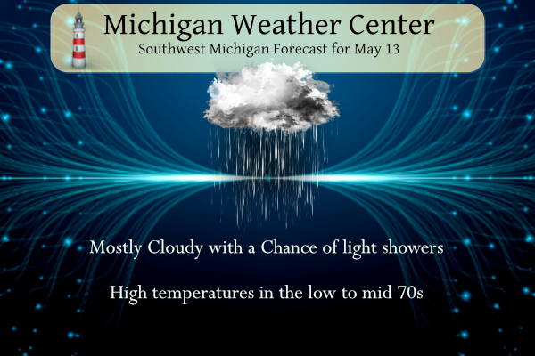
ISSUED AT 252 AM EDT SAT MAY 13 2023
– CLOUDY WITH A FEW SPRINKLES THROUGH SUNDAY
A ZONE OF UNSETTLED WEATHER ASSOCIATED WITH A MIDLEVEL FRONTAL
BOUNDARY SITS JUST TO THE SOUTH AND WEST OF LOWER MICHIGAN. THIS
WILL BE WHAT KEEPS PERSISTENT CLOUDINESS OVER OUR AREA THROUGH
LATE IN THE AFTERNOON OF MOTHER’S DAY (SUNDAY). THANKFULLY, THE
TREND OVER THE LAST FEW DAYS HAS BEEN TO KEEP THE ROUNDS OF RAIN
JUST BARELY AWAY FROM OUR AREA. WE’LL SEE A FEW CHANCES FOR LIGHT
RAIN OR SPRINKLES, BUT NOTHING THAT SHOULD RUIN ANY DAYS OR
OUTDOOR EVENTS. HIGH PRESSURE AT THE SURFACE WILL BE BUILDING INTO
THE UPPER GREAT LAKES OVER THE NEXT DAY OR TWO, CAUSING A
REORIENTATION AND STRENGTHENING OF THE PRESSURE GRADIENT OVER
WESTERN MICHIGAN. WE DO THINK THIS WILL RESULT IN SOME MILDLY
GUSTY NORTHEAST WINDS OVER THE NORTHERN SITES (ALONG/NORTH OF I-96
TODAY).
– COOLER, BUT MOSTLY DRY THROUGH MIDWEEK
BY SUNDAY, THE NEARLY-STATIONARY MIDLEVEL FRONT GETS KICKED OUT TO
THE SOUTH BY A SHORTWAVE MOVING THROUGH THE GENERALLY NORTHWEST-
TO-SOUTHEAST STEERING FLOW THAT IS IN PLACE ACROSS THE GREAT LAKES.
THIS USHERS IN A COOLER AND DRIER AIRMASS (BUT ALSO, THE RETURN OF
SUNSHINE!) FOR THE FIRST HALF OF THE UPCOMING WEEK. A TYPICAL
FEATURE OF PERSISTENT NORTHWEST FLOW IS REPEATING SHORTWAVE
TROUGHS BLASTING ACROSS MICHIGAN, AND THIS WILL BE THE CASE THIS
WEEK AS WELL. THE SAVING GRACE IS THAT OFTEN THE LOW-LEVELS ARE
TOO DRY TO RESULT IN MUCH PRECIPITATION, AND THIS IS WHAT LOOKS TO
HAPPEN ON TUESDAY AND TUESDAY NIGHT. BY THE THURSDAY/FRIDAY
TIMEFRAME, THOUGH, ONE OF THESE SHORTWAVES LOOKS LIKE IT WILL
STRENGTHEN MORE SUBSTANTIALLY (POSSIBLY INTO A WEAKLY CLOSED UPPER
LOW) AS IT PASSES NORTH OF MICHIGAN. THIS WILL PROVIDE STRONGER
FORCING AS A MORE AMPLIFIED TROUGH PLOWS THROUGH, SO WE COULD SEE
A ROUND OF SHOWERS OR STORMS POSSIBLE DURING THIS TIMEFRAME –
ESPECIALLY IF THE TIME OF ARRIVAL COINCIDES WITH PEAK DAILY
HEATING. THERE IS STILL QUITE A BIT OF UNCERTAINTY WITH THIS
SYSTEM, SO DETAILS WILL BECOME CLEARER OVER THE NEXT SEVERAL DAYS.
Detailed Forecast for Grand Rapids
Overnight
A 30 percent chance of showers. Cloudy, with a steady temperature around 63. East northeast wind around 6 mph.
Saturday
A 30 percent chance of showers, mainly before 8am. Cloudy, with a high near 76. East northeast wind 8 to 10 mph.
Saturday Night
Mostly cloudy, with a low around 54. East northeast wind 10 to 14 mph, with gusts as high as 22 mph.
Sunday
Cloudy, with a high near 64. East northeast wind around 11 mph, with gusts as high as 21 mph.
Sunday Night
Partly cloudy, with a low around 41. East northeast wind 5 to 10 mph.
Monday
Sunny, with a high near 70.
Monday Night
Mostly clear, with a low around 52.
Tuesday
Mostly sunny, with a high near 74.
Tuesday Night
Partly cloudy, with a low around 46.
Detailed Forecast for Lansing
Overnight
A 20 percent chance of showers. Mostly cloudy, with a low around 59. East northeast wind around 5 mph.
Saturday
A 20 percent chance of showers before 2pm. Cloudy, with a high near 74. Northeast wind around 8 mph.
Saturday Night
Mostly cloudy, with a low around 52. East northeast wind 9 to 13 mph.
Sunday
Mostly cloudy, with a high near 63. East northeast wind 10 to 13 mph.
Sunday Night
Partly cloudy, with a low around 39. North northeast wind 5 to 10 mph.
Monday
Sunny, with a high near 72.
Monday Night
Mostly clear, with a low around 52.
Tuesday
Mostly sunny, with a high near 75.
Tuesday Night
Partly cloudy, with a low around 45.
Get ready for the cold! Lows tonight in the 40’s and tomorrow night in the 30’s!!! The cold pattern keeps rockin! Wow, just wow, WOW! Incredible cold!
The CPC is now holding on to near to below average temperatures but it looks like it will be dryer than average over the rest of May. Could this be the trend for the summer? Near average to cooler than average and dry?
https://www.cpc.ncep.noaa.gov/products/predictions/610day/index.php
and 8 to 14 day
https://www.cpc.ncep.noaa.gov/products/predictions/610day/index.php
No “blowtorch” according to the CPC
Slim
Looks GREAT!!
We are getting a nice light rain. It is much appreciated. Yesterday I found about 40 large morels around my property. The most I have found in a single day. Delicious.
The state of Nebraska had 50 tornado warnings yesterday. That is the most ever recorded in a single day in the state.
Looks like there were a lot of warnings and a lot of touchdowns. Not much on their news of damage.
Slim
Today will be our 9th warm day in a row. Warmth just hasn’t stopped for a year now.
Also there were 13 days in a row of cold at the end of April, start of May. We generally have temperature ups and downs here in Michigan. No real long heat waves and no real long cold periods.
Slim
And yet we haven’t had a below average temp month in a year!
You are 100% wrong of course!
Get ready! Lows in the 30’s on Sunday night! The cool pattern is locked in!