We saw some sun yesterday mainly in the morning before the lake effect kicked back in again. The high was 37° and the low 28°. This is like a heatwave compared to temps in Alaska which are in the negative territory and will remain so all week, -20° to -30° forecast for this week for highs. Northern Canada is the same. This cold air mass is forecast to stay where it is, just something to keep in mind as we get into December though there are no signs this is coming here any time soon.
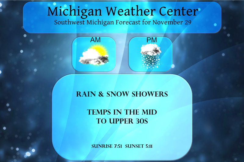
We will see some sun early before the clouds move back in today bringing in a mixed bag of precip. Some areas could see another 1 to 2 inches of snow. Any snow we get will melt off by mid-week as temps warm into the 40s.
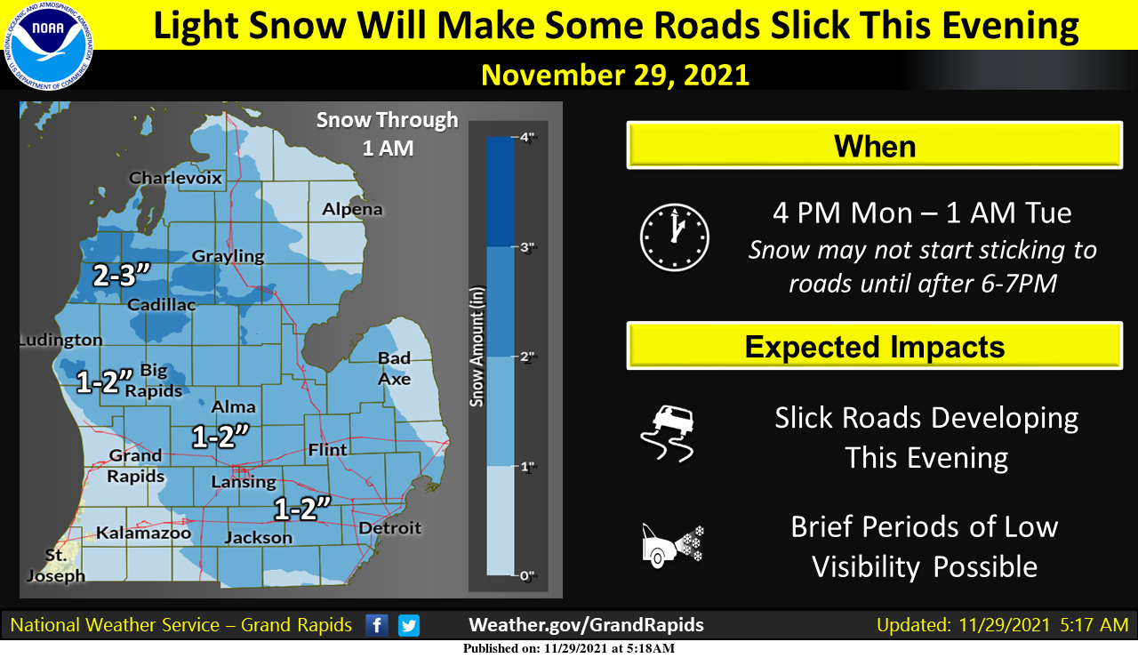
Widespread accumulating snow is expected to begin spreading into the area after about 4 PM today, but there may be a few light showers here and there before then. Much of West Michigan should see 1-2” of snow by midnight, but some higher amounts around 3” are likely. Temperatures will initially be above freezing when snow begins, and this should help keep road conditions more manageable. We may start to see slick conditions develop this evening however as temperatures fall. Any moisture left on roads overnight will freeze if not treated, and some roads could be slick for the Tuesday morning commute.

Two weather systems moved through Lower Michigan between Saturday and Sunday morning, putting down a few inches of snow first in west-central to southeast areas followed by a few inches in northern areas.
Forecast Discussion
- Light Snow To Cause Some Travel Impacts this Evening -

Next upper wave embedded within an active northwest flow pattern
will clip across the Great Lakes late today and tonight, sending an
area of surface low pressure across Michigan. Warm advection and
isentropic ascent will commence this afternoon over West Michigan,
but it will probably take a few hours for the airmass to saturate
down for accumulating snow as it will initially be dry, and early
forcing will not be too strong. That looks to change for the evening
as elevated frontal boundary slides in overhead and left exit region
forcing over the top of it prompts a decent FGEN response. Stronger
upright forcing in tandem with the arrival of deeper moisture should
allow for better precipitation rates. Forcing is centered well
within a saturated DGZ, but it is up quite high (H600+), and general
sense is that we will see steady light across West Michigan this
evening. Like the snow event from Saturday, the system`s trajectory
will allow for lightest amounts and a shorter window for snow across
far Southwest Lower. Current forecast is for a broad area of 1-2"
snow amounts roughly northeast of a line from Muskegon to Grand
Rapids to Battle Creek, with locally higher amounts possible.

High temperatures today are expected to reach the mid and upper 30s
before diurnal and wet-bulb cooling allow temperatures to drop close
to freezing in the 6-8PM time window (during snow). Impacts to roads
may be small at first given temperatures initially above freezing,
but we should start to see some slick roads developing after dark.

Moisture and forcing look to peel away pretty quick overnight, while
inversion heights crash over the lake late tonight through Tuesday
morning. Any lingering snow showers or drizzle should be light and
spotty.

- Warmer For Mid Week -

Yet another low pressure system will clip the Northern Great Lakes
Tuesday, pulling a weak cold front through the area late. This looks
to have little moisture to work with, and while we could see a few
light snow showers near/north of US 10, the main impact will likely
be modestly gusty winds and cool overnight lows in the low/mid 20s
Tuesday night. Before the front passes through, highs Tuesday should
reach the upper 30s to low 40s. Surface ridging following by a shot
of warm air advection ahead of another low pressure system should
boost highs well into the 40s for much of West Michigan Wednesday
and Thursday. 50 degree highs look within reach Thursday for the I-
94 corridor, per quite a few GFS and Euro ensemble forecast members.
May see another decent shot of precipitation north of I-96 Wednesday
along the warm front, but there is quite a bit of discrepancy within
the model solutions as to how far south into Lower Michigan this
will occur. Warming temps would allow a lot of this to fall as rain
if it does make it down this far.

Temperatures look to trend cooler again for next weekend. The active
pattern will continue, which may bring snow back into the area, but
model solutions have shown very little run to run and model to model
consistency to get too excited about anything yet.
Mondays GR snow total was a whopping 3.5 inches! Incredible November snowfall!
We have been getting absolutely hammered with snow for hours! Probably at least 2 inches already! Incredible!
Snowing heavily out in my hood love it …InDY
No way?
Looks like GR is up to 6.2 inches for the season so far. Depending on how much we get from this WWA we may end up just above/below average for the month. I think we average around 8 inches for November.
The new 30 year average at Grand Rapids is 7.1″ 6.5″ at Muskegon and 3.9″ at Lansing. The 15 year average is just 5.0″ at GR. 5.2″ at Muskegon and 3.6″ at Lansing.
Slim
We are a lock to end up with above average snowfall for the month of November! Mark it down and take it to the bank!
We saw this coming at the beginning of the month ….Below average temperatures and above average snowfall incredible is right….InDY
Let it snow let it snow let it snow….InDY
Rock n Roll will never die! It could be a winter to remember!
Pretty quiet lately on here lol….Could you imagine if it was in the 50’s Outside…Maybe mookies golfing..InDY
Mookie and Andy are golfing and Barry has his AC running on full blast!
WINTER WEATHER ADVISORY FOR GRAND RAPIDS MICHIGAN….InDY
A WWA was just issued! This is the third WWA so far and only November! How incredible is that? This could be a winter to remember! Bring it!
Compared to last year we have had 15 times more snow so far! Great start!
The snow maps and starting to show consistent snow in the long range! Who wouldn’t want snow in December?
https://www.pivotalweather.com/model.php?p=sn10_acc&rh=2021112906&fh=384
There was a trace of new snow fall here yesterday but with highs here in the mid 30 some of the snow on the ground melted and there is just one inch on the ground here this AM. There was some clearing overnight and the low dropped to 19 here the official low at GRR was 21. At this time it is 24 here with broken clouds.
Slim
More snow coming great Scottish lets see if the NWS puts put any advisorys today would not surprise me as we leave this snowy and cold November and move into a wintery December just wow I shall say ……Let it snow let it snow let it snow ….Who Knew??? InDY
Great start to winter! November = above normal snowfall and below normal temps! How is that possible when the warm weather fanatics keep saying warm and not snowy, just like last year? Incredible delusion!