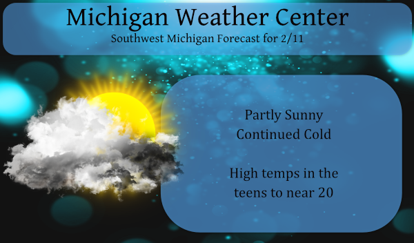
The sun may make an appearance depending on your location today. Of course with the clearing temps tend to dip lower with the Canadian air in place over SW Michigan. We still haven’t dipped below zero in our area but our best chances may come this weekend with another cold shot forecasted.
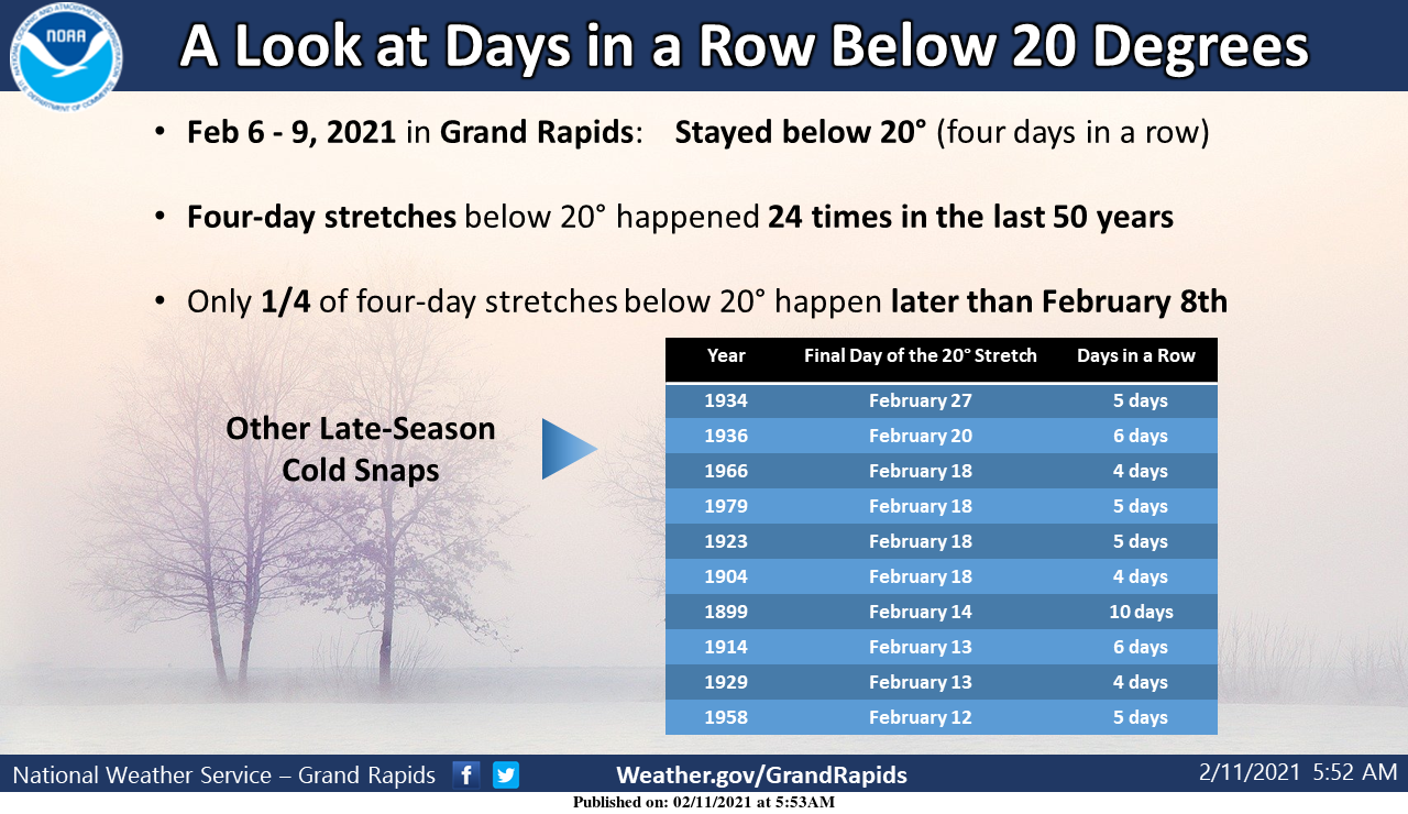
Grand Rapids had four days in a row with high temperatures colder than 20 degrees. This is not a feat seen every winter, but on average you could expect it about once every 2 years. And when it does happen, it’s usually not this late in the season.
Forecast Discussion
--Occasional light snow; remaining cold--

We have a couple of synoptic light snow events to watch through
the weekend, driven by jet streaks zipping across the nrn United
States. The first arrives tonight and continues into Friday
morning, with most of the light snow falling north of a Holland to
Lansing line. Accumulations expected to be only a dusting to one
inch, but could slicken up the roads and impact the Friday
morning commute.

During this weak synoptic event while deeper moisture is present
and low level convergence is briefly enhanced over the middle of
Lk MI, mesoscale models hint at the development of a fairly
robust N-S oriented lake effect snow band tonight. Sfc winds try
to turn NNW for a time Friday which could send this band onshore,
particularly around Ludington. This could lead to some localized
1-2" accums Friday morning before the band dissipates in the
afternoon.

Another synoptic event impacts the area from late Friday night
into Saturday and this one has a better looking shortwave with a
bit more QPF. Fcst soundings off the NAM reveal the presence of a
rather deep and moist isothermal layer which may promote dendrite
production and result in high snow ratios on the order of 20:1.
Current expectation is for a widespread 1-3" snowfall.

Even though the bitter cold air mass will linger the next several
days, the large 1045 mb sfc high centered over south central
Canada continues to generally curb/limit lake effect potential
and hold wind speeds and wind chills at somewhat tolerable levels.
Our coldest period over the next week will be Sunday and Monday
when highs of 10-15 are expected. Widespread sub-zero low
temperatures are possible on Sunday night as the center of the
sfc high nears.

--Several inches of snow possible Mon ngt and Tuesday--

Still support for a widespread accumulating snow event on Monday
night and Tuesday as broad deformation zone related to developing
east coast storm sets up for time over Lwr MI. Most of the EC
ensemble members now support accumulations from this event, but
the amounts are not particularly impressive. The ensemble mean
QPF is only around 0.25 with only a few members pushing 0.50.
Still, that supports the potential of at least a 2-4" type of
event, possibly more depending on snow ratios.
Weather History
February 7
1899: The greatest arctic outbreak in United States history begins a period of extreme cold in Michigan. Grand Rapids hits 15 below zero. During the next week, temperatures will fall to all-time record lows across the state and much of the continental U.S. (I discussed this yesterday)
February 8
1925: A four-day warm spell with highs over 50 degrees across southwest Lower Michigan peaks with a record high of 60 degrees at Grand Rapids.
February 9
1875: The temperature tumbles to 32 degrees below zero at Lansing and 20 below at Detroit during one of the coldest months on record in Lower Michigan. The mean temperature for the entire month at Lansing is 4.7 degrees, the coldest month ever recorded there.
1934: The coldest temperature ever recorded in Michigan occurred at Vanderbilt, with a low of 51 degrees below zero.
February 10
1899: Grand Rapids has its coldest day on record with a high of 6 below zero and a low of 21 below. Muskegon had set their record for all-time coldest high temperature on the 9th with a high of 5 below zero.
February 11
1899: Muskegon records their all-time record low of 30 below zero. Grand Rapids falls to 21 below and Lansing 22 below.
1999: A surge of warm air ahead of a cold front brings all-time record high February temperatures to much of Lower Michigan. February records include 67 degrees at Muskegon and 69 degrees at both Grand Rapids and Lansing. Battle Creek hits 72 degrees.
February 12
1967: Temperatures plummet to 24 below zero at Lansing and 16 below at Grand Rapids as arctic high pressure moves across Lower Michigan.
February 13
1938: Heavy rain and warm temperatures prevail for the second day. Lansing records over three inches of rain from the storm and Grand Rapids over two inches and some minor flooding is noted across Lower Michigan.
It was beautiful to see and feel the sun today!! 🙂
The 5 day SNOW maps are starting come around! Plenty of winter and cold and snow or come! Mark it down!
http://wxcaster.com/gis-gfs-snow-overlays2.php?STATIONID=GRR
Only 5 weeks of the worst season of the year left!! And the teleconnectors are pointing towards an early spring too, so possibly less than 5 weeks! Early springs ROCK!!!!
https://days.to/until/spring
Thanks for reminding me! 5 full weeks of winter left! I love it!
Well with winter just starting last week, you might as well enjoy the few short weeks that are left!
Still looking great for next week! Winter is the absolute best!
https://www.cpc.ncep.noaa.gov/
This is what I was trying to post!
Oh my gosh, it might actually get up to freezing by the end of next week! This is still below normal and is a great set up for snowstorms! We still have weeks on end of winter! Rock n roll will never die!
Looks like this short cool snap will be over soon and temps will be back into the 30’s late next week! Then just a short time til the best time of the year SPRING!!!!
https://weather.com/weather/tenday/l/b4ea0280869baa46799dc75eacef8904785ec43ad2f6fb098355fbc208a55e2c
The spring outlooks are looking FANTASTIC!!! Who knew!?!?! I’ll take 2 week winters like this one every year!
https://weather.com/forecast/national/news/2021-02-10-spring-temperature-outlook-united-states
A warm spring? I love it!
Great news – we still have over 6 weeks of winter left and all models show cold and snowy! Bring it!
-1* this morning in my area I haft to say that’s bone chilling cold for the middle of February …Looks like several shots of snow coming this weekend into next week wow just wow our back loaded Winter of 2021 fun continues ….INDY
Old snow is condensing and melting in the sun. Snowpack down from 12″ to 9″ already. A week or two and this short winter in February will be behind us. I love it!
We are having great winter weather and highs below 20 degrees are perfect for me. Fresh snow and no snow melt! Absolutely love it!
With clear skies the temperature is now down to +1° here at my house. This is the coldest so far this season here at my house. Also the snow on the ground now has compacted down to 10 inches. We are now getting to the time of the season that on sunny days the sun will melt the snow.
Slim
The sun is definitely getting stronger. I think it’s gone up from 23 to 33 degrees since the solstice.
overnight low here was 6.6 – the sun is shining now with a temp of 12.2
I did not realized that highs of less then 20 were that rare. I would have looked for the number of days with highs of less than 10 I well have to look at that.
Slim