We have now reached which is typically the warmest part of summer before we reach a faster downward trend of daylight. Today the sun rises at 6:21 and sets at 9:15 giving us 14 hours 54 minutes of daylight. At the beginning of July, sunrise/sunset times were 6:09/9:23 which gave us 15 hours and 14 minutes of daylight. By the end of the month, we are down to 14 hours and 29 minutes of daylight. By the end of August, we are down to 13 hours 11 minutes.
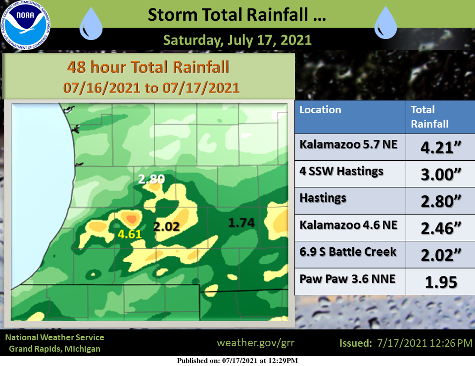
These are rainfall totals from Friday/Saturday’s system:
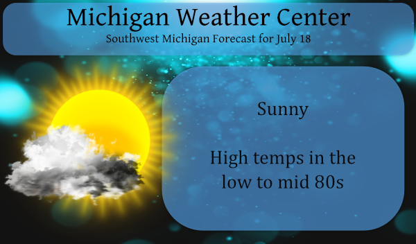
This week will be fairly quiet with warm temps and lots of sunshine in the forecast.
Forecast Discussion:
-- Warm through Tuesday with hazy skies --

With the departure of the upper-level trough to our south and
east, we will be under weak ridging and split flow with the
surface high centered just to our west. Now that we are in the
climatologically warmest part of summer, these high temperatures
in the mid 80s the next few days can be considered near normal.
Dew points in the mid 50s to lower 60s is also pretty tolerable
for most people`s comfort (the heat index won`t be much higher
than the temperature in this case). A few diurnal cumulus may
bubble up but otherwise it will be quite sunny.

The HRRR-Smoke is showing a relatively dense plume of forest fire
smoke advecting in from the north during the day and remaining
overhead through Monday. This microscopic particulate matter
should be suspended mostly between 2 and 4 km above the surface,
though the model shows some mixing down to the surface Monday
afternoon, especially in mid and eastern Lower Michigan. If that
were to verify, it could result in visibility at the surface
reduced below 10 miles. Regardless, expect hazy white skies and
discolored sunrises/sunsets. NWS Gaylord tweeted photos of the sun
setting through smoke Saturday evening.

-- A few thunderstorm chances this week --

A digging upper-level trough and associated jet streak exit
region will approach Michigan from the northwest on Tuesday, after
cresting the poleward side of the western CONUS heat dome
anticyclone. The surface cold front from the north may help
initiate scattered thunderstorm development during the afternoon.
Storms are most probable east of US-131, likely moving south-
southeast down the US-127 vicinity and east of there, as the
diurnal confluence of surface winds will be maximized in this
area. GFS and ECMWF show surface-based CAPE at Lansing in the
ballpark of 500-1000 J/kg and 0-6 km shear about 30 knots, so
can`t rule out a locally strong to severe wind gust or large hail.

Low-level warm air advection from the west Wednesday night into
Thursday ahead of another digging trough over the northern Great
Lakes on Thursday may also promote thunderstorm development. ECMWF
ensemble members give a less clear signal on the the time frame
of concern with this, sometime between Thursday and Friday. There
may also be another shortwave passing through next weekend which
would give us another chance of storms.
Summer rain sure is fickle. Our farm is in southern Allegan county about 15 miles off Lake Mich. 11 inches in June. .45 so far July.
As MV stated we now at the high point of the summer season temperature wise. Starting on the 21st we will start the downward trend. When you stand back and look at our summer and winter season they are shorter than one is lead to believe. That is why it is better to use meteorological seasons rather than the so-called calendar season. Here at Grand Rapids the average daily mean is now at 73.0° (30 year average) or 74° (15 year average) By August 31st that is down to 68.7 (30 year average) or 69.0 (15 Year average) and if… Read more »
I generally consider May 21- September 21 the ‘summer’ season, as temperatures are typically always in the 70s-90s for highs (besides the occasional cool down). Even though temperatures “fall” starting on July 21, I still consider the next couple months to be just as warm but with a weaker sun angle.
Spent yesterday in Mt. Pleasant for my niece’s wedding. Picture perfect day for a wedding. Driving home, the smoke was noticeable. As the sun was approaching the horizon, the smoke filtered out all of the glare. It was a beautiful orange orb.