We have been blessed with mainly calm weather thus far this spring, compared to our neighbors to the south and southwest. Looking at videos and snapshots of the tornado damage I am once again amazed at the damage of the various tornadoes paths, especial one where a mobile home was completely removed from its pad while another just a few feet away appeared to be untouched.
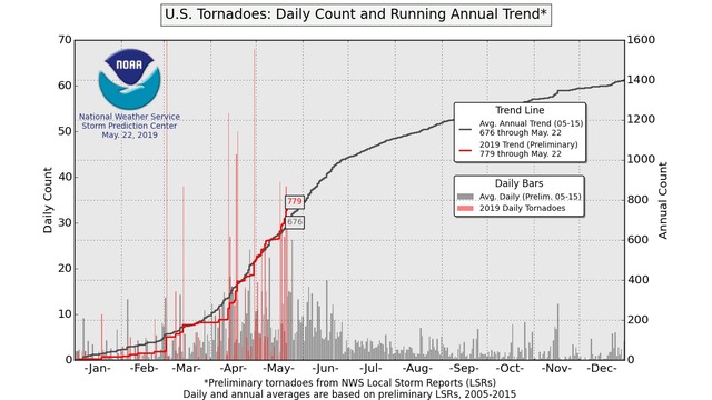
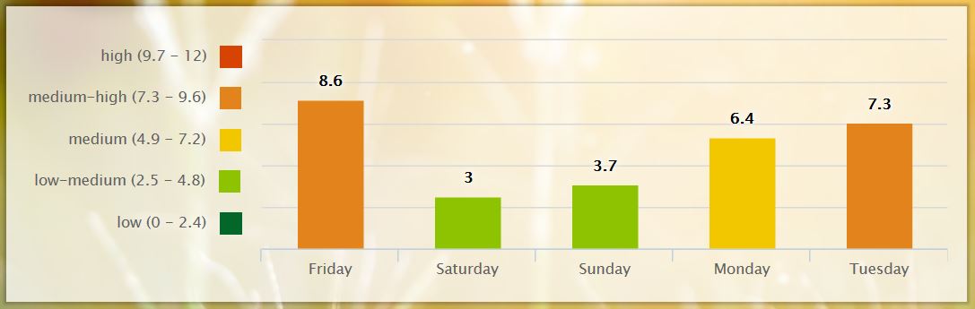
We have had over 200 tornadoes this week alone in the U.S.. The SPC graph above shows we have had above normal tornadoes this year with 779 reported compared to an ‘average’ of 676. Severe weather tracks are creeping northward from the deep south to the central plains – I can’t help but think we will continue with our active weather pattern and the severe weather outbreaks will move north into the northern plains and great lakes.
For 37 years, the most extensive tornado outbreak on record, in almost every category, was the 1974 Super Outbreak, which affected a large area of the central United States and extreme southern Ontario in Canada on April 3 and April 4, 1974. Not only did this outbreak feature 148 tornadoes in only 18 hours, but an unprecedented number of them were violent; 7 were of F5 intensity and 23 were F4. During the peak of this outbreak there were 16 tornadoes on the ground at the same time. More than 300 people, possibly as many as 330, were killed by tornadoes during this outbreak. However, this record was later broken during the 2011 Super Outbreak, which resulted in 360 tornadoes and 324 tornadic fatalities.
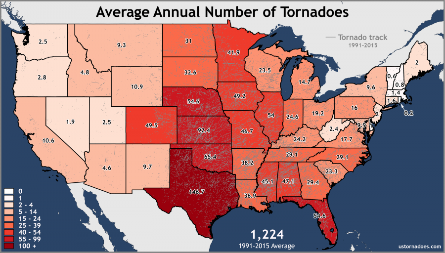
2018 is the first year since official records began in 1950 that no tornado in the US was rated violent class (EF4/EF5, or, previously, F4/F5). We are more than making up for this in 2019. Below is a map showing the average of tornados by state.
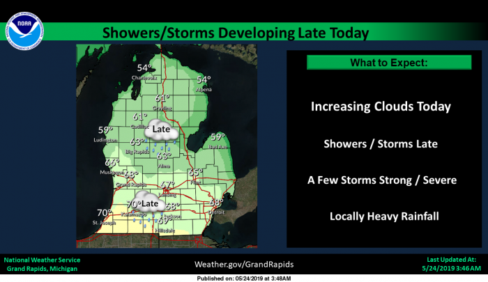
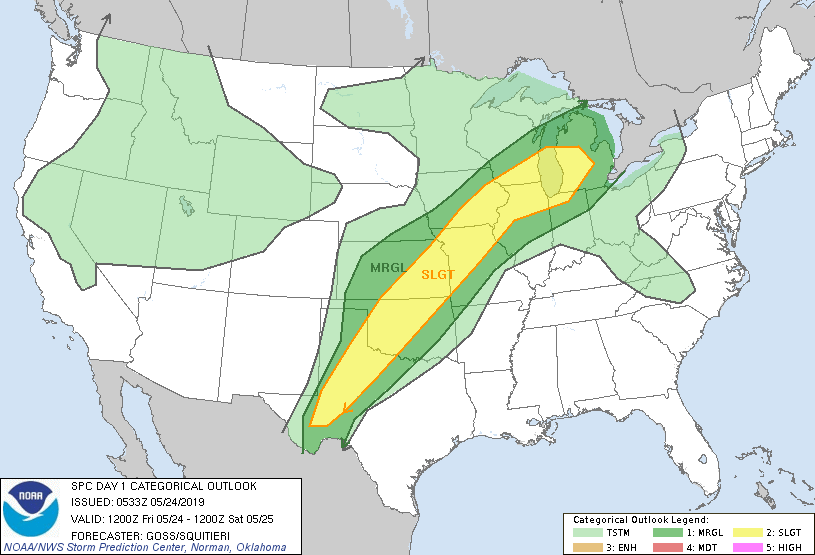
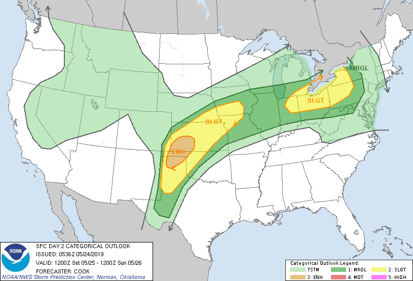
Below are the SPC outlooks for today and tomorrow – we are in the slight risk area for severe weather today for SW Michigan. We have a large area of rain and storms moving in from the west and south this morning.
[columns] [span6]
[/span6][span6]
[/span6][/columns]
Thunderstorms will develop late today and continue tonight. A slight chance of severe storms exists across much of southwest Lower Michigan. Large hail and strong winds are the primary threats. Thunderstorms will possible through the weekend, continuing Monday night through Wednesday night, so our active weather pattern continues.
An area of showers will cross central Lower Michigan this morning into early this afternoon with showers. An area of more significant showers and thunderstorms just ahead a warm front will bring widespread showers and thunderstorms tonight. Some storms may be strong with an isolated severe storm not out of the question early tonight west of Grand Rapids. Heavy rainfall is expect tonight.
Seven Day Forecast
Pollen Forecast
Seeing some lightning to the south.
Rain and temps in the 50s .. This pattern looks like it will hold well into June .. Furnace will be running into summer this season .. I have 58 at my house ..
Jeff we are going with fires to keep us warm don’t feel like paying a gas bill in June lol..INDY!!
I hear ya Indy .. We dont have that option though. 🙁
Yes this a below normal temp pattern and it keeps rocking! 5 months and counting! Incredible!
Well, I have not needed to use the irrigation system yet. This is the best my lawn has ever looked.
Seeing highs mid 60’s next week that’s cold for the last week of May if you ask me ..INDY!!
WOOD has 77, 77, 75, 80, 74. That’s warm!
Lol better hope it don’t rain like today temps struggling to reach 60* degrees! INDY!
Funny how some people on the blog can not even admit our 5 month below normal temp pattern is locked in! Facts really do matter! Who knew?
You mean 4 above average temp years in a row and counting? Hmmm
Your comment shows your total ignorance!
Light rain falling here at this time with a temperature of 54° The latest CFSv2 is indicating a brief warm up and then back to below to near average temperatures. As of today Grand Rapids mean for May is at 55.0 that is a departure of -2.4° the average daytime high so far is at 64.6 that is -3.6° below the average (mean) high that should be 68.2° the lows have been closer to average with then mean low now at 45.3 that is still -1.2 below the average mean high for this late in May of 46.5°
Slim
Keep the facts rocking! We have been in a below normal temp pattern for 5 straight months! Absolutely incredible!
7 out of 9 of the last days have been above average, and it looks the majority of the next 8 days will be warm too. Loving this weather!
4 more months to bow hunting season!! With the cool weather hanging around it will be here before we know it ..INDY!
False. It’s not even June yet. 4 or 5 months of great summer weather ahead!
More warm weather hype!
Lol must not be a hunter ..INDY!
Beautiful sunrise this morning – here a a screen shot from the South Haven web cam:
Beautiful!
👍