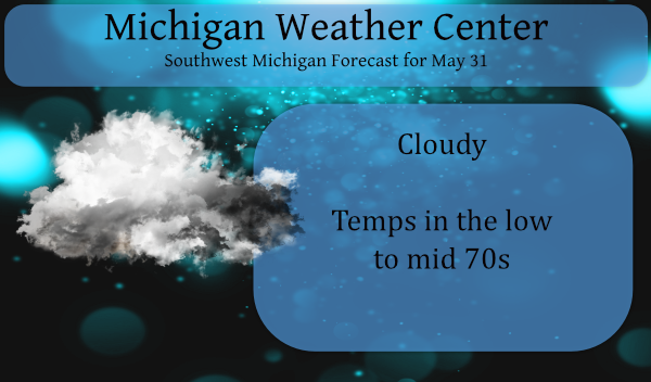
Our long weekend had been nice albeit a bit on the cool side especially in the mornings but today we begin to see a gradual warm-up until we reach the other end of temperature extremes. Rain will generally be north of I96 today with cloudy conditions most everywhere else.
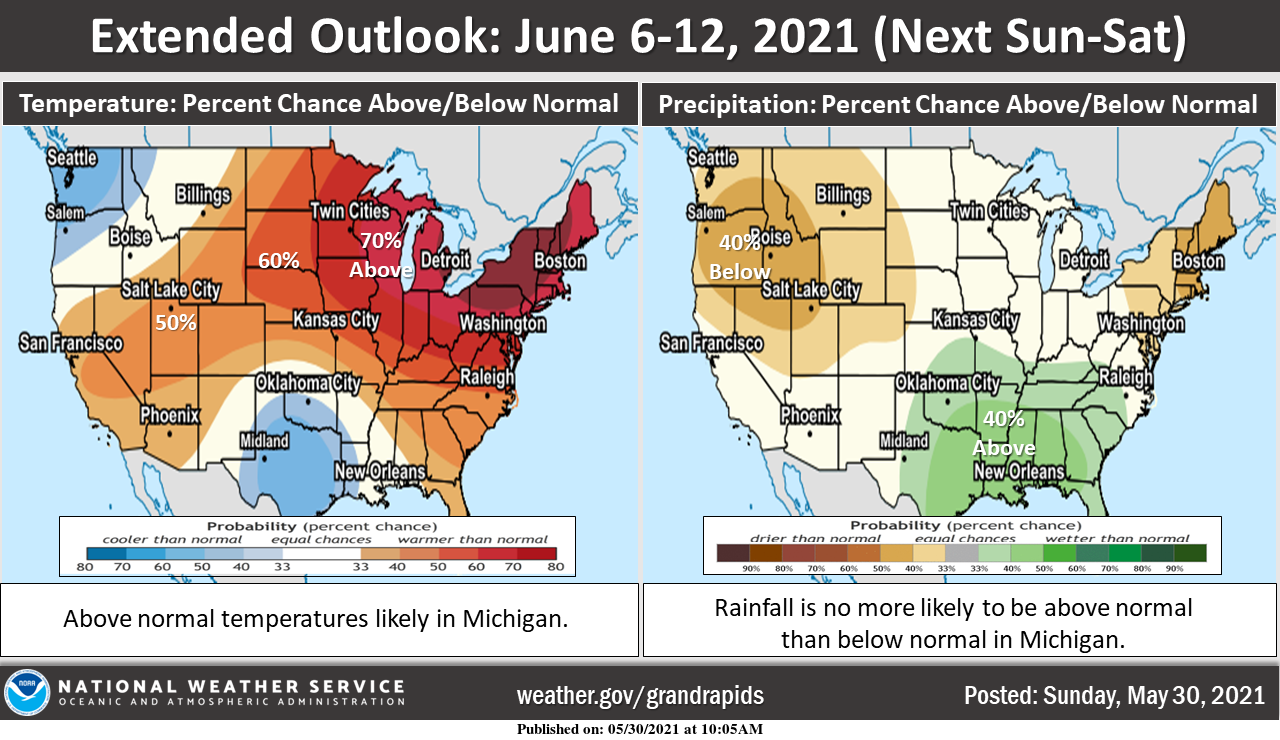
Temperatures look like they will warm up considerably by next weekend and stay warm through next week (June 6-12). We are likely looking at high temperatures reaching the 80s most days across West Michigan. Some days may be well into the 80s. We typically see at least a few chances for rain over the course of a week this time of year, and it looks like this will be the case, although it’s too far out to pin down the timing of any rain or thunderstorms yet.
We will close out the month of May with 1.32 inches of rain and 4.47 inches for the spring season which is well below normal for the Otsego/Plainwell area. Driving around Allegan and Kalamazoo counties I have seen the hay, corn and soybeans struggling due to lack of rain and the cold overnight temps. We add this to the below-normal snowfall season and we have issues with anything growing with the exception of weeds of course. I have had to dig a few post holes this year and have found the moisture level down to about 18 inches below the surface (this is in a sand dirt mix).
Forecast Discussion
- Dissipating thunderstorms from the NW this evening

The atmosphere in WI becomes rather unstable this afternoon and
evening. There also is a stronger mid level wave in northern MN
tracking east. Thus organized convection should develop in that
region. Those storms will try to track into northwest parts of the
CWA...around Ludington this evening. However the atmosphere is
shown to be stable or stabilizing across the CWA. This should
support a weakening trend to any storms the try to push in.
However there may be enough momentum for a few storms to make it
into northwest parts of the CWA. We will hold onto the low risk
for thunderstorms in that region for this evening.

- Risk for Thunderstorms later Thu

The mid level wave seen on water vapor imagery tracking into
southern AZ and NM is shown by the models to move into the OH
Valley Wed into Thu. This places the CWA on the northern side of
this system...which will be carrying abundant moisture with it.
Elevated instability arrives and some surface based instability
also develops Thursday. Thus a risk for thunderstorms is forecast
to occur then. The main focus for heavier rain and organized
storms stays south of the CWA. The highest qpf in the forecast
will be in the Upper Grand Basin...closer to the expected storm
track. We will need to monitor trends on this storm system as a
northward trend of the track could support some heavier rain
further north into the CWA.

- Near seasonable High temps into Thu then warmer than normal

Temps at 850 mb are shown to remain in the 8 to 10 deg C range
over the next couple of days. Assuming we can mix to the
level...we should end up with High temps near seasonable values.

Mid to upper level ridging moves in behind the departing storm
system for the end of the week before tracking east of the region
for the weekend. This supports deep warm air advection. Warming
temperatures are expected each day here in MI with perhaps a few
90s by Sunday. Isolated storms are possible each day for the
weekend but the main focus is shown to be off to the northwest.
Hear is Richie Furay …America America
https://youtu.be/KTve_3gm60c
The updated long range is now in from the CPC and it this plays out Mookie will be on here a lot after being absent this past week.
https://www.cpc.ncep.noaa.gov/products/predictions/30day/
Slim
Ha, one returns and 2 others disappear. Not looking forward to another heat wave this early already. Past couple days have been perfect with the low humidity. To bad it can’t stay like that all year.
I hope everyone has a enjoyable Memorial Day. After 3 nights in a row of lows in the 30’s the overnight low here was a milder 46. At this time it is cloudy and 55 here at my house. Officially Grand Rapids will end spring with 5.34″ of rain. The 30 year average for spring is 9.38″ There was a total of 0.3″ of snow fall that was well below the average of 9.6″ of spring snow fall. Grand Rapids ended last winter season with 41.6″ of snow fall and that is -31.5″ below the average of 77.6″ That was… Read more »
Thanks for the stats Slim. Half the rain and a tiny, tiny fraction of the snow this year. Could get really bad with the coming heat.
Ahhhhh nothing better being up north with cool crispy Fall like weather and the smell of camp fires all weekend longggg ohhh and the ice cold sprites baby what a fantastic weekend happy Memorial Day thank you hero’s…. Have a hoodiee of a day ….INDY