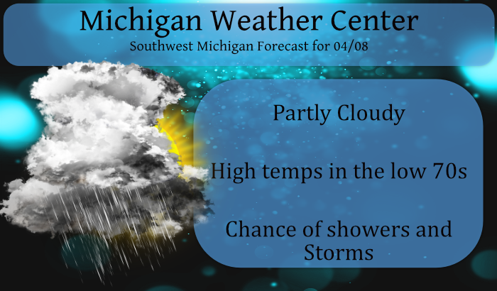
We have had the beginnings of another dry month with only a tenth of an inch of precip thus far. We have the promise of rain today mainly late this morning and throughout the afternoon. Our high temp yesterday was 79.9° and this morning at 5:30 we have a warm 64.9° which is well above our normal high temps for this time of year which would be in the mid-50s.
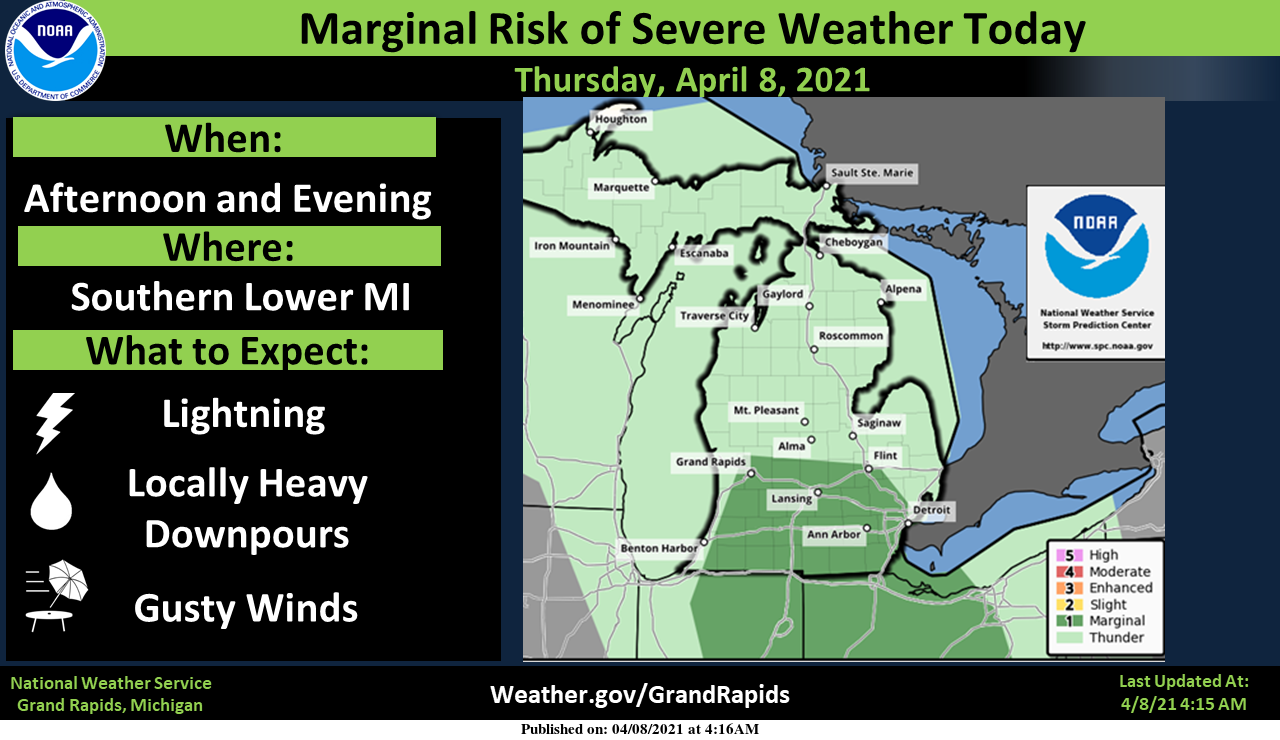
Bands of showers and thunderstorms will move into southern and central Lower Michigan this afternoon. Damaging winds are possible with the strongest storms. Locally heavy rain and lightning strikes can be expected as well.
Forecast Discussion
-- Showers and scattered thunderstorms today --

Regional radar shows a large swirl of precipitation rotating around
a low in Iowa. There have been a few showers/isold storms over
northern lower earlier this evening, but the CWA has been mainly
dry. That will change today as the upper support of the low moves
east and pushes showers and scattered storms north into Lower MI
ahead of the occluded front. These storms will be mostly non-severe.
Although there is a window from 21z-01z where a couple of storms may
become strong. This is when shear values will be maximized around 30
knots. Overall, instability isn`t tremendous, but MUCAPE values
around 500 j/kg late in the day may generate a few stronger wind
gusts.

Arcing bands of showers/storms seems like the most logical type of
propagation. Precipitable water values near 1.25 inches point toward
locally heavy rainfall in brief periods.

-- Wet through the weekend --

The upper low will be slow to move east and so we`re looking at
showers and storms to continue Friday. There may be a brief lull in
the showers Friday night, but another low is progd to move north
from the Gulf Saturday. The ECMWF is more bullish on this than the
GFS, but both models have this system and produce precipitation over
the CWA Saturday and Saturday night with the ECMWF continuing the
showers Sunday. The ECMWF deepens the low to 987mb which would point
toward some wind late in the weekend.

-- Cooler after Saturday --

The weekend low gets kicked out by another short wave moving across
the northern tier of states. Colder air gets wrapped into this
system and brought down over the Great Lakes. ECMWF ensembles shows
this cooler air beginning Sunday and continuing next week. Highs in
the lower 50s will be common next week.
Raining pretty hard here right now. My lawn is happy.
Mookie wondered how often there have been this many days of well above average highs this early in the season. In the month of April there will be this year April 4th to the 8th with highs of 71,69,78,80 and 74. April 3rd to the 7th 1929 with highs of 69,69,76,80 and 84. 2010 March 31 to April 7th with highs of 78,82,83,66,69,68,and 69. And of course the grand daddy of all spring heat waves was March of 2012.
Slim
With clouds and light rain now moving in it looks like most locations have reached their high for today. The reading of 74 at Grand Rapids ties the record high for the date last set in 1931. The reading of 74 at Muskegon is good for 2nd place. At Holland their 72 is good for 3rd place and at Lansing their high of 72 is good for a 5th place tie. At this time it is 72 here with some light rain falling. I will update if it gets warmer later in the day but at this time it dose… Read more »
1 week into April and it’s hard to believe it’s already been 6 weeks since we’ve had snow on the ground. High temp records continue to be broken around the areas, 75% of the days this year have been at or above average. I am not looking forward to Summer at all if this trend continues.
It’s too early to say how the summer will play out. If it stays dry then there will be a better chance of a warm to hot summer. It has been wet in Iowa so far this year so there is a chance that it could become humid but like I said it is too early to say. Weather patterns change around every 45 to at most 90 day. But that can be cold to warm or warm to cold or dry to wet or wet to dry. As we have been rather wet the past few years I would… Read more »
It is already officially 72 at GRR and 71 at Holland and 70 at Lansing 69 at Muskegon. The record high for today is 74 at Grand Rapids, 78 at Muskegon 80 at Lansing and 78 at Holland. It is already the 3rd warmest April 8th at GR and Muskegon. At this time it is cloudy and 75 here.
Slim
The good news is that even if things cool down, at least things have greened up and look like spring. And 50s are actually pretty comfortable with a jacket if it isn’t windy. Let’s just hope we are done with anything in the 30s and 40s.
71-69-78-80-75(?) You’d be pretty hard pressed to find very many 5-day periods in early April that are warmer than that! This has been extraordinary!
While there may be others the only other April with this kind of warmth that I can find at the start of April was 2010 when April first 5 days were 82,83,66,71,and 69. The next 2 days in 2010 were 68 and 69. April 2010 ended up with 4 days in the 80’s and 4 more days in the 70’s That year there were only 2 April days with highs in the 40’s and 4 days in the 50’s
Slim
This is for Indy.
I seen this today on Space weather.com. and of course I though of Indy
“Spring is the season for sprites, and Paul Smith just photographed a magnificent display over Kansas. “These were my first big sprites of the season,” says Smith, who took this picture on April 6th. Sprites are a weird form of lightning that leap up from powerful thunderstorms.”
Slim
Lol!! When they were talking about big Sprites I pictured this!
YES …Had to many sprites yesterday almost got stupid and turned on our air conditioning in our house lol…..Thanks Slim and Andy …..INDY
Yesterdays official high of 80 at Muskegon set a new record for the date at Grand Rapids, Kalamazoo and Lansing the high of 80 was the 2nd warmest for the date the. The high of 79 was also the 2nd warmest for the date there. The overnight low here was 60 and it looks like the overnight low at GRR was 57. At this time it is 62 with a few sprinkles here.
Slim
That high of 79 was the official high at Holland.
Slim
Things are greening up nicely and our trees are budding. I hope we get some decent rain. It’s still pretty dry out there.