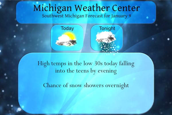
We had some freezing drizzle overnight with less than a tenth of an inch in most locations. We have 34° at 5:30 this morning. Temps will be falling throughout the day into the teens by late this afternoon. Yesterday’s high was 32.5° recovering from a low of 6.4° which was one of our coldest mornings thus far this winter. Another round of lake effect snow showers looks probable for tonight into Monday. Accumulations should be limited, but restrictions to visibility will be possible leading to hazardous travel.
The coldest air of the season will be passing through the state early this week with temps in the teens on Monday before making a recovery back into the 30s by Wednesday. The rest of the week should provide near normal temps with very little snow forecast until the next clipper system make an appearance next weekend.
We had 10 inches of snow last week in Otsego which brings us to 23 inches thus far for the season. Last year at this time we had only 8.7 inches, the year before that was 15 inches. Those seasons were mainly from synoptic events, not lake effect.
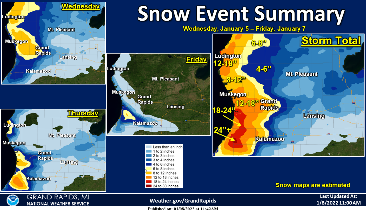
Here is a final summary of the snow event that occurred this past week. Snow maps are done for each day, and then a storm total map is included. The snow maps are estimated from official reports.
Forecast Discussion
- Falling Temperatures Behind Cold Front Today

A cold front will move into the area around sunrise this morning
squashing any lingering drizzle and resulting in temperatures
gradually falling throughout the day today. Temperatures will
start off in the 30s across the area and gradually drop into the
teens by this afternoon. While temperatures fall, winds will also
shift west- northwest behind the front and gust up to 30-35mph.
With tempeatures falling into the teens alongside gusty winds,
wind chills will be down to zero across the area this afternoon
and evening.

- Snow Showers Tonight into Monday

The coldest air of the season will sink further into place late
tonight and Monday with 850mb temps down to near or below -20C
across lower Michigan. Meanwhile another mid-level trough will slide
into the region with accompanying moisture. These combined factors
will support lake effect snow showers late tonight and Monday. The
main inhibitor on snowfall accumulations will be small snowflake
size as frigid temperatures push the DGZ nearly into the ground
with moisture also limited to below 5000ft. While accumulations
will be limited, visibilities may be impacted which will result in
some hazardous travel.

Snow showers may linger into early Tuesday, but as surface heights
build to our west with approaching high pressure, northwest flow
will be cut off and snow should come to an end by daybreak.

- Mild End of the Week and Possible Clipper to Note Next Weekend

With high pressure to our east Tuesday flow will turn southerly
and warm air advection will support quickly warming temperatures.
Temperatures will continuously warm throughout the day Tuesday and
into Wednesday with highs in the 30s for the second half of the
week.

The next item to note looks to be a potential clipper system next
weekend. Interestingly enough, there seems to be a rare day 5
consensus from the Canadian, GFS, and Euro on this system
impacting the area with measurable precip next weekend. Ensemble
agreement is still lacking quite a bit, however, so we still have
quite a ways to go in regards to ironing out details and gaining
confidence.
Hey INDY, what the heck happened to the Colts today and the end of the season?
Tell me about it pure crap ..Time for the coach and QB go …So disappointing….InDY
+1
Wow what a Winter weather wonderland driving north to Boyne mountain roads snowy covered and slippery with blowing snow conditions….InDY. …
Great winter weather!
It is really feeling colder outside especially when the wind blows.
The temperature is now down to 23 and windy here. With the sun shining thru thin clouds there are now a few flurries even with the sunshine.
Slim
Nice snow event map! I love that GR was in the 12 to 18 range! What a monster storm and great wether event! Lets see a bunch of these this winter! Nothing better than winter in West MI! Incredible!
The overnight temperature rose to 34 here. And there was some drizzle as well. Before the temperatures went above 32 there was some freezing drizzle. The current temperature here is 32 with cloudy skies. There is now 10.0″ of snow on the ground here at my house. For the month of January GR is now at 19.0″ of snow fall and for the season so far GR is at 38.8″ At Muskegon their January snow fall is at 15.9 and for the season it is now at 25.7″ To the east at Lansing there now have 6.4″ for January and… Read more »