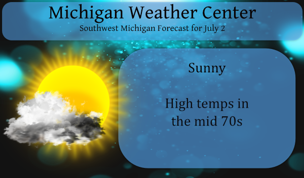
We have a great day in store for SW Michigan, in fact, much of the state will enjoy sunny skies, low humidity and comfortable temps. We have the whole the Fourth of July weekend with the expectation of sunny skies though the temps will progress higher each day.
We enjoyed comfortable sleeping temps with an overnight low of 55° last night. After a high in the mid-70s today we should see temps drop to the low 50s overnight. Better yet there is little expectation of rain in the forecast.
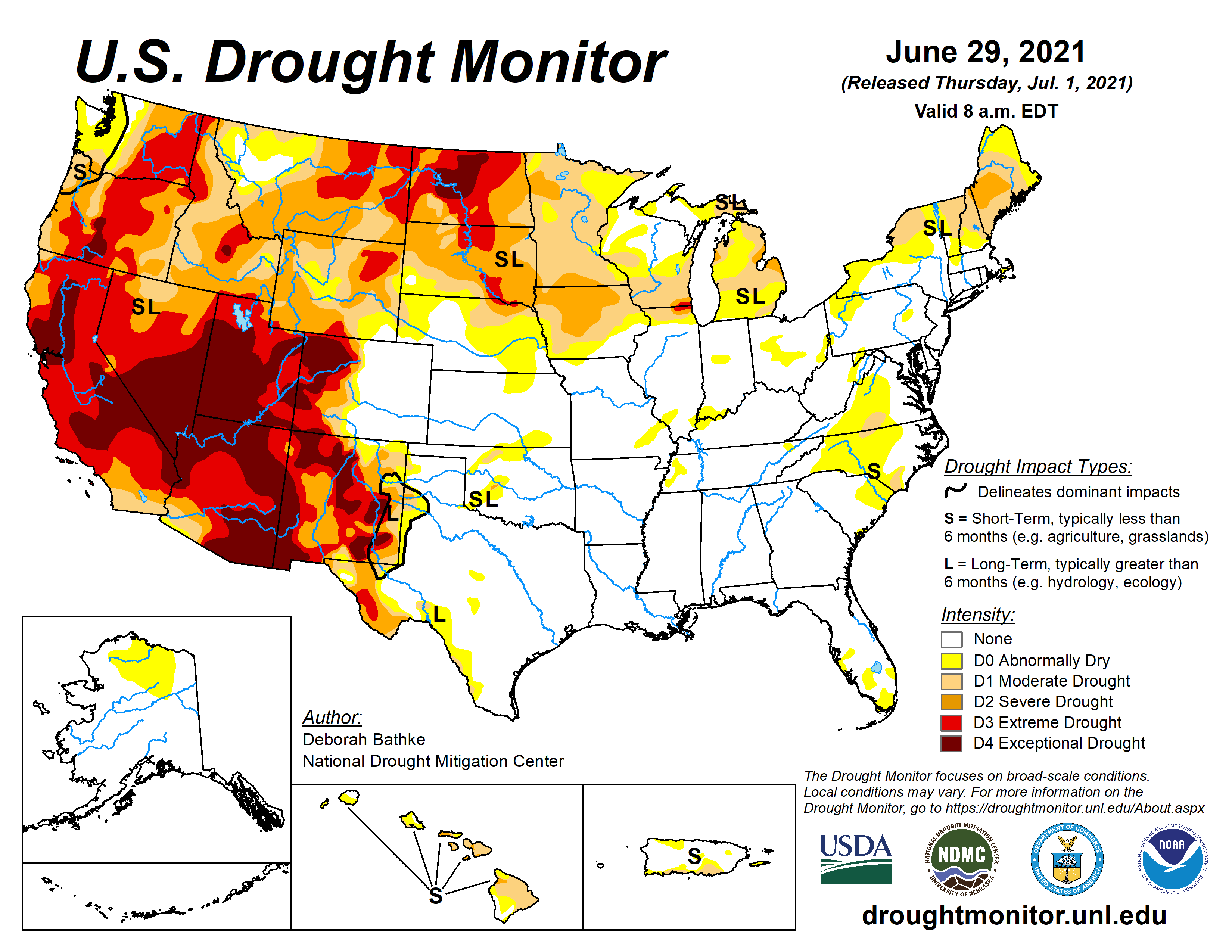 Even with all the rain we had the second half of June the CPC still has us in drought conditions though there was an improvement in south Michigan we still are below normal in the precip dept for the year.
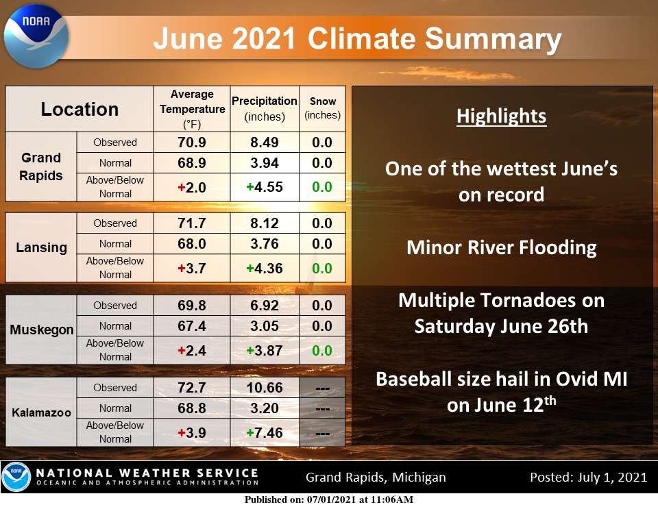
June was warmer than normal and wetter than normal month. In fact, Kalamazoo had the wettest June on record! Grand Rapids precipitation total was the 2nd wettest ever for June. Muskegon had the 4th wettest June on record. Lansing had the 6th wettest June. A total of 5 confirmed tornadoes touched down in West Michigan on June 26th. Multiple days had severe weather through the course of the month including baseball-sized hail on June 12th in Ovid, MI.
Forecast Discussion
-- Comfortable today, slight chance shower north tonight --

High temperatures in the mid-70s, dew points around 50, a fair
amount of sunshine, and a light breeze. Today should be
spectacular. We find ourselves on the back side of an upper-level
trough and surface low, in a meridional flow pattern, with north
winds extending from the surface up to the jet stream. The coldest
850 mb air in the short term is over us this morning, about 8
Celsius.

There`s still a highly anomalous 3-sigma ridge over central
Canada, the one responsible for the record-breaking British
Columbia, Washington, and Oregon heat wave. This ridge is in the
process of deamplifying as moves east. An extraordinary warm plume
of 25 Celsius air at 850 mb advected over northern Manitoba and
southern Nunavut on Thursday will move east into western Ontario
today, air in that layer being just a few degrees cooler than
yesterday. This eastward-advancing warm front with mid-level warm
air advection from the northwest may touch of elevated showers
that move south into Northern Lower Michigan after dark tonight.
They will have a tendency to weaken as they move into Central
Lower Michigan, but we`ll add a slight chance of rain there
tonight.

The brilliant blue sky we had yesterday may look a little dull
today and more so on Saturday. The RAP and HRRR smoke models show
plumes of wildfire smoke, originating from multiple fires between
western Ontario, northern Sask/Alberta, and British Columbia,
moving over the western Great Lakes, fairly light concentrations
today then more moderate on Saturday. The smoke overhead will be
mainly between 700 and 400 mb, or between 3 and 7 km above the
surface, so our air quality is not much of a concern from this.

A result of one of the wettest Junes on record for a portion of
the area, minor flooding along the rivers at Comstock Park and
Maple Rapids are past crest and river levels will continue to drop
through the weekend.

-- Warm holiday weekend with little precip chances --

Air coming to us from Canada isn`t always cold. As the Canadian
ridge deamplifies propagates east-southeast on Saturday, warmer
air will arrive from western Ontario amid north-northwest 850 mb
flow. This air in the upper teens Celsius will mix down during the
day, giving us high temperatures in the 80s F. It looks even
warmer on Sunday and highs could even approach 90. Dew points in
the mid 60s over the weekend will feel a little humid but not as
bad as the the 70s dewpoints in late June. Models are showing
surface-based CAPE during the daytime over the weekend, but
boundary layer parcels will most likely be capped without much
upper-level dynamic support.

-- Some precip chances middle of next week --

Ensembles are pretty tightly clustered on the temperature
forecast through Monday, and start to diverge on Tuesday and
beyond. The North American pattern becomes more quasi-zonal early
to mid next week, with a tendency for another hot anticyclone re-
establishing in the southwest CONUS, and some downstream troughing
across Ontario into the Great Lakes. Ensembles are not in
complete agreement of when it will rain, though chances look to
increase between Monday and Wednesday, with perhaps additional
chances later in the week.
July is looking fantastic! Get ready for below normal temps this month! I love it!
Low of 53* this morning in my area felt greattt with no big heat in sight and now into July this summer has been a pice of firework sofar not hot at all let’s keep it going to Augusta ……. Happy 4th of July weekend MV’s best light a fire cracker blow off a m-80 and drink some sprites tonight party on INDY
Interesting. Hot air dropping South out of Canada. Don’t see that very often.
No you don’t I remember it did in 1988 it was odd to have temperatures in the upper 90’s with a NW wind
Slim
June 2021 was the wettest on record at Kalamazoo, the 2nd wettest on record at Grand Rapids (the wettest was way back in 1892) the 4 wettest at Muskegon, the 6 wettest at Lansing and the 10 wettest at Holland. The official over night low at Grand Rapids was 56 and here at my house I got down to 55. At this time it is clear and 67 here at my house.
Slim