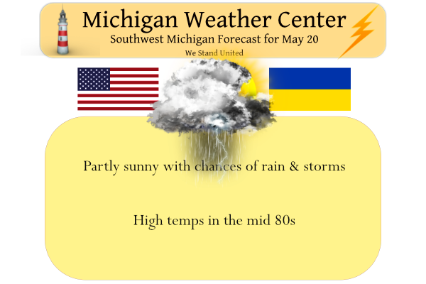
We have 64° at 4:30 this morning. There was a trace of rain from a few sprinkles passing through Otsego yesterday with a high of 77.5° and a low of 51°. Today we will see more summerlike conditions with partly sunny skies and high temps well into the 80s. It will also be breezy, with southerly winds 10 to 15 mph increasing to 16 to 21 mph in the afternoon. Winds could gust as high as 32 mph. We have chances of rain and storms through Sunday morning, chances increase tonight through tomorrow.
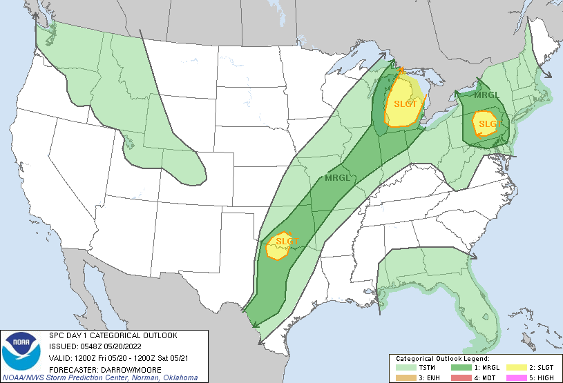
Isolated severe thunderstorms are possible across lower Michigan, northern Middle Atlantic, and a small part of the southern Plains.
SPC morning summary
Seasonally strong belt of southwesterly flow aloft will extend
   across the central Plains into the upper Great Lakes region as the
   primary upper trough holds farther west across the High Plains into
   the central Rockies. This flow regime will allow for a slow eastward
   progression of the surface front, likely extending from the eastern
   UP of MI into northern IL by early afternoon. In the absence of
   meaningful height falls, boundary-layer heating will prove
   instrumental in convective development later today. Latest model
   guidance suggests modest surface heating will be noted across lower
   MI ahead of the front. Forecast soundings suggest CINH will weaken
   across the eastern UP of MI into northeast WI by early afternoon,
   and scattered convection is expected to develop across this region
   first. Wind profiles favor supercells and this activity should
   spread/develop east-northeast ahead of the cold front across
   northern lower MI. Latest HREF members support this scenario and
   there appears to be some tornado threat with these supercells given
   the shear/buoyancy. Otherwise, hail and wind can be expected with
   this convection.
Forecast Discussion
...Best chance of storms is north today...

Not too much has changed since yesterday with the anticipated
evolution of the slow moving cold front and associated convection. A
slight risk of severe storms remains in place for much of Lower
Michigan. However, a capped environment south of I-96 suggests that
the majority of storms that develop will be over the northern half
of the cwa and northern Lower.

Low pressure in western Wisconsin will move northeast across Lake
Superior today and a trailing cold front will move slowly east, such
that by 21Z or so the front will be near the shoreline north of
Muskegon. Convergence near the front isn`t all that great as it`s
parallel to the nearly unidirectional flow. However, conditional
instability will be substantial ahead of the front. Forecast
soundings on the hrrr and namnest point toward MLCAPE in the 2-3k
j/kg range with a minimal cap. Bulk shear values in the 40-50kt
range point toward significant organizational potential with wind
and hail the main threat.

Areas south of a Holland to Alma line will see a strong cap in place
and should be basically dry through the afternoon.

...Tonight through Saturday night...

The front is progd to move through the cwa by midnight and then
stall near Toledo. This will place the cwa north of the front. We`re
going to see a couple of low pressure waves move northeast along the
front through Saturday night and each one will enhance chances for
showers and storms. However, the convection should be mainly
elevated and thus the main threat would be hail.

Saturday afternoon through Saturday evening looks like the most
likely time for showers/storms. MUCAPE increase to 500-1k j/kg
during this time and so a severe storm isn`t out of the question; a
marginal risk is indicated south of a Holland to Alma line.

The precipitation will move out of the cwa Sunday and we`ll see
clearing from the west during the afternoon.

...Cooler early next week...

After highs in the mid 80s today, temperatures will cool to below
normal values beginning Saturday with highs in the mid to upper 60s.
Highs in the upper 50s to mid 60s are expected Sunday and 60s Monday
and Tuesday.

Both the ECMWF and GFS show a low moving over the state Wednesday.
They are in unusual agreement with the location and timing and show
quite a bit of rain with this system.
Top headline on cnn.com is “Michigan tornado causes catastrophic damage”. They say at least 40 injured.
At least one fatality, unfortunately.
I was inside the tornado in Gaylord. I went storm chasing and was off the main exit just off I-75. I’m thankful to god to be alive. My car was hit with debris and came close to totally flipping the car. I got insane video. It touched down very rapidly and intensified coming into town. I was ducked down in my vehicle and thankfully not a scratch on me. The damage is horrible. I’ll update later.
Holy cow! I’m glad you’re safe. Don’t ask me how, but see if you can get your vid posted here.
Somehow my car does not have a scratch on it. I keep a small angel in my center console and a Bible behind the seat. Think god was taking care of me in that moment. I’m still in shock
https://www.youtube.com/watch?v=sjEuj2tjBdI
Wow crazy! Glad you are okay!! And that is some stunning video
Crazy and my idea of storm chasing is get as far away as possible! Some storm chasers have lost their lives trying to see a tornado! No thank you!
Nice vid, Kyle. I noticed Charles Russell commented. There’s a name I haven’t heard in quite some time.
Yes Charles used to comment on Bills Blog about a decade ago
Glad you are safe! You had your Guardian Angel working overtime today.
Wow! That was just crazy! Was that a person running outside in front of your car? Just nuts!
Confirmed tornado in Otsego county, per NWS Gaylord.
Meanwhile, 88 here and 81 in GR. The air is soupy and I am looking forward to the cold front.
That tornado hit Gaylord. Some pics:
https://www.9and10news.com/2022/05/20/gallery-tornado-through-northern-michigan/pic/1420807/
MD for up north:
https://www.spc.noaa.gov/products/md/md0840.html
There is now a watch for northern lower and several warnings as well. Latest radar shows some storm there but not really way out of line at this time.
Slim
They’re still talking about the possibilty for big hail. From that watch:
* Primary threats include…
Scattered large hail and isolated very large hail events to 2
inches in diameter possible
Scattered damaging wind gusts to 70 mph possible
A tornado or two possible
With some past talk of how GRR has been cooler than some other areas today seems to be a big exception. As Holland, Grand Rapids and Lansing with 85 are the warmest locations in southern lower Michigan with a 87 with down slopping winds at Alpena being the warmest.
Slim
Wanna to hear something crazy? Freeze Warnings from North Dakota to Colorado. Winter Storm Warnings in Colorado up to southern Wyoming. …WINTER STORM WARNING REMAINS IN EFFECT FROM 4 PM THIS AFTERNOON TO NOON MDT SATURDAY… WHAT…Heavy snow expected. Total snow accumulations between 3 and 10 inches, heaviest amounts near the foothills and southern portions of the Denver metro area. Lighter amounts toward Fort Collins. WHERE…Fort Collins, Boulder and the western suburbs of Denver, and Denver. WHEN…From 4 PM this afternoon to Noon MDT Saturday. IMPACTS…Heavy snow will accumulate on tree branches and powerlines, possibly causing them to break and… Read more »
Sounds awesome! Bring it!
Next week lows in the 40’s and highs barley making 60! Crazy late May cold! The cool pattern keeps rocking! Wow, just wow!
Enhance risk coming for GR to Lansing north is my guest with the next spc out look around 1230pm stay tuned..InDY
Good call on the time. The slight risk area moved even farther north.
https://www.spc.noaa.gov/products/outlook/day1otlk.html
And the current radar would support that northward trend.
Slim
Area Forecast Discussion National Weather Service Grand Rapids MI 1107 AM EDT Fri May 20 2022 LATEST UPDATE… Update .UPDATE… Issued at 1022 AM EDT Fri May 20 2022 – Severe storms remain possible after 3 pm through 10 PM. The cold front continues to move through Eastern MN and through WI late this morning. The front will reach Michigan around 3 PM with convection firing along and out ahead of it. An inversion remains in place and temperatures will need to be into the 90s for surface instability to breach that inversion. That inversion will be the limiting factor… Read more »
Im thinking a watch of some sort coming this afternoon possibly Tornadoe watch there could be damage from these storms everyone in lower Michigan have a safe plan now …InDY
After this big stretch of heat, it looks like some more is brewing!
My yard is looking super green and lush. My hostas are close to blooming. Last year, this didn’t happen until July!
The blooming time looks to depend on the variety
When and for how long hostas bloom depends mostly on the variety. “Blue Wedgewood” and “Blue Umbrella” grow in U.S. Department of Agriculture plant hardiness zones 3 through 8, and bloom for a few weeks in June. The August lily (Hosta plantaginea) grows in USDA zones 3 to 9 and blooms in late summer to fall.
https://homeguides.sfgate.com/long-hostas-bloom-71220.html
Slim
Update from SPC. Sounds as if any supercell that manage to for could produce 2”+ hail. Sig-Hail probabilities have been introduced from Gratiot, Montcalm and points north and east.
“The most favorable buoyancy/shear parameter space for severe thunderstorms — including a few supercells with a tornado threat, damaging winds and large to significant hail — will be across
central/northern Lower MI.”
That would be just to the northeast of the Grand Rapids area.
Slim
Of course if modeling is off by 50 miles then GRR could still get some action. But yes looks like highest changes are to the north of GR. 2 inch hail is pretty crazy!
No kidding. That size hail would be very damaging.
Hopefully the hail forecast is overdone… I love storms but anything that causes substantial damage is something I never want to see
The official H/L yesterday at Grand Rapids was 75/51, officially 0.01″ of rain was reported. The overnight low in MBY was 61 and the official overnight low at GRR was 62. At the current time it is sunny and 69 here at my house. The forecasted high today is 85. That would a top ten warmest for this date the record high of 92 set in 1977 looks very safe it was 90 on this date in 2012 and just last year the high reached 88. It looks like the best chance for storms has now moved to the north… Read more »
Im thinking enhanced risk coming for GR to the north on the next update plus we may have flooding rainns to lots happening today ..INDY
Indy this it the latest from the storm prediction center issued 756 CDT
..Lower MI…
Scattered thunderstorms are expected to develop this afternoon —
perhaps in multiple episodes – ahead of the surface cold front, from
west of central/northern Lake Michigan across central/northern Lower
MI. The most favorable buoyancy/shear parameter space for severe
thunderstorms — including a few supercells with a tornado threat,
damaging winds and large to significant hail — will be across
central/northern Lower MI.
Slim
The cap has broke the severe weather chances are rising the possibility of Tornadoes is a good bet this afternoon in lower Michigan someone maybe getting a F3 Tornadoe somethings to keep in mind heading into the afternoon very serious weather situation unfolding right now ..Stay safe everyone INDY
Today will be our 10th warm day out of the past 12 days!
After a brief one day of very warm summer like temperatures it looks like maybe a week of cool temperatures. But after a week or so of cool temperature there are hints that there could be a warm up at the end of May and the start of June.
Slim
Yesterday GR hit 75 degrees. Average high was only 71. Today we will hit the mid 80’s. I’m loving it! Especially just after our blowtorch last week.
It should be noted that the high of 54 on May 18th was the 5th coldest maximum of any May 18th at Grand Rapids. It was the 7th coldest maximum at Lansing and Holland. The forecasted highs next week would be 5 to 10° below average.
Slim
Why should that be noted? LOL
Keep the facts rolling Slim! I love it!
The severe weather parameters in place across Central and Northern Lower Michigan are definitely something to not take lightly. It ultimately remains to be seen how everything materializes over the coming hours but there is definite signs for maybe some supercells in the state today. I’ve looked at the GFS, NAM, HRRR and all show decent parameters and favorable sounding for supercells and maybe a couple tornadoes. The issue for West MI is the capping that is in place, especially from GR to the south. Capping doesn’t appear to be as strong to the north, which appears to be where… Read more »
Our local mets this morning said they’re not too confident as to chances of precip in this area tonight and tomorrow. Hit and miss…..but more miss than hit. They did say that anything that pops up/evolves can have the potential of becoming severe.
I’m hoping for more miss than hit. The East Lansing Art Fair is this weekend. 🙂
Yeah we have our community wide garage sales the next couple days so people are looking for good weather here as well.
I went to the East Lansing Art Fair a few years ago… it is actually one of the better ones I’ve been to
Get ready for the major cool down! Below normal temps will rule this weekend and next week! Wow just wow! The below temp pattern still dominates! Who would have thought?