Heating and Cooling Degree Days
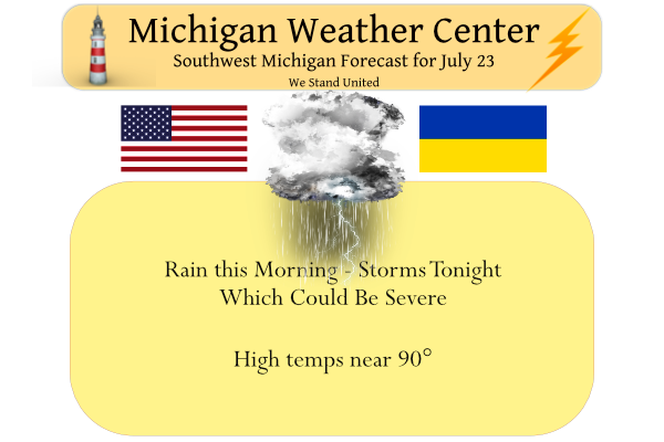
Update: SW Michigan has been updated and added to the Enhanced Severe Weather outlook.
Degree days are based on the assumption that when the outside temperature is 65°F, we don’t need heating or cooling to be comfortable. Degree days are the difference between the daily temperature mean, (high temperature plus low temperature divided by two) and 65°F. If the temperature mean is above 65°F, we subtract 65 from the mean and the result is Cooling Degree Days. If the temperature mean is below 65°F, we subtract the mean from 65 and the result is Heating Degree Days.
Example 1: The high temperature for a particular day was 90°F and the low temperature was 66°F. The temperature mean for that day was:
( 90°F + 66°F ) / 2 = 78°F
Because the result is above 65°F:
78°F – 65°F = 13 Cooling Degree Days
Example 2: The high temperature for a particular day was 33°F and the low temperature was 25°F. The temperature mean for that day was:
( 33°F + 25°F ) / 2 = 29°F
Because the result is below 65°F:
65°F – 29°F = 36 Heating Degree Days.
The calculations shown in the two examples above are performed for each day of the year and the daily degree days are accumulated so that we can compare months and seasons.
HOW TO USE DEGREE DAYS:The most common use of degree days is for tracking energy use. Without degree days, comparing the energy used over two periods would be analogous to calculating the miles per gallon rating for your car without knowing how far you had driven. If you wanted to know if the attic insulation you added over the summer was saving energy, you would use your energy bills to determine how much “fuel” was used before and after the retrofit. Then, using the degree days, you could determine “how far you went” during those periods. Instead of calculating miles per gallon, you would determine kWh’s per degree day or therms of natural gas per degree day.
OTHER FACTORS : When comparing energy use, you should also consider other energy uses that are not impacted by weather such as lights, appliances, etc. You can estimate the energy used for these purposes by examining the energy used during temperate months such as May and October when little heating or cooling energy is used. The energy used during these periods reflect your base monthly consumption. Subtracting the base use from the total consumption during a winter month will yield an estimate of the energy used just for heating. It is also important to consider the usage period reflected in your energy bill. Your meter is probably not read on the first day of each month and therefore will not be for the same time period as the degree day totals. You can allow for this by comparing over a longer period, such as an entire heating season or several months.
Here in Michigan, we have more heating degree days than cooling degree days. Here in Grand Rapids the average number of cooling degree days is around 700. The most cooling degree days is 1200 in 1921 the least was just 316 in 1999. The average number of heating degree days at Grand Rapids is 6690 the most was 7712 in 1904 and the least was 5253 in 2012. For a comparison Orlando FL the average number of Heating Degree Days is 562 the most was 1080 in 1958 and the least was just 183 in 1949. For Cooling Degree Days the average at Orlando is 3462 the most was 4267 in 2015 and the least was 2884 in 1910. As you can see we have more Heating Degreed Days per year than Cooling Degree Days.
So far at Grand Rapids this July has had 189 Cooling Degree Days and for the year so far there have been 439. As for Heating Degree Days so far this year there have been 4243.
Slim
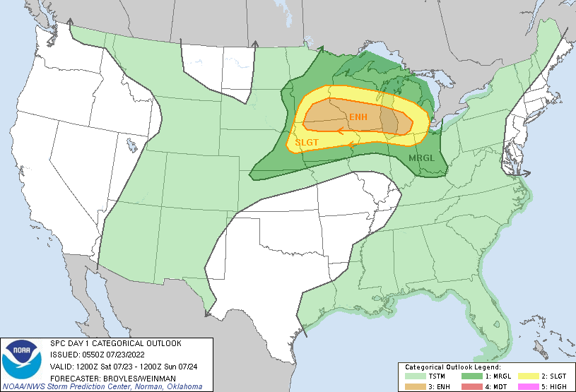
An upper-level trough, currently evident in water vapor imagery over
   the northern Rockies, will move east-southeastward across the
   northern Plains today. At the surface, a low and an associated cold
   front will move southeastward from central South Dakota into the mid
   Missouri Valley. Ahead of the front, a moist airmass will be in
   place from the mid Missouri Valley eastward into the southern Great
   Lakes, with surface dewpoints in the upper 60s to mid 70s F. As the
   trough approaches the northern Plains this morning, scattered
   convective initiation should take place across the central Dakotas.
   Convective coverage is expected to expand as a cluster organizes
   into a line around midday. This line is forecast to move
   east-southeastward across southern Minnesota and northern Iowa by
   early afternoon, and then eastward across southern and central
   Wisconsin during the mid to late afternoon.

   RAP and NAM forecast soundings near the strongest instability in
   southern Wisconsin at 21Z have MLCAPE in the 4000 to 5000 J/kg
   range, with 0-6 km shear of 30 to 35 knots. Directional shear is
   evident at low levels with strong speed shear present at mid levels.
   The RAP has lapse rates near 8.0 C/km throughout the forecast
   sounding, suggesting that any line that can become organized will
   likely produce wind damage. The best potential for damaging winds,
   including gusts above 70 knots, is forecast from southeast Minnesota
   and northwest Iowa eastward across southern Wisconsin, near the axis
   of strongest instability. Supercells that develop within the linear
   MCS could also produce large hail, with hailstones greater than 2
   inches in diameter possible. A few tornadoes may also occur with bow
   echoes or rotating cells that form within the line.

   The linear MCS is forecast to continue to move east-southeastward
   into southern Lower Michigan by early evening. Although model
   forecasts have a greater spread concerning instability in southern
   Lower Michigan, it seems likely that moderate instability will be in
   place. This should enable the linear MCS to remain severe as it
   crosses southern Lower Michigan, where wind damage will be likely.
Wow we just got nailed at my house. No power. Very strong winds. Id guess 60mph
I hope you get it back. Not a good night for no A/C. Still 79 here and lows are supposed to remain in the 70s.
Thunder is picking up again.
Typical fail for Ada. Distant flashes, and a handful of distant thunder. The only upside is the rain.
We are getting heavy rain here and lots of lightning. The wind is whipping the rain in every direction.
Strongest winds are from Ravenna down to Allendale at this point. Outages and tree damage in Muskegon County.
With the storm coming from the North West we have a great view from atop our hill of all the lightning, and there is a lot! See if this rain falls apart like all the other showers that come through.
RadarScope showing some winds near 70 over the lake. Granted that’s a little above the surface but 60-65mph seems possible
NWS just updated the text to show 70mph winds in the warning text.
gee, there is another person who uses Radarscope besides myself – must be a tracker…
RadarScope is the best IMO. Best way to gauge storm intensity.
I agree – I have been using it for somewhere around three years.
* Severe Thunderstorm Warning for…
Ottawa County in southwestern Michigan…
Muskegon County in west central Michigan…
* Until 1015 PM EDT.
* At 843 PM EDT, severe thunderstorms were located along a line
extending from 22 miles west of Silver Lake SP to 30 miles
southwest of Montague to 16 miles east of Cudahy, moving southeast
at 40 mph.
SEVERE THUNDERSTORM WATCH OUTLINE UPDATE FOR WS 495 NWS STORM PREDICTION CENTER NORMAN OK 835 PM EDT SAT JUL 23 2022 SEVERE THUNDERSTORM WATCH 495 IS IN EFFECT UNTIL 1200 AM EDT FOR THE FOLLOWING LOCATIONS MIC005-015-025-045-067-077-081-107-117-121-123-127-139-159- 240400- /O.NEW.KWNS.SV.A.0495.220724T0035Z-220724T0400Z/ MI . MICHIGAN COUNTIES INCLUDED ARE ALLEGAN BARRY CALHOUN EATON IONIA KALAMAZOO KENT MECOSTA MONTCALM MUSKEGON NEWAYGO OCEANA OTTAWA VAN BUREN
Bring on the rain! It was another nice summer day!
15th 90-degree day of the season.
That line in WI looks impressive. Let’s see how well it stays together.
…Severe weather risk this evening into tonight… Instability continues to build over the CWA this afternoon although it has been delayed a few hours by the earlier complex. Looking upstream in WI surface based CAPE values have risen to over 4000 J/kg for southern parts of the state. A coupled low level/upper level jet has generated vigorous convection near Minneapolis…which is headed our way. The instability if forecast continue to increase over the CWA this evening ahead of this approaching complex. Forecast effective deep layer shear is also progged to top 60 knots on the backside of this complex as… Read more »
Yet another dry night…
“linear MCS to remain severe as it crosses southern Lower Michigan, where wind damage will be likely”
Yuck. In other words, it’s likely folks in my neighborhood will be without power for the next day or two. Gonna fire up the chain saw and generator just to be prepared.
We will leaving for Detroit in a little while. At this time with a 6 PM start time it looks like the rain will hold off until after the game. I hope the Tigers don’t get beat up too bad (well I hope they get some hits at least LOL) At this time it is not too bad with temperatures here in GR in the low 80’s and the last reported DP was 61 (I have a DP here of 67 with a temperature of 84) The current reading at Detroit is 81 with a DP of 65.
Slim
Thanks Slim. I know it’s been explained before but it still was a little confusing, that helps make it more understandable. One question I have, on the daily climatological report why do the degree days heating only go back to July 1 but the degree days cooling go back to January 1? Makes it hard to compare for the year.
That is a good question Barry, unfortunately I don’t have a good answer. Most year the cooling season starts around here in May (there have been some years with a April and very few with a March) start. I know the NWS start the snow fall amount on July 1st but not sure why they do that for the Cooling Degree Days and not for the Heating Degree Days.
Slim
So far meteorological summer at Grand Rapids and Holland has been just a little warmer than average. At Muskegon June was near average and so far July has been warmer then average. At Lansing June and July have been warmer than average. As for the number of 90 degree days so far Grand Rapids is at 7 Holland is at 6 Muskegon is at 4 Kalamazoo is at 11 and at Lansing they are at 14 so far. Thus as has been the case for some time Lansing for some reason is running warmer than most other locations.
Slim
More sunshine and no cooling from the Lake. 😁
Yesterdays official H/L at Grand Rapids was 90/68 There was no rain fall as of midnight, there was 95% of sunshine. I recorded a trace of rain fall from this mornings storms that passed to the SW of here. I had a overnight low of 71 the official overnight low at GRR looks to have been 73. At the current time with clouds to the south and some clear skies to the north it is 73. The record high for today is 101 set in 1934 and the record low of 45 was set in 1947 and again in 1985.
Slim
Interesting wording at the end of the SPC discussion… “This should enable the linear MCS to remain severe as it
crosses southern Lower Michigan, where wind damage will be likely.”
Bring on the rain! Drought? What drought? We are in good shape especially with the rain in the forecast! Don’t even need to water the lawn! Bring it!
Get ready – next week = cooler and lower dew points! What a summer! No heat waves and plenty of normal temps! Wow, just wow!