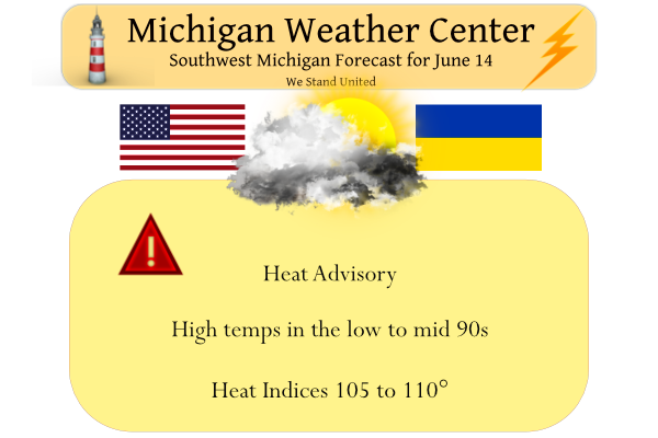
If you have stepped outside early this morning you have noticed how thick the air is. Dewpoint values are near 70 as well as the temperatures. We had 1.07 inches of rain overnight which gives us 2.31 inches for June. Yesterday’s high was 87° and the low 58°. Today we expect temps to rise into the mid-90s with heat indices in the 100 to 110-degree range. Tonight’s temps will drop to the mid-70s.
What is the heat index?
“It’s not the heat, it’s the humidity”. That’s a partly valid phrase you may have heard in the summer, but it’s actually both. The heat index, also known as the apparent temperature, is what the temperature feels like to the human body when relative humidity is combined with the air temperature. This has important considerations for the human body’s comfort. When the body gets too hot, it begins to perspire or sweat to cool itself off. If the perspiration is not able to evaporate, the body cannot regulate its temperature. Evaporation is a cooling process. When perspiration is evaporated off the body, it effectively reduces the body’s temperature. When the atmospheric moisture content (i.e. relative humidity) is high, the rate of evaporation from the body decreases. In other words, the human body feels warmer in humid conditions. The opposite is true when the relative humidity decreases because the rate of perspiration increases. The body actually feels cooler in arid conditions. There is a direct relationship between the air temperature and relative humidity and the heat index, meaning as the air temperature and relative humidity increase (decrease), the heat index increases (decreases).
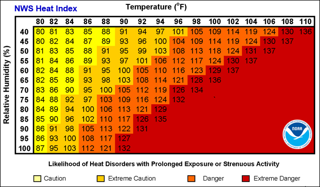
In order to determine the heat index using the chart above, you need to know the air temperature and relative humidity. For example, if the air temperature is 100°F and the relative humidity is 55%, the heat index will be 124°F. When the relative humidity is low, the apparent temperature can actually be lower than the air temperature. For example, if the air temperature is 100°F and the relative humidity is 15%, the heat index is 96°F. These values are taken in the shade. If you are exposed to direct sunlight, the heat index value can be increased by up to 15°.
Forecast Discussion
--Hot and Humid conditions expected through Wednesday--

Except for a lingering shower/storm this morning for Calhoun and
Jackson counties, the convection has cleared the area early this
morning. The low level jet is likely taking advantage of any
lingering instability to produce this isolated convection. This low
level jet will be moving out from here on out this morning.

We are also seeing low clouds developing over the area in the wake
of the rain. The low level moisture from the rain, and the fact that
we are still just north of the warm front is a good setup for the
stratus. After sunrise, we will see the stratus gradually lift, and
mix out. This mixing out will also help to push the warm front north
of the area, and bring in the hot conditions just to our south.

We will not be making any changes to the ongoing headlines for the
heat this morning. The latest trend in the models for temperatures
and dew points is for similar values for both days. This means that
for the southern half of the area, we are expecting heat indices
around 100-105. Up north it looks like they will remain just shy of
the 100 degree criteria. We can not rule out it needing to be
expanded just a little bit, but for now it is not needed.

This heat is obviously the result of the strong upper ridge in
place. The hot air aloft will help to cap the atmosphere through the
daylight hours on Wednesday, and keep the area dry.

The next chance of rain for the area will be Wednesday night. This
chance does not look very good for a couple of reasons. The first
one is that the front will be coming through during the coolest part
of the day when instability is minimized. Second, the upper trough
driving the front just does not make it over the area. It lifts NE
through the UP, but misses most of Lower Michigan. This keeps the
warm temps and cap in place through the frontal passage.

--Cooler for the end of the week with mainly dry conditions--

Somewhat cooler air will be in place on Thursday, but it will still
be warm with 850 mb temps in the mid to upper teens C. So instead of
max temps in the 90s like today and Wednesday, they will be in the
80s with a little less humidity. It will take until Friday fro
noticeably cooler temps and much drier air to move in behind a
secondary cold front Thursday night.

The chance of rain on Friday is not zero, especially to the NE
across Central Lower. This is because we see the polar jet core try
to clip that portion of the area as a short waves dives SE out of
Canada. Sfc ridging and a drier flow from the NE will limit the
moisture, and therefore rain chances. Once that wave moves away from
the area, we should stay dry through Saturday with high pressure
overhead.

--Storm chances increase late in the weekend and early next week--

It looks like a somewhat similar upper air pattern will be setting
up starting Saturday night through Monday as compared to tonight
through Wednesday. An upper ridge will be building into the area
from the West. As this ridge builds toward the area, there will be a
potential for a MCS or two as there are a couple of ridge riders
that try to drop down into the area around the heat dome. Still a
lot of time to watch the trends with those, but it looks like the
heat will be coming back after a break later this week.
Wow, so far June is below normal for temps! Incredible!
Ice Cold Sprites tasting right tonight! InDY
The current temperature here MBY is 90 with a dew point of 79.5 for a very humid day. According to my weather station that is a heat index of 108.
Slim
Dew Point 79 in Grand Rapids. Former Storm Team 8 Meteorologist Kyle Underwood said the record is 81 set in 1995.
24 hours of storm tracking I did talk about being tired some of you may remember Charles Russell “Chuck” from Bills blog he lives in Fort Wayne Indiana now his neighbor is wrecked from the storms last night he even told me this storm was bigger then the 2011 Derachio that hit northern kent County that year crazy! Im Praying for the people that have no power during this heat cant imagine but relief is on the way not going to last thank goodness..INDY
Yeah there was a 98mph wind gust up the street from his house. Insane thunderstorm.
It was a hot and steamy one today. I was in Allegan County all day and it was in the mid 90s with a dew point of 76.
Omega pattern….from this afternoon’s forecast discussion:
–Warm Air Returns Early Next Week–
Gradual eastward shift in Omega pattern aloft results in rising heights and return of H8 air over 20C early next week. Small risk of some convection developing along returning warm front Sunday into early Monday then more 90+ highs and increased humidity expected to start next week.
Well that’s something to not look forward to. Up to 94 here with a 106 heat index. Staying inside today.
Sorry about that. The sun finally came out this afternoon here. Only 83 here currently. Humid as all get out, though.
Heat index 105 in Chicago, 96 in GR and climbing.
Looks like Kalamazoo has a dew point of 79!! That is crazy
Also 79 in Key West – for comparison purposes.
According to MV’s weather station graphic at the bottom right of this page, the current dew point at his crib is 81.9(!).
Wow hopefully MV is staying inside this afternoon :O
103 temp (not heat index) in the West Loop of Chicago.
Really impressive heat now moving into the SW portions of the area and advancing northward. GR up to 95 re-feel. Still cloudy and 81 in Lansing… but starting to feel a bit warm
At the 1PM reading some temperatures around lower Michigan. Grand Rapids 80 with a dew point of 72. Lansing 75 with a dew point of 68. Detroit 78 with a dew point of 61 Here at my house 81 with a dew point of 79. It is much warmer at Kalamazoo with a temperature of 90 and a dew point of 77.
Slim
90 with a 102 degree heat index in Holland. 91 here with 103 degree heat index. Haven’t felt heat like this in some time. Downright smothering out there.
There is a temp reading of 98 with a heat index of 111 in Chicago. Wind speed: 3mph. And it’s only 1:42pm there.
No, thank you.
Yeah, thumbs down on that! 👎
The sun is now breaking thru the clouds at the current time the temperature is 79 with a dew point of 75.
Slim
Hey Slim, where does GR stand for June temp average to date?
After a warm May, GR will soon be standing at a warm June as well. I love it!
After the first 13 days Grand Rapids June 2022 at Grand Rapids has a mean of 64.3 that is a departure of -2.2. For May the mean was 61.5 for a departure of +2.3. April had a mean of 43.6 for a departure of -4.0. March had a mean of 36.2 for a departure of +0.5. February had a mean of 24.6 for a departure of -2.0 and January had a mean of 20.2 for a departure of -4.6.
Slim
Clouds are sticking around which is keeping the morning temps a bit cooler than previously thought.
If the clouds can move out sooner things will heat up more. I think Grand Rapids will still reach the low-mid 90s, but Lansing may have more trouble with the clouds around for an extra ~1.5 hours. We will see. I am currently in Lansing this week as my dad has COVID.
NWS has Lansing as 88 today and 95 tomorrow. Will be interesting to see if the sun from 3-6PM can heat us up to above 90. I think Grand Rapids will have no trouble reaching the 90s today.
We just hit 80 with a 75 degree dewpoint
It’s only 70 and humid here. Thick heavy clouds overhead.
The sun was out earlier but it is now cloudy here and while not very hot yet it is very humid.
Slim
Nathan
Please make sure your Dad gets any medical attention he needs as soon as possible! I know this first hand!!!
Yes my mom used to be a nurse in the ICU (right before COVID started she quit due to her age). So she is taking care of him! Thank you!
Oh good Nathan!!! Hope he feels better soon!!!
Hope he is feeling better soon!! I will keep him in my prayers.
After this blowtorch, WOOD now has 88 degrees again early next week. So I hope you like it hot!
It is now summer so I would expect it to get hot/warm from time to time. Just like in the winter it gets cold/with snow from time to time. With most of us living in Michigan it gets that way every year.
Slim
Phew! Here comes the heat! In fact, today will already be our third warm day in a row.
Looking ahead there are hints that we well see a similar set up early next week with a change of some storms and a shot of hot/warm temperatures. If the latest guess from the CFSv2 plays out the warmest week compared to average may come in the last week of June to the start of July. That is still a ways off so that may or may not change.
Slim
Yesterdays official H/L at Grand Rapids was 85/60. There was a reported 0.17” of rain fall and 60% of possible sunshine. Here at my house I recorded 0.25” of rain fall. There was thundershower late last night. Most of the storm reports were to the south of here and there were some locations with over one inch of rain fall. The overnight low in MBY was 67 and that is the current temperature with cloudy skies. For today the average H/L is 79/58 the record high of 96 was recorded in 1984 in more recent times it was 94 in… Read more »
What a light show last night. It went on for well over an hour. Best lightning in these parts in several years.
There was a some good distant lightning here but not all that much rain and for the most part just a garden type thundershower. Only 0.25″ here at my house and just 0.17″ reported at GRR. So I guess the Grand Rapids area is still waiting for a good nighttime thunderstorm. Odd thing is I thought we would get one last night.
Slim
Not too many CTG strikes, but tons of bolts streaking through the clouds. It was beautiful. Looks like we got about a half inch of rain in the area. Better than nothing, for sure. The real action was down in the moderate risk area.