Not much rain yesterday or overnight, we had a tenth of an inch in Otsego which brings our total to .39 for the month. I was digging holes for posts yesterday with the post hole diggers and the moisture in the soil was about a foot down which gives a good depiction of how dry it is. We are going to have to have a lot of rain to get caught up. Our next chance of rain doesn’t come until Tuesday night though it is only a 30% chance. With increasing temps, our drought issues will only increase, plus the low moisture content in the soil will cause increases in our temperatures. On the plus side, I have seen zero mosquitoes this spring thus far.
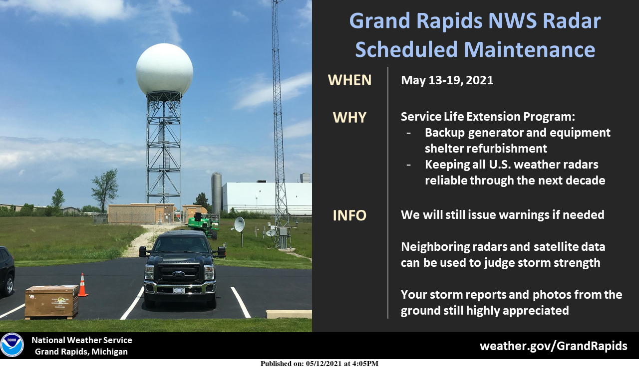
Our radar in Grand Rapids will be down for approximately one week as it receives preventative maintenance as part of a national program to keep our radars healthy for the next decade. The chance of storms is fairly low, but if we do get any next week, we will still be able to see the middle and upper portions of the clouds using neighboring radars. You probably won’t notice much difference on your favorite website or app if it uses multiple radars to create a regional image.
I use Radarscope for storm tracking and have had to use overlapping from Detroit and Chicago radars. Of course, this hasn’t been an issue this spring due to no storms to track.
Forecast Discussion
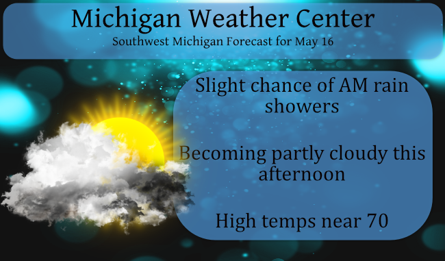
-- Some showers this morning --

An upper shortwave can be seen in the water vapor imagery this
morning moving east over Lake Michigan at this time. Regional
radar loops show showers located ahead of the shortwave over much
of the GRR forecast area. Activity behind the shortwave of
Wisconsin is pretty much non existent. Feel that showers will
continue to press off the east this morning. The showers should
come to an end during the midday hours. Following the HRRR
guidance which shows the showers ending by about the noon hour. We
should see increasing amounts of sunshine in the afternoon,
especially in the south and west with skies at least becoming
partly sunny.

-- Dry on Monday, with chances for rain thereafter --

Dry weather looks to persist into Monday and Monday night with
ridging developing both at the surface and aloft. As we work
through the week, there are certainly chances for showers. On
Tuesday some moisture begins to work back into the area with at
least a chance for scattered showers. Scattered showers will
remain possible almost each day from Wednesday through Saturday.
Moisture continues to increase in terms of an uptick in surface
dew points. The issue is that there is no significant forcing
mechanism in terms of a surface front or stronger shortwave aloft.
So, we only have chance type pops here and there throughout the
bulk of the Wed-Sat time frame.

-- Warming trend continues --

The warming trend will continue with 850mb temps rising a bit each
day. We are +5C aloft at midday today, rising to near +10C on
Tuesday and to near +15C by Friday. We will see highs rise from
the 70s to start the week to well into the 80s by mid to late
week. We have certainly escaped the drum beat of frost and freeze
Must be fantastic weather, Rocky has disappeared!! Keep the fantastic warm weather going!!
As per Bill on Twitter: “At least mid 80s for West Michigan (cooler at the lake)…could be upper 80s to even 90. Record highs are mostly low 90s for G.R. now.”
https://twitter.com/bsteffen/status/1393806209308930048
I recorded just 0.14″ of rain fall last night and overnight. The overnight low here at my house was 51 so much warmer than in the last week or so. The lack of rain and the cold have kept the mosquitoes at bay for now. As stated if the dry conditions continue as we get into June and July we will have a chance of some days that can get warmer then they would other wise but the nights would also be cooler as well and the humidly would be lower. So a day of 85 while warm would not… Read more »
Exactly the same amount squeezed out here at 0.14”. Old saying that holds pretty true is drought breeds more drought. Flip side is true as well, wet and rain breeds more wet and rain, which we saw last year. Not looking forward to the possibility of upper 90’s this Summer.
“Of course, this hasn’t been an issue this spring due to no storms to track.”
Ain’t that the truth?