We have 11° this morning in Otsego (at 6:30 am) with a dusting of new snow overnight. Yesterday’s high temp was 18.5° with a low of 10°. We will see another cold and mainly dry day today. The region will see increasing wind with gusts near 30 mph. Then temperatures will rebound to about the freezing/melting point on Wednesday. Some light snow is possible at times Wednesday. Most of the region will see an inch or less of accumulation. A small chance for light snow exists for the end of the week as an arctic airmass returns to the region.
The CPC is suggesting below normal temps right into the first week of February with mainly below normal snow, though precipitation guesses seem to change daily.
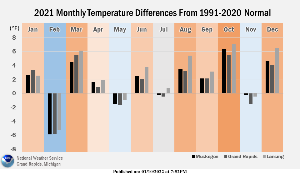
In 2021, relative to the past 30 years, there were more warm months than cold months, and the warm months were often really warm. Averaged across multiple stations in central-southwest Michigan, 2021 ranked the 3rd to 6th warmest of the past 127 years.
Forecast Discussion
- Cold Start to Today

Lake effect cloud cover has helped insulate the lakeshore somewhat
compared to the cloud free interior. Temps beneath the cloud deck
along the lakeshore still hover around 10F, while areas that have
scattered out have dropped down to around 0F already. These lake
effect clouds should hold steady through the rest of the morning and
will help keep temps above 0F, while areas free of cloud cover will
play victim to radiational cooling, dropping down into the -5F to 0F
range. Winds should stay fairly light and variable until daybreak,
so wind chill values will hold to around -10F to 0F across the area.

- Breezy Winds With Warming Temperatures into Wednesday

Today will start cold, but it`ll end mild with rising temperatures.
High pressure will shift into the Ohio Valley setting off
southerly flow and a surge of warm air advection. Temperatures
will continuously rise throughout the day today hitting the mid
20s to low 30s near midnight. By Wednesday afternoon we will see
temperatures peak closer to normal in the low to mid 30s.

Southerly winds will build today into Wednesday with gusts up to
30- 35mph across the area this afternoon and tonight.

- Low Chance for Snow Wednesday, Otherwise Dry Much of This Week

A weak shortwave will dive southwest into the region Wednesday
with an associated cold front. This weak clipper system will bring
a small chance for some light snow, but lack of moisture should
keep most areas dry.

- Clipper System Friday/Saturday, Then Possible Lake Effect

Growing model consensus continues to track the Friday/Saturday
clipper system to our south, so much of the associated snow
should stay to our southwest. Ensembles corroborate this thinking
with more and more ensemble members from both the GFS and Euro
indicating minimal snow. This system is still worth monitoring in
case of a northward shift, but trends suggest southwest lower MI
may be in the clear.

An upper troughing regime will move in overhead with multiple
shortwaves bringing chances for synoptic snow. It`s possible we will
see a little lake effect influence as well following these
shortwaves into the early part of next week.
The cloud cover held the temperatures up last night and the low both here and officially at GRR was +9. There was a trace of new snow fall the official January total still stands at 19.0″ for the season it remains at 38.8″ and here at my house there is 7.5″ of snow on the ground. At this time it is cloudy and 13 here.
Slim
We drove in Sunday to Boyne mountain shuuu it hasn’t stop snowing yet …..Amazing Winter we have going..InDY
Who knew!