A spring-like weather pattern will bring rounds of showers and thunderstorms starting Thursday night and continuing through Friday night. Some of the rain may be heavy and parts of the area could see over one inch of rain. Gusty winds over 40 mph will develop Friday night and continue into Saturday. After highs around 60 on Friday, Saturday’s highs will only be around 40 degrees.
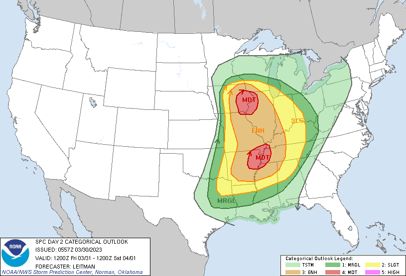
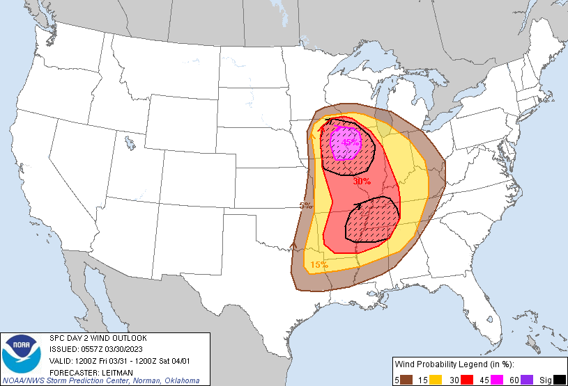
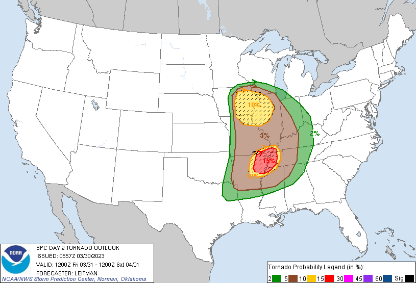
A Moderate Risk of Severe Thunderstorms is forecast for Fri (03/31)
Intense and widespread severe thunderstorms are expected Friday afternoon into the overnight hours across portions of the Middle Mississippi Valley and Mid-South vicinity, eastward to the Lower Ohio and Tennessee Valleys. Intense, damaging gusts and several tornadoes (some strong and long-track) are expected.
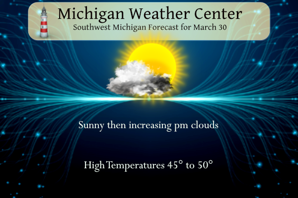
Grand Rapids Forecast
Lansing Forecast
Kalamazoo Forecast
3 30 kzoForecast Discussion
-- Showers and storms tonight with a brief mix possible North --

We are looking at the proverbial calm before the storm for today.
High pressure over the area this morning will slowly build east
through the day. We will start out with clear skies and light winds,
giving way to increasing clouds through the day.

A warm front that will become better defined to our south this
evening and tonight will help to become a focus for shower and storm
development tonight. Helping its cause will be a low level jet that
will be strengthening to almost 60 knots, and nosing into the area
overnight.

The models are in good agreement that the precipitation will break
out across the northern portion of the area first at the nose of the
low level jet. The first few hours of precipitation north of I-96
could be a brief wintry mix, with areas along and north of U.S.-10
the most likely area for it. This is the case with evaporative
cooling taking place as the column saturates from the initially very
dry atmosphere. Accumulations should be limited, with little to no
impacts expected.

Eventually after 06z tonight, all areas should get in on the
precipitation as the entire warm front lights up with showers and
storms. We will remain on the north side of the warm front until
late tonight, before it moves north through the area. Being on the
north side of the front, all convection will be of the elevated
nature. This will keep severe chances quite low with some small hail
being the main threat along with heavy downpours.

-- Showers and storms Fri/Fri Evening then Strong Winds Developing --

A good chunk of the daylight hours on Friday will actually be not
raining, but more of a scattered variety of a few showers and
storms. This will be the result of the first low level jet core
moving east, and the next one that will be ramping up later in the
afternoon to our SW. We will see the coverage increase late Friday
afternoon, and peak Friday evening. This is when the main low level
jet ramps up, and the front moves into the area.

Regarding severe weather potential, we agree with the SPC Day 2
outlook thinking that the threat is low here, but not zero. This has
really been the theme from the various models for multiple days now.
The area that is highlighted for severe weather toward the Quad
Cities definitely has more going for it there. The front will be
coming into that area around peak heating, allowing for plenty of
sfc based instability with limited convection there early Friday. As
the front approaches SW Lower, sfc based instability really drops
off. Part of this is likely the loss of diurnal heating by the time
the front gets here, and additional convection that will form here
Fri afternoon that will limit the low level instability.

There will be plenty of instability here for convection. It will
just be of the elevated variety with fcst soundings showing somewhat
of a stable layer below 900 mb. The bigger concern may be the threat
of wind that would be more of a combination of strong wind fields
and the front coming in and mixing it down, vs. pure convection. The
marginal over the SW corner of the area is good in case convection
from our SW maintains its strength just long enough to clip the area
before weakening.

Once the front moves through then, we are looking at quite strong
wind gusts, which look to be strongest over the lake where there is
limited friction. Wind progs show that 40 mph looks likely, with
some potential that lakeshore communities could see up to 60 mph
winds. These winds would be strongest immediately behind the front,
and would slowly diminish on Saturday as the system and the
pressure gradient lifts out of the area.

The strong winds will be ushering in much colder temperatures, which
will help bring the stronger winds down from aloft. The colder air
will be sufficient enough to change the precipitation over from rain
to snow as it is winding down. The trend over the last couple of
days is for less and less snow potential the further south you go.
The better accumulations will stay well north of the area across far
Northern Lower and the UP.

The precipitation, gusty winds, and cold air will all lift out of
the area by Sunday. This will allow dry and mild air to return to
the area, and last into Monday with a zonal flow from the Pacific.

-- Potential strong storm system Tue/Wed next week --

The zonal flow that will keep things quiet and mild Sunday-Monday,
will give way to a strong upper low that will dig SE from the Gulf
of Alaska and across the Rockies by Tuesday. This will bring SW flow
to the area, which is usually a warm and wet flow for Lower Michigan.

We could start seeing showers and a few storms across far Southern
Lower as soon as Monday night as a warm front takes shape once again
to our south. Eventually, more moisture will be drawn north out
ahead of a strong sfc low developing with the upper low lifting into
the Plains. This looks to be a very strong and dynamic system.
Indications are right now that we would get solidly into the warm
sector, and potentially see very warm temps move in by Wednesday.
This would be accompanied by more showers and storms. A severe
weather outbreak is likely with this system, and Lower Michigan
could eventually get in on it. Still very early yet for those kinds
of details, but the potential is there.
Updated Day 2 severe outlook:
https://www.spc.noaa.gov/products/outlook/day2otlk.html
Thanks Kyle, now looks like GR is on the border line for a slight risk.
Slim
We are also on the border of warm/cold in the CPC outlooks, so I’d imagine an active storm track will continue
You’re welcome slim.
Both Ryan Hall and Reed Timmer said this is a pattern that only comes around once in a while. Ryan Hall thinks its about a once every 10 years type of spring storm season.
It looks like the official low this morning here in Grand Rapids was 17 that is the 9th coldest low for any March 30th. The low here in MBY was 16. The official low of 18 at Lansing was the all time 14 coldest, Going back to 1950 it would be the 5th coldest. The official low of 19 at Muskegon was the 6th all-time coldest.
Slim
Cold, cold, cold!
Late March and only 34 degrees at 12:45 pm! Wow just wow! Winter keeps going and going! Keep your winter coat handy!
The latest parameters for Western Illinois and Eastern Iowa off the HRRR look like a classic tornado outbreak type setup. These supercells would be very fast moving as well therefore fast moving tornadoes. Still going to analyze things and make a decision by early tomorrow AM if I’m going to chase in case details change.
I think we can say that for the most part the winter of 2023 is over. We can still see snow and it can and will get cold. This winter was a mostly mid winter with several rounds of heavy snow fall at some locations. The AWSSI winter comparisons only go back to 1950. As for how many times one wears a winter coat that is a personal preference. I have worn a winter coat in Florida in the winter time. Yes it can get “cold” in Florida in the winter. Temperatures in the 30’s are cold no matter where… Read more »
Look at the severe weather risk from the NWS you can clearly see the cold lakes being the shield again this will be the norm for awhile going into Summer as the cool lakes protect western Michigan alot during the Spring… But loving the fact I am seeing thunderstorms close …INDY
Hey INDY, that’s what I’m looking forward to as well! Some nice big Thunderstorms to roll through! Might be tracking some tomorrow night! Might be out on the porch with a nice tall pour and watching the light show!
Im Ready tomorrow night is looking more interesting but Tuesday looks even better so definitely we are turning the season to thunderstorms bring it …INDY
Completely agree!! More April Thunderstorms = a bumper crop of morels too! It’s INDY tracking time!!
I have been wearing my good winter coat for most of the last 4 months! We have had some very cold mornings! Wow to the wow!
Wow, almost April and the current wind chill in GR is in the mid teens! Now that is COLD!
Wow, I may just have to make the drive to Davenport, Iowa tomorrow morning. Will review things later today. Looks like a significant severe weather event.
Significant serves weather event ? That would make me stay as far away as possible! Nothing worse than a deadly tornado!
Woah, our long hard winter continues! Get ready, after having lows in the mid teens last night, we have rain and snow showers coming on Saturday with temps in the upper 30’s and 40 MPH winds! More cold will be coming the week of April 6th via the latest CPC! The winter weather just keeps coming and coming! Wow just wow!!!
Woah Lansing is now in the top 10 of weakest winters ever recorded.
I believe that. Only needed to wear a winter coat twice all season. Used the shovel just three times. Never dropped below zero. My gas bills were much cheaper than most years.
Woah! I loved that we didn’t see any arctic outbreaks the entire winter.
I don’t want to sound mean…but I will tell you that Blizzard Warning was pretty darn cold!!! I know I didn’t like being out in that. I know we have had colder for longer periods, but that was pretty awful for about 3-4 days here.
That was definitely a severe arctic outbreak with heavy snow! Incredible winter!
For the record, I did not venture outside during that event. I am confident that it would have been the third time needing a winter coat.
For me personally, I don’t really notice a different between a cold or warm winter. A warm winter still has highs between 30-45 degrees, and that is far too cold to do tennis or biking. My lifestyle from November-March is typically the same whether it is a warm or cold winter
Nathan, I agree with you 100% If the sidewalks are mostly clear I walk outside every day. The good news is I walked out most days this past winter but than again I have been wearing a winter coat since November.
Slim
If using the AWSSI chart for winter comparisons that chart only goes back to 1950. Weather records at Lansing go back to 1864.
Slim
Here comes another warm front! 60 degrees and thunderstorms! And only 2 days with more than 2″ of snow on the ground the past 7 weeks. I love short and mild winters!
Tigers will be in the middle of the pack! The Lions have a better chance of winning the division this year than the Tigers! That may be the first time I have ever said that in my lifetime! Incredible!
What a winter! I still have snow on the ground and the low was in the mid teens last night and GR is now over 110 inches of snow! A very snowy and long winter! Wow to the wow, WOW!
15 degrees last night out at my hood thats crazy with April 2 days away.. Slim I put 50 on the Tigers to win the central it pays 12 hun probably thown 50 away lol…but its definitely nice to see baseball being played Spring is here ….INDY
It looks like the worst of the storms will stay to our SW on Friday. We also have yet another system for next week to keep an eye on.
Slim
With a clear sky and calm winds it sure did get cold here overnight. The low here in MBY fell to 16 and that is the current temperature. It looks like the official low for Grand Rapids will be 18. Lets hope that this is the last night that drops down into the teens until late fall.
Slim
The official H/L yesterday was 39/23 That high was reached at 8:30 AM before the snow moved in. There was 0.08” of precipitation and 0.06” of snow fall. There was 55% of sunshine but that did not help with a cold wind during the day. For today the average H/L is 51/31 the record high of 76 was set in 1910 and the record low of 1 was in 1954 the record snow fall of 3” was in 1928. Last year the H/L was 58/33.
Slim
The Tigers open down in Tampa today. I hope I am wrong but I do not see any improvement from last years team. In fact I think they may have moved backwards. But we shall see.
Slim