
Though it is not unheard of I hadn’t excepted these headlines quite this soon which generally has been in mid-October the past few years. Looking at the area matrixes for the state we could see the upper 30s south of I96 and at or near freezing north of I96. Some of the lower colder spots could drop into the upper 20s. These cold temps may be around for the next three nights. Daytime highs will be in the low to mid-60s through the weekend.
Forecast Discussion
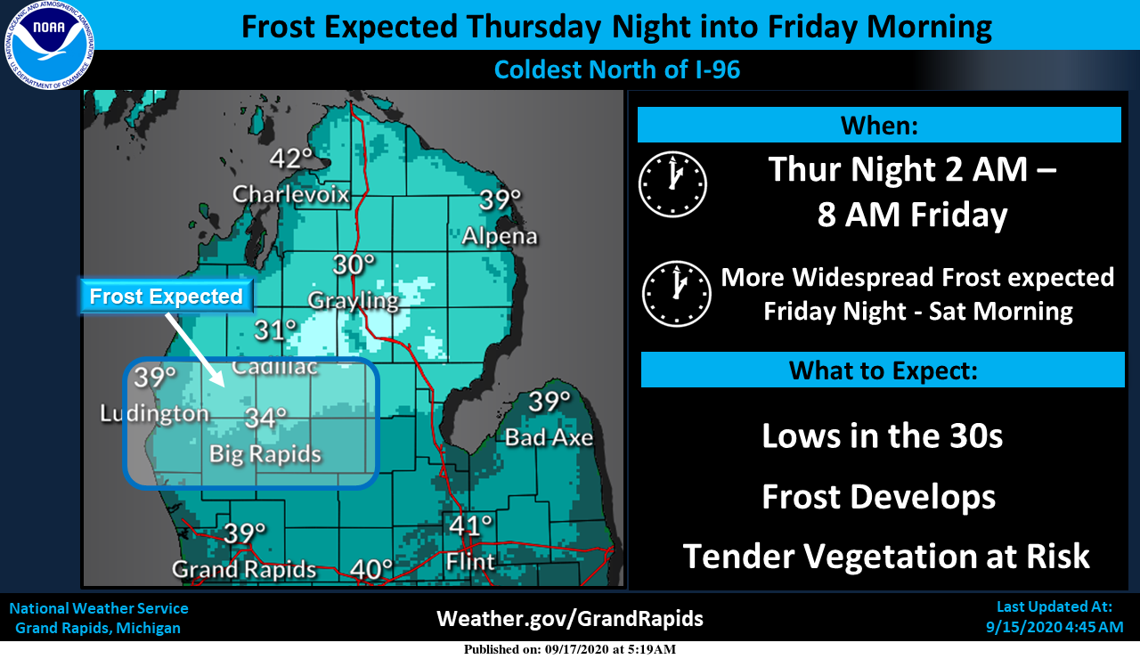
-- Cool through the weekend; nighttime frost threat --

Cold Canadian sfc high building in from the northwest brings
chilly fall-like conditions into the region through the weekend
with a risk of frost at night. Friday night will be the coldest
night when the center of the sfc high will be overhead.

Clear to partly cloudy skies and dry conditions will prevail the
next several days and we`ve probably seen the last of the smoke
aloft issue for a while per HRRR experimental guidance. Visible
satellite imagery from yesterday confirms mostly smoke free skies
under the approaching sfc high as the smoke guidance has been
suggesting.

Frost threat begins tonight, mainly across the nrn zones where
sfc winds have the best chance of calming out. Some concern
exists however regarding extent/coverage of strato-cumulus pouring
swwd off Lake Huron and the HREF low cloud guidance does hint at
that potential.

Will issue a Frost Advisory for the nrn two rows of the GRR CWFA
where confidence is highest, although it`s possible some patchy
frost will develop south of that too if the winds drop off enough
and skies are clear.

Frost threat increases for Friday night and more of the area will
be impacted, so a Frost Advisory may be needed for the entire
area. Also a risk of freezing temps may develop across Osceola
and Clare Counties. There will still be a frost threat on
Saturday night as the sfc ridge holds, but we could have some mid
and high level cloudiness coming in by that time.

-- Temps rebound next week, still dry --

Guidance continues to indicate a warm up next week as upper trough
lifts out and the sfc high pulls away. Still no signs of any
substantial rainfall though as a dry air mass still prevails.
The updated long range guess from the CPC is out and they are thinking that this fall will be warm and for the winter the idea is for a equal chances on the temperature (think near average) but their thinking is for a wetter than average winter season and into the spring. We will have to see how that plays out. With sunny skies and no noticeable smoke the temperature here is 66.
Slim
Incredible cold!
With frost advisories and lows in the 30’s the next 3 nights now is a time to look back. For Friday AM the record low at Grand Rapids is 35 set in 1973. It got down to 36 in 1974. The last time the low was below 40 on September 18th was a low of 38 in 1995. For Saturday AM the record low is 36 set in in 1979, 1929, 1902. The last time it got below 40 on the 19th was 39 in 2012. On Sunday AM the record low is 33 set in 1956 and the last… Read more »
Wow we could easily see records broke this weekend in Grand Rapids that’s for sure … Thanks slim for the stats …INDY
GREAT SCOTTY…Frost and Frezze advisors!! Turn the heat up!! ..Lets hope mookies poool is heated lol…We will call this hoodiee upp Thursday it’s cool outside but fresh I would take this Fall weather all summer long the best … Enjoy our below normal September we have on going INDY ….
Mookie is swimming and Barry is running his ac 24/7! Some things will never change!