As most of you know forecasting winter storms can be challenging especially in the Great Lakes region where the warmer waters of the lakes can cause enhancement of snow accumulations. Temperature differences on either side of the lakes can be colder or warmer due to cloud cover generated lake breezes or lack thereof.
Having lived in the northeast and in Michigan I have experienced a wide variety of winter storms – noreasters can be much worse than lake effect. I remember discussing noreasters with Craig James many years ago if I remember correctly he was stationed out there when he was in the Service. In the northern areas of Maine on into Quebec, they can drop feet of snow rather than inches we get in our area from lake effect.
Forecasting Winter Weather
Accurately forecasting winter weather is a complicated process. It starts with a wide network of observing systems such as satellites, Doppler radars and automated surface observing systems. Computer forecast models take this information and estimate what will happen next. Forecasters then use their experience to write and issue forecasts.
Knowing the climatology for a given area is very important to be able to forecast winter weather. Winter storms come in different sizes and are created by different combinations of atmospheric conditions and local geography.
Mid-Atlantic Coast to New England
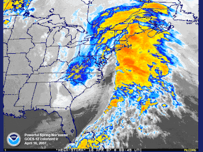
A classic Nor’easter [+]
The classic storm is called a Nor’easter. A low-pressure area off the Carolina coast strengthens and moves north. Wind-driven waves batter the coast from Virginia to Maine, causing flooding and severe beach erosion. The storm taps the Atlantic Ocean’s moisture-supply and dumps heavy snow over a densely populated region. The snow and wind may combine into blizzard conditions and form deep drifts paralyzing the region. Ice storms are also a problem. Mountains, such as the Appalachians, act as a barrier to cold air trapping it in the valleys and adjacent low elevations. Warm air and moisture moves over the cold, trapped air. Rain falls from the warm layer onto a cold surface below becoming ice.
Gulf Coast and Southeast
This region is generally not used to snow, ice, and freezing temperatures. Once in awhile, cold air penetrates south across Texas and Florida, into the Gulf of Mexico. Temperatures fall below freezing killing tender vegetation, such as flowering plants and the citrus fruit crop. Wet snow and ice rapidly accumulate on trees with leaves, causing the branches to snap under the load. Motorists are generally unaccustomed to driving on slick roads and traffic accidents increase. Some buildings are poorly insulated or lack heat altogether. Local towns may not have available snow removal equipment or treatments, such as sand or salt for icy roads.
Midwest and Plains
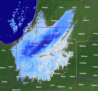
Lake effect snow [+]
Storms tend to develop over southeast Colorado in the lee of the Rockies. These storms move east or northeast and use both the southward plunge of cold air from Canada and the northward flow of moisture from the Gulf of Mexico to produce heavy snow and sometimes blizzard conditions. Other storms affecting the Midwest and plains intensify in the lee of the Canadian Rockies and move southeast. Arctic air is drawn from the north and moves south across the Plains and Great Lakes. Wind and cold sometimes combine to cause wind chill temperatures as low as 70 degrees below zero. The wind crosses the lakes, tapping its moisture and forming snow squalls and narrow heavy snow bands. This is called “lake-effect snow.”
From the Rockies to the West Coast
Strong storms crossing the North Pacific sometimes slam into the coast from California to Washington. The vast Pacific provides an unlimited source of moisture for the storm. If cold enough, snow falls over Washington, Oregon and California. As the moisture rises into the mountains, heavy snow closes the mountain passes and can cause avalanches. The cold air from the north has to filter through mountain canyons into the basins and valleys to the south. If the cold air is deep enough, it can spill over the mountain ridge. As the air funnels through canyons and over ridges, wind speeds can reach 100 mph, damaging roofs and taking down power and telephone lines. Combining these winds with snow results in a blizzard.
Alaska
Wind-driven waves from intense storms crossing the Bering Sea produce coastal flooding and can drive large chunks of sea ice inland destroying buildings near the shore. High winds, especially across Alaska’s Arctic coast, can combine with loose snow to produce a blinding blizzard and wind chill temperatures to 90 degrees below zero! Extreme cold and ice fog may last a week at a time. Heavy snow can impact the interior and is common along the southern coast. With only brief glimpses of the winter sun across the southern horizon, the snow accumulates through the winter months. In the mountains, it builds glaciers, but the heavy snow accumulations can also cause avalanches or collapse roofs of buildings. A quick thaw means certain flooding. Ice jams on rivers can also cause substantial flooding.
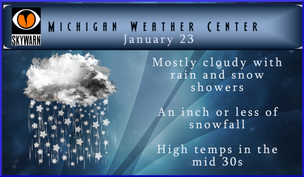
I hope you enjoyed the sun yesterday – we won’t be seeing much of it for a few days. We have chances of snow and or rain right on through Sunday, however not much of either is forecasted. No big storms on the horizon, just another typical winter day (for this winter anyway). Luckily we won’t see it raining iguanas like they had in Florida. I used to have an iguana and other lizards, they like to keep warm and will go dormant if they get cold. My big goldfish in the pond outside go dormant in the winter and come back to life when the water temps get above 40° or so.
Winter isn’t over yet. We have 2 months to go yet. We are sure to get our share of snow someday. 🙂
The snow this weekend is gonna be close, the temp is close to being snow, I wouldn’t count out 2-4 inches for us yet, I hope not, but it’s close enough to make my butt pucker!!!!! Snowplow life!!!!!
Guess my snowblower is going to start collecting dust again. Well that one time I used it this year, was really worth it!
Plus my snow shovel . Great news !!
Made 40 at my house, 39 in GR!! Blew way past the forecasted highs for today!! Melt, Melt, MELT!!!! Keep on ROCKIN!!
Love these short winters!!
More snow is in our forecast! Imagine that! Incredible!
Oh yeah tons!!! Amazing!!
http://wxcaster.com/gis-gfs-snow-overlays2.php?STATIONID=GRR
Lol.
haha Less than 0.5″ for GR over the next 5 days! Wow, Rocky is really trolling harder than usual today.
Remember Mookie, you have to divide those totals by 4 because those maps are always 4 times over done!
CPC is still well above normal into the second week of February too! Make Winters Short Again!
Awesome news !!
Currently 38 degrees and we are seeing more melting today. Imagine that!
Thanks Mike and Slim for the weather factoids:) I love all things related to weather. When I was a young teen growing up in Minnesota, I had a “weather relay room” (lol), which was loaded with all of the high tech weather forecasting tools/gadgets that the late 1970s had to offer (this included a min/max mercury thermometer, aneroid barometer, sling psychrometer, and a cheap wind gauge that I mounted on a stick attached to the bird house in the back yard. Pretty sure the birds used it to calculate their wing beats when exiting/entering their little home… When I could… Read more »
Growing up on the east side of the state in Bay City and Alpena where there is less lake effect snow fall. (Alpena get some lake effect Bay City very little) but both locations get system storms with NE winds. While not on par with the east coast Nor’easters the storm on the east side of the state from the thumb to Alpena can drop a lot of wind driven snow. I have seen many storms over there with NE winds of 55 to 75 MPH with heavy snow and many times thundersnow (I have only seen one thundersnow storm… Read more »
👍
31 with very light snow falling here at this time. Just a trace of new snow with around 5″ of old snow on the ground.
Slim
We are still a foot below average snowfall and the first two thirds of winter has been very mild. 37 days until meteorological spring!
Now just wait a minute is that more snow falling outside according to berry the snow would be gone by now and temps in the 40’s or was that last year post I was thinking about hmmm lol….Im confused… On that thought Have a super snowy Thursday INDY…