Fair weather with mostly clear to partly cloudy skies is forecast today through this evening. Our next chance of rain and snow arrives Wednesday morning as a cold front moves in. Fair weather returns late Wednesday through Thursday before a strong system brings the potential for rain and thunderstorms Friday into Friday night.
U.S.A and Global Events for March 28th:
1920: The worst tornado disaster of record occurred in Chicago, IL as a tornado killed 28 persons and caused three million dollars in damage. This tornado was part of an outbreak that saw 38 tornadoes hit the Midwest and the Deep South states. Over 380 people died, and at least, 1,215 were injured during the Palm Sunday outbreak.
1935: On this date through March 31st, a great dust storm descended on Amarillo, Texas reducing visibility to zero for a six-hour period.
1963: A decision was handed down in the case of Whitney Bartie vs. the United States of America. Bartie sued the U.S. Weather Bureau for negligence in failing to provide a warning about Hurricane Audrey in 1957. Bartie’s wife and five children were killed after the 12-foot storm surge struck Cameron Parish, LA on the morning of June 27, 1957. It was ruled that the evidence presented did not establish negligence on the part of the Weather Bureau.
1977: A slow-moving storm system affected South Dakota from March 28th through March 30th, 1977. The storm produced heavy snow in the west and thunderstorms in the east. Northerly winds gusting to 50 miles an hour in the West created blizzard conditions as the snow totals mounted. Some areas in western Butte, Pennington, northern Shannon, and Lawrence counties received over 20 inches of snow. With drifts exceeding 6 to 8 feet many people in western South Dakota thought it was the worst blizzard in a quarter century. A few locations in the northern Black Hills received over 4 feet of snow. Because of blocked roads, westbound traffic was halted on I-90, and many schools and businesses were forced to close for several days. Across the eastern portion of the state rains of over 1″ fell in many areas. Milbank even reported walnut size hail.
Grand Rapids Forecast
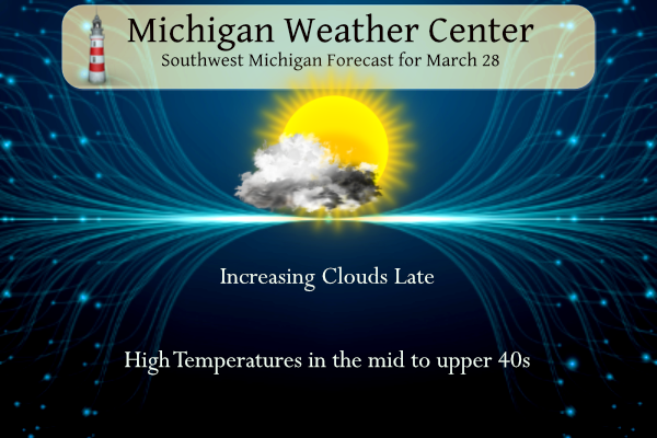
3 28 grrLansing Forecast
3 28 lanKalamazoo Forecast
3 28 kzoForecast Discussion
-- Burst of snow expected Wednesday morning --

We will see another dry and mild spring day across the area today.
There may be a few more diurnal clouds present across inland areas,
as a weak area of low pressure will be passing by to our North.

Of more importance will be a stronger front that will be dropping
through the area Wednesday morning. This front is directly
associated with a strong upper wave that will be diving SE toward
the area. Now this front will not have much moisture to work with,
but the low level forcing with the strong and cold pool aloft will
help to compensate for the lack of moisture.

Snow amounts look to be limited to an inch or so, but it could come
quick in 2-3 hours time. Thankfully for most of the area, it should
come after the morning commute for the most populated areas so
impacts will be limited. Also, sfc temps will be near freezing, and
road temps should not be too cold with them warming up considerably
today with the sunshine.

This front should be gone easily by the evening commute. Snow
showers should be light to non-existent by that time as maybe a few
snow showers with the upper system remain. Temperatures will
probably fall a bit behind the front as much colder air moves in.

-- Wet system Thu night-Fri night changing to snow and windy --

The system expected to come in for the Thu night through Saturday
time frame has been well advertised, with fairly good agreement
amongst the models.

We will see a burst of precipitation develop after dark Thursday
night across the entire area. The various models and their ensembles
have good general agreement in this scenario. That is that mostly
rain can be expected along and south of I-96. North of I-96 there
will be either some snow, or wintry mix of snow, freezing rain,
sleet with a cooler thermal profile up there. This will all be
facilitated by a 50+ knot low level jet that will bring the initial
moisture over the area. It does look like the wintry mix should not
last too long, and change over to mainly rain for all of the area by
12z Friday.

There will be a relative lull in the rain before it ramps up once
again Friday afternoon and evening. This will be the result of a
stronger low level jet associated with the main upper wave lifting
over the region. We will see temps potentially getting into the 60s
across the southern half of the area Friday afternoon and evening.

There will be sufficient instability for thunder Friday afternoon
and evening, with elevated LI`s below zero. Sfc based LI`s are not
quite below zero, with the best sfc based instability staying to the
SW. It looks like our area will be spared the most unstable
conditions with the timing of the front after dark. Still, with the
strong low level jet and sufficient instability, storms will have to
be watched for large hail.

Once the associated sfc low passes east of the area, we will see a
strong gradient set up on the backside, and bring strong wind gusts
over the area to around 50 mph or so. This gradient strengthens as
the low is deepening fairly fast. The strong winds will bring in
much colder weather on the backside of it, and change any rain over
to snow Saturday morning. Areas up north will see a better chance
for accumulating snow with the mid level deformation zone moving
across that area. Temperatures will fall once again on Saturday.

-- Unsettled weather pattern holds for early next week --

We will see a fairly sharp ridge build in behind the system for the
first half of Sunday. This will be short lived as the upper air
pattern then becomes zonal behind the ridge. This means that there
will be ripples in the flow, and chances for rain/snow late Sunday
with one wave, and later Mon with the next wave. It does look to
stay fairly mild for most of the time, except Saturday right behind
the strong system.
Parts of MI will be getting hammered with SNOW this week! Wow to the wow, WOW! Get ready for an April snowstorm in snow country and the UP! Incredible!
Hello SNOW country! Skiing in April! Wow!
https://www.pivotalweather.com/model.php?m=ecmwf_full&p=sn10_acc-imp&rh=2023032812&fh=240
54 has been the warmest temperature this year thats not real warm going into April just saying….INDY
Definitely in a cool pattern with crazy amounts of snow!
What a winter! We have nearly 40 inches more snow than last winter! Incredible snowfall totals this season!
Accumulating snow is in the forecast and it is almost April! Looks like our long winter gets even longer, this after a very snowy and hard winter! Wow, just wow, WOW!
That is not unusual at all. We aren’t supposed to consistently be in the 60’s yet LOL
WOOd now shows multiple days with lows in the 20’s! Wow the cool pattern continues!
Oooh the CPC is starting to creep a little red into Michigan now. Looks like our march into summer begins soon! April could very well be another warm month if the forecasts hold – great news after a very weak winter and consistent warm temps the past year or so.
WOOD now has 5 days out the next 8 with temps 50-58 degrees. Average high is only 50.
The average high keeps going up by about .5° ever day for most of the month of April. Highs in the mid to upper 50’s are common for the first week of April. On the flip side highs in the 30’s and lows in the 20’s are also common in the first week and more of April.
Slim
Took the plow and mounts off my tractor today – time to get the mower attached…
I still have a lot of gas in the snow blower. Will soon have to get the lawn mower ready for the summer.
Slim
I see GR picked up another .1 inch of snow yesterday! The snowy pattern is still rocking!
0.1″ of snow is snowy now? LOL I can get on board with that definition.
Very cold morning! Temps still below freezing! The cool pattern continues! Wow!
According to the CPC, we are right on the border of above/below average the next couple weeks. So probably some warm/cool days mixed in with an active storm track? We will see, but should be interesting.
In the meantime, I’ve been enjoying all of the recent sunshine!
The official H/L at Grand Rapids yesterday was 50/33 there was 013” of rain fall and 0.1” of snow fall. So far the overnight low here in MBY has fallen to 25. For today the average H/L is now up to 50/31 the record high of 78 was set in 1905 and the record low of 8 was set in 1923. The record snow fall of 3.3” fell in 1947. Last year today was a very cold day with the H/L of 33/17 That high of 33 is the 4th coldest and the low of 17 is the 8th coldest… Read more »
Yesterday was a rather nice late March day, While this year had been mostly above average in the temperature department there have not been any real warm days yet this year. The warmest so far at Grand Rapids is just 54 back on February 14th At Lansing the 58 on the same day is the warmest and at Muskegon it topped out at 59. We shall see how warm we get on Friday
Slim
Get ready for the cold, wind and snow on Wednesday! What a wild and snowy winter and it is still going! Incredible!
It looks like March will go out like a lion this year.
Slim
Will March end up with below normal temps?
Not sure about Rockford but it will be another (broken record) above average temp month here.
Nope