It appears we will be entering another dry period with below normal rainfall over the next couple of weeks with temps below normal also. This tells me we could have another stretch of high-pressure domination and a southern jet which will block any systems from moving into Michigan keeping them well south of the state.
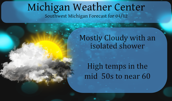
Yesterday we had a trace of rain with just a few sprinkles around the area. Today and tomorrow will be much of the same with perhaps a few peeks of the sun to tease us.
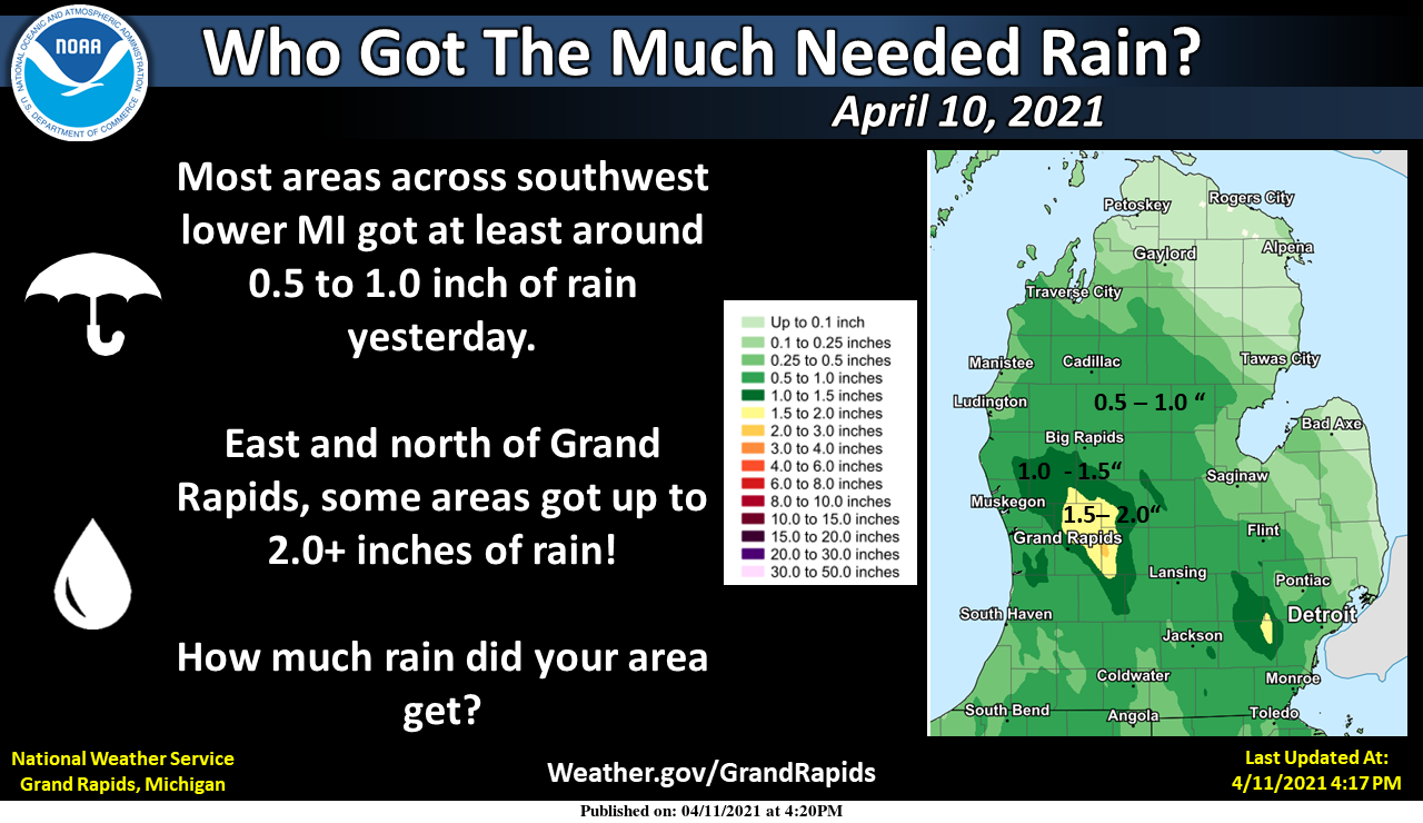
Below are the rainfall totals from the tenth –
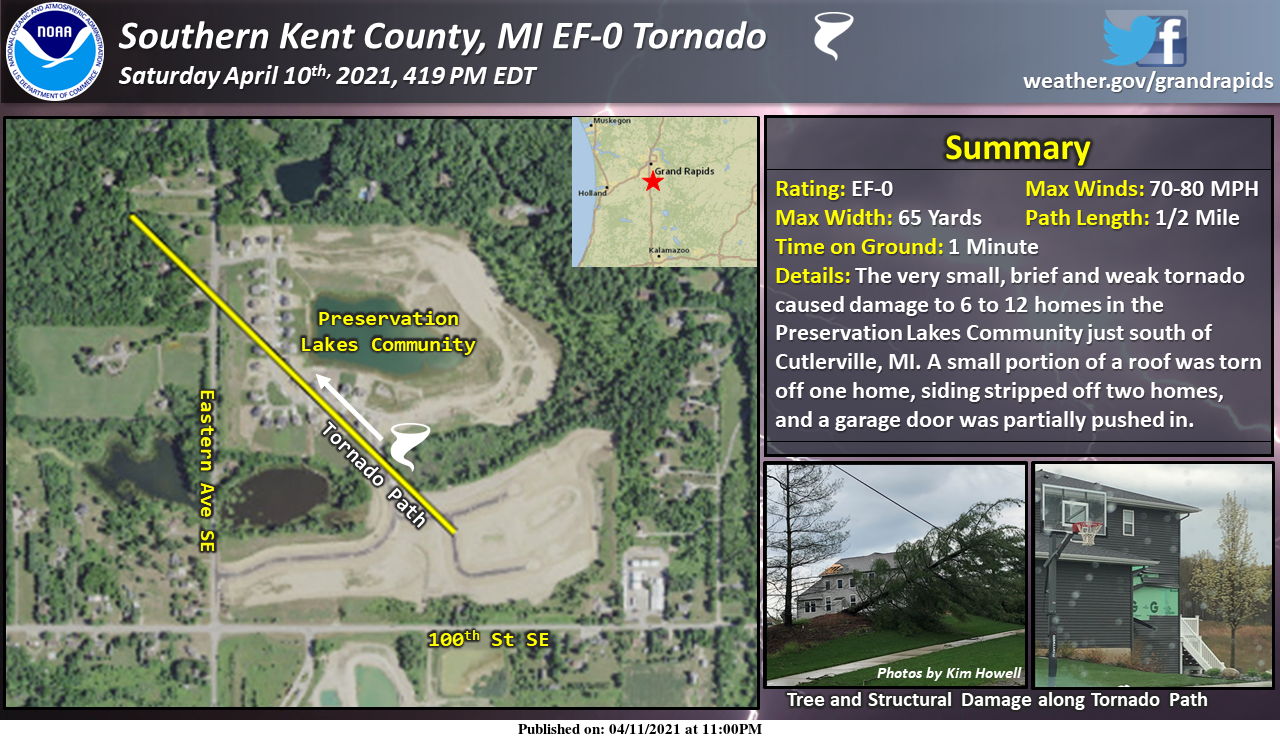
The NWS in Grand Rapids has completed a survey of damage in southern Kent County just south of Cutlerville and east of Byron Center, in Gaines Township. A very small, brief, and weak tornado touched down in the Preservation Lakes residential community, causing damage to 6 to 12 homes. The most notable damage was a small portion of a roof torn off one home, some siding stripped off two homes, and a partially pushed in garage door. Security/doorbell video revealed that objects were lofted and carried through the air. At least two vehicles sustained damage from being struck by flying debris such as lawn chairs.
Forecast Discussion
-- Isolated to scattered showers and colder this week --

The slow moving upper low that meandered it`s way from the southern
Plains is over western Lake Erie this morning. It`s producing some
light rain showers across the eastern Lower as well as southwest
Lake Michigan. A few of these showers over the Thumb may make it
across to central lower today. This upper low will move east today
and be replaced by another upper low that`s moving across the
northern tier of states. This second low will take until Thursday
night to leave the cwa. Given the instability of upper lows created
by cooler temperatures aloft, it`s a pretty good bet we`ll see more
showers as we go through mid week. We`re also going to see colder
temperatures.

Today will probably be the warmest day of the week with highs in the
lower 60s. H8 temps near 4C today will fall to around -1C Tuesday
and -6c Wednesday when the core of the upper low moves overhead. The
ECMWF, GFS, and NAM all suggest that the rain showers may mix with
or change to snow showers as the colder air moves in.

Wednesday will be the coldest day with highs in the 40s. A slow
warming trend will ensue Thursday and continue through Saturday when
we`ll get close to 60.
I’m good with these temps over the next 10 days!! Great morel growing weather and awesome for working outdoors!! Got the other half of my deck to finish up next weekend!
https://weather.com/weather/tenday/l/b4ea0280869baa46799dc75eacef8904785ec43ad2f6fb098355fbc208a55e2c
APRIL 20th – 26th CPC outlook much below normal temperatures for Michigan snow?? who knew ?? INDY
Incredible! Bring on the cold and snow!
Beautiful sunny day in the 60’s today! Just another awesome above average early Spring day that feels more like May.
Just shut the windows has to turn the furnace on to get the chill out of the house… crazy!! It’s April 12!!!!!!!! Lol…INDY
I found a travel site from England that has the weather for our state in it. I think I will post some of that information in this Saturdays post. I think it will give many of us a different perspective as to how some other people view the weather here in Michigan. At this time it is mostly sunny and 62 here.
Slim
I also mowed yesterday. It was long and I probably should have mowed a week earlier.
The average high/low right now is 56/36, so this week looks to be average or a little above average. 57 here now and 60 in GR.
Such a beautiful week of weather ahead plenty of chances of a Wintery mix for the middle of April GREAT SCOTTY!! WHO KNEW??? LET THE BON FIRES BURN ….INDY
I cut the grass yesterday for the 1st time in 2021. The first grass cut date is one day I do not keep records on. But I know that while there have been other years that I started in April I think this is one of the earliest with maybe 2010 and 2012 being others. There looks to be a long period of near to below average temperatures coming up. But that said there is no snow in the forecast so unless we have a late April or May event this year the snow season should be at a end.… Read more »
Fun fact: We would need approximately 40+ days in a row below average just to equal the number of days above average this year.
Be careful of what you wish for. We should be done with this seasons snow fall but it has snowed in Late April and early May. In May of 1954 there was 1.3″ of snow fall on May 3rd and it snow 5 out of the next 6 days. 18 of the next 20 days were below average.
Slim
The only thing I’m really wishing for is that we don’t continue our trend of most of the past 6 months of being above average. I would hate to see a July day at 20 degrees above average. That would be downright miserable!
There has only been one July day 20° day above average and that day was July 13th 1936 and that was the hottest day in Grand Rapids history. In recent times July 6th 2012 was +16.6 and that day the H/L was 104/74.
Slim
Sounds terrible. Definitely don’t want that!
Over night low of 43 when the average low is 37 = above average for those that are confused.
Low of 42* degrees this morning felt wonderful outside weather ball blue cooler weather in view I’m thinking the blow torch is out of gas again lol….INDY
Get ready for below normal temps this week and cold nights! The ground may freeze again?
We picked up about 1.7″ of rain over the weekend. By the looks of the trees, the orioles will be showing up early at the feeders this year.