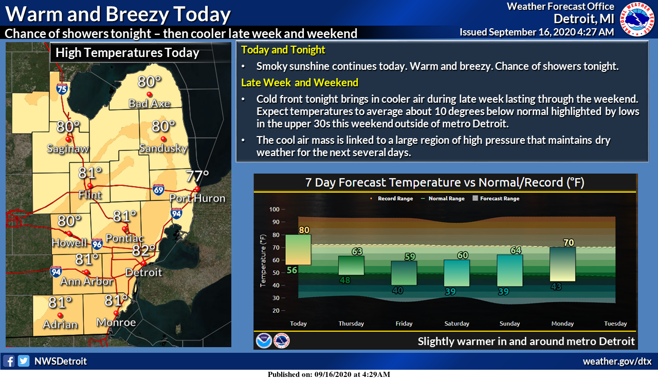
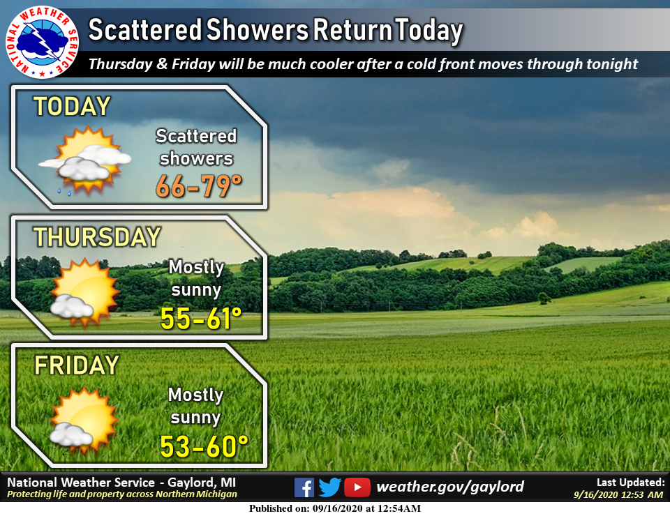
The story for the end of the week is the cooling trend coming from a cold front this evening which will push our temps to below seasonal norms. Normal high temps are in the upper 60s. This will only be temporary as temps are predicted to go above normal next week then below normal as we get into the first week of October. Enjoy the roller coaster ride!
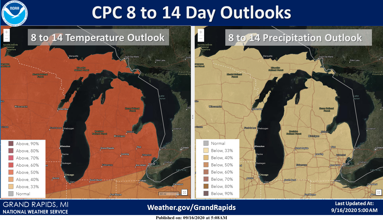
We have expectations of drier than normal conditions through the end of the month. Chances of rain today are less than 20%. Our next chance of rain may be later next week.
[columns] [span6]

[/span6][span6]
[/span6][/columns]
State Forecast
[columns] [span6]

SW
[/span6][span6]
SE
[/span6][/columns]
[columns] [span6]
North
[/span6][span6]
U.P.
[/span6][/columns]
Weather History
September 13
1939: A record breaking heat wave begins with the temperature hitting 95 degrees at Grand Rapids.
1952: Muskegon reaches 92 degrees for their third record high temperature in a row.
1962: A severe thunderstorm struck Lansing with wind gusts over 65 mph, producing light damage across the city.
2008: Five tornadoes strike southern Lower Michigan. Four of the tornadoes were spawned by one thunderstorm. A car dealership and a restaurant were damaged in Paw Paw and weak tornadoes damaged trees near Mattawan in Allegan County, Millers Corner in Kalamazoo County, and Brookfield in Eaton County. Several buildings had roof damage from a tornado that struck Plymouth in Wayne County.
September 14
1928: Tornadoes struck across Lower Michigan. A tornado hit in Mason County south of Scottville damaging at least three homes and injuring two people. The roof of one home was carried over a mile. Another tornado destroyed several barns, killing cattle about 2 miles south of Cedar Springs in Kent County. What may have been a tornado took part of the roof off a factory and warehouse in Grand Rapids.
2008: Ten days after the the remnants of Hurricane Gustav drenched southern Lower Michigan, the remnants of Hurricane Ike brought another round of heavy rain. From 3 to 6 inches of rain caused flooding, with some road washouts.
September 15
1939: A four day heat wave peaks across western Michigan with Grand Rapids hitting 97 degrees and Lansing 94 degrees.
September 16
1886: A swarm of tornadoes hits southern Lower Michigan from late morning into the early afternoon. At least ten separate tornadoes struck, causing damage in Cass, Livingston, Kalamazoo, Eaton, and Clinton Counties. One person was killed and another injured in a tornado that hit Brighton.
1899: Grand Rapids records a high of 98 degrees, setting the record for its hottest September temperature, which would be tied on September 2, 1913.
September 17
1972: A severe thunderstorm produces two tornadoes. The first damages a car six miles northeast of Kalamazoo. The second damages a house three miles south of Middleville.
1973: It was a record cool day as clouds and rain held high temperatures in the 40s across western Michigan. The high of 47 degrees this afternoon at Grand Rapids would be followed by a record low of 35 degrees the next morning.
1977: Two tornadoes struck Lower Michigan. One person was injured in the town of Flushing in Genesee County. Thirty homes and a library sustained heavy damage there. Another tornado hit near Westphalia in Clinton County, damaging a house and a garage.
September 18
1918: A tornado destroyed a large barn about 5 miles southeast of Grand Haven in Ottawa County, and carried the timbers a half mile.
September 19
1997: A line of severe thunderstorms producing wind gusts to 70 mph downed trees and power lines from Allegan County through Jackson County. Around 10,000 customers lost power. A boy in Hastings was injured by a lightning strike.
Forecast Discussion
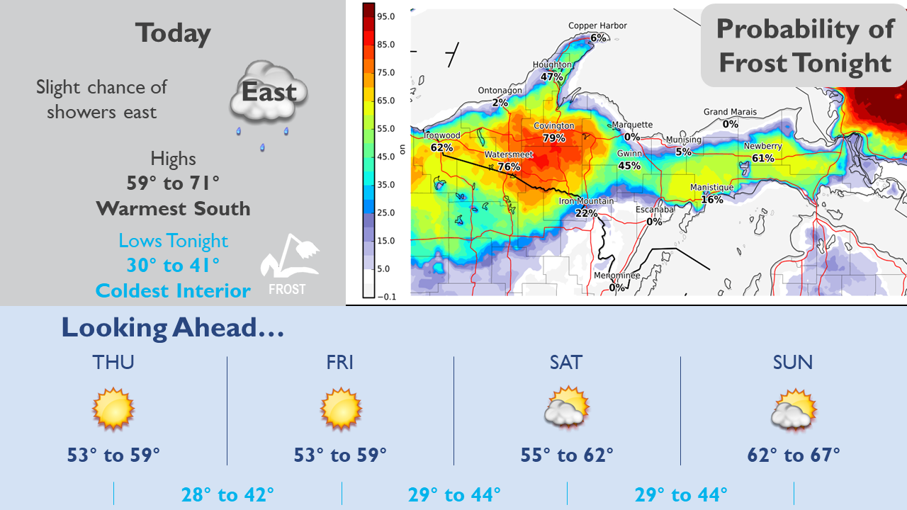
--One more warm day then cool and sunny through the weekend--

Last warm day with highs in the 70s until next week as a cold
front dropping down from the north late this afternoon and evening
ushers in a period of below normal temps. High temps Thursday
through Monday will be in the 60s, with the coldest days being
Friday and Saturday.

A few rain showers are possible with the frontal passage this
evening as a narrow ribbon of PWATs over an inch comes through,
but rain amounts expected to be only a trace to a few hundredths.

Another Canadian sfc high builds in behind the front and the air
mass is very dry (dew points in the 30s/PWATs around 0.25)
leading to sunny days and clear nights. Experimental HRRR smoke
guidance shows the smoke aloft departing behind the cold front as
upper trough digs in, so would expect to see clearer, bluer skies
the next few days after one more day of hazy/milky skies today.

--Frost threat, most widespread/likely on Friday night--

The center of the 1030mb sfc high coming in from the northwest
settles overhead on Friday night and this is when the threat of
frost will be highest. While the coldest temps and the most
widespread frost will be north of I-96, it`s possible the entire
area will have a threat of at least patchy frost as winds calm
out and temps fall into the mid 30s. Some freezing temps are even
possible around Evart and Harrison on Friday night.

A frost risk also exists on Thursday night but there`s some
uncertainty about the northeast winds diminishing enough. The
best chance of that occurring will be north of I-96. There`s a
chance of frost on Saturday night too if the sfc high center is
still close by, although it may be beginning to pull away at that
time.

--Mild temps return next week; dry weather persists--

Ensemble guidance remains consistent on the warm air returning
early next week as the high slips away and southerly flow
develops again. Highs should be back up in the 70s by next Tuesday
but the dry pattern continues to prevail with the Gulf still
shut-off. A front next Thursday could bring some showers but it`s
not looking like much at this point.
Frost abd frezez advisories coming?? Stay tuned…INDY
Get ready for frost and epic cold! Big front will be moving through! Keep it coming!
Went to the store this morning grabbed me 4 furnace filters I’m getting ready…INDY
Rock n roll will never die!
Speaking of football! The lions are the worst pro sports franchise in the world! This past Sunday was the (Sol) same old lions! Another epic game they gave away! This has been happening for over 50 years and no change in sight!
I agree I’m glad I’m a Colts fan …I’m just excited for college football I love MICHIGAN!! INDY
We have BIG 10 football ….Love it ….INDY
Sally made landfall as a Cat 2. Still only moving at 3mph – a walking pace. Saw one met this morning say that Pensacola area could get 25” of rain along with 5-7 foot surge in the bay. Historic flooding is imminent. I could not imagine.
Return back to mild temps and more summer-like weather next week. I love it! Today looks summery too.