
We have 31° at 6 am here in Otsego. Yesterday our high temp was 48.6° with .15 of an inch of rain bringing our monthly total to .30. We also have some fog around the area thus the dense fog advisory until 9:00 am.
We have about a 30% chance of rain for this morning and once again it is predicted to be meager at best. The best chances of rain will come well east of US 131 – the eastern side of the state rain chances increase to 80% so we will have to take what we can get in the dry spring we have been experiencing.
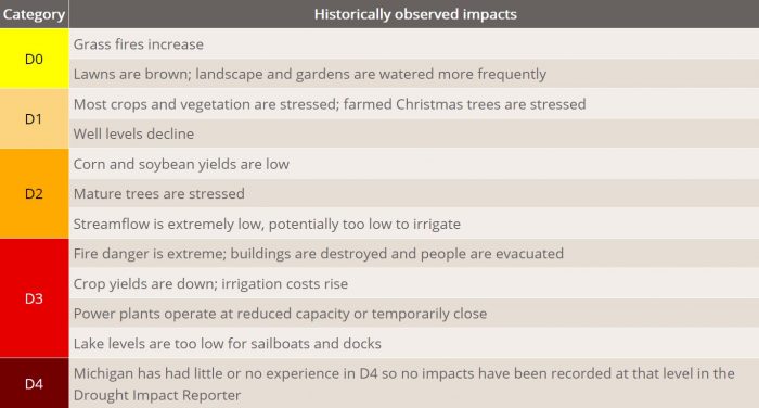
We remain in a persistent moderate drought and without decent rains, it appears we will remain in a dry pattern.
Forecast Discussion
- Areas of dense fog this morning

Areas of dense fog will continue to form this morning under
partially clear skies, light winds, and high dewpoints left over
after rainfall yesterday. The fog will persist for the first part of
the morning commute, before an approaching trough increases mixing
and begins to spread showers into the area. The best coverage of
denser fog is expected east of Grand Rapids, Kalamazoo, and Big
Rapids, but satellite does show some dense patches existing all the
way back to Lake Michigan. In addition to low visibility, drivers
should be alert for slick spots where temperatures fall near
freezing.

- Showers, possibly a few thunderstorms today

Upper shortwaves now dropping through the U.P. and Northwest Ontario
will dive into the area today, sending weak surface low pressure
down across Lower Michigan. Modest area of showers now over
Wisconsin will begin to spread into West Michigan after 5AM, and is
expected to fill in more by afternoon as the system strengthens and
we get a boost from daytime heating. This should allow for a better
coverage of showers roughly east of a line from Big Rapids to Ionia
to Marshall after about noon. A few thunderstorms are possible this
afternoon and evening east of US 131 as models show just enough
instability building. Storms will not be severe with only a few
hundred J/kg of SB CAPE, but dry air from the surface to 3000-4000
feet will support gusty winds capable of dropping a few small
branches. All storms and stronger showers will be capable of
producing graupel with the freezing level only around 3500 feet.
Showers will move east out of the area during the late afternoon and
evening as the low moves east.

- Cool temperatures persist through early next week

Longwave trough anchored over Eastern Canada and New England will
keep reinforcing cold air over the Great Lakes through early next
week. The trough will finally move east on Tuesday, but will be
followed by a cool dome of high pressure setting up over the Midwest
and Central Great Lakes. Temperatures will stay below normal through
this period, when we would normally see highs in the mid 60s and
lows in the mid 40s. Frost and freezing temperatures will continue
to be a threat through Tuesday night, and potential for headlines
will need to be assessed each day.

Headline strategy is to handle this one night at a time to avoid
confusion, and will let current frost/freeze headline play out this
morning before issuing another. For tonight, gusty northwest winds
will subside in the evening, then gradually weaken overnight as low
pressure pulls away and the gradient relaxes from west to east.
Skies will also clear as surface ridging expands into the area from
the Upper Midwest. Widespread temperatures at or below freezing are
expected across all of West Michigan tonight, with lows falling into
the upper 20s to low 30s. Frost potential will be highest generally
from Grand Rapids westward, where winds will be lighter and skies
will clear first.

Conditions Saturday night don`t look as bad with regard to
frost/freeze potential. Clouds will spread into southern portions of
the state as low pressure begins to track towards the Ohio Valley.
This should help keep low temperatures in the mid and upper 30s
there, with clouds keeping a lid on radiational cooling and
preventing frost. Will have to watch areas near and north of US 10
however, where clearing is more likely to allow lows to drop near or
below freezing, and where light winds may allow frost to form.

- Rain still possible over Southern Michigan Sunday

Model differences still exist with how far north an area of low
pressure will track through the Ohio Valley over the weekend. GFS
and NAM still suggest rain showers will spread up to about the I-
96/I-69 corridor late Saturday night and Sunday, while the Euro and
GEM barely scrape the Michigan border with light precipitation. Will
continue to follow a consensus approach for now, and keep mid-range
POPS.
Sheesh, it’s chilly out. Looks like I will have to fire up the furnace tonight.
Frost and Frezzee advisorys warnings out for just about the middle May GREAT SCOTTY!! INDY
Yes and more warnings will be coming next week! Incredible cold spell!
75 beautiful degrees here in Texas already!! I’m prepared for this!!
The official overnight low of 32 makes today the 7th coldest low for any May 7th in recorded history at Grand Rapids and the coldest May 7th low since 1947. Will let you know later how todays high plays out but it will be in the top 15 or less. And with lows forecasted in the low 30’s for the next several nights that will continue to be the case. At this time just had a brief shower and the temperature is now at 48 here. The 30 year average reading for 12noon at Grand Rapids is 61.2.
Slim
We are in an incredible cold spell!
The Southern Arctic.
Wow February weather in May!! Who knew?? INDY
Not really February but well below average for sure. In fact since April 13th there have been 19 days with a mean below the 30 year average and just 4 days above the 30 year average.
Slim
Check this out!
https://www.pivotalweather.com/model.php?m=gfs&p=sn10_acc&rh=2021050706&fh=384&r=conus&dpdt=&mc=
32 degrees this morning and it will be colder tonight! We have an incredibly cold weekend and week on tap! Prepare now!!
37 here this morning so no frost, thankfully. Looks like frost is likely the next two nights.
Dense fog advisory this morning, but there is no fog at all. I’m guessing there is fog off to the west, as we are at the eastern edge of the advisory.
Edit: Just read Slim’s comment below re: fog.
Yesterdays official high at Grand Rapids of 48 was the 4th coldest maximum on any May 6th and it was the coldest maximum since 1906. The official over night low of 33 will be the 9th coldest low for today. At this time it is foggy here with visibility of around a ¼ mile. The current temperature here at my house is 36.
Slim