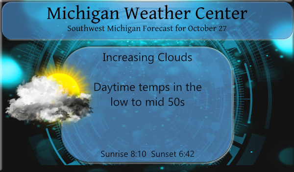
Yesterday we enjoyed lots of sunshine with temps in the low 50s, our low overnight is 30° at 7 am. The rest of the week will feature more clouds than sun as is usual for this time of year with our next chance of rain coming late Thursday.
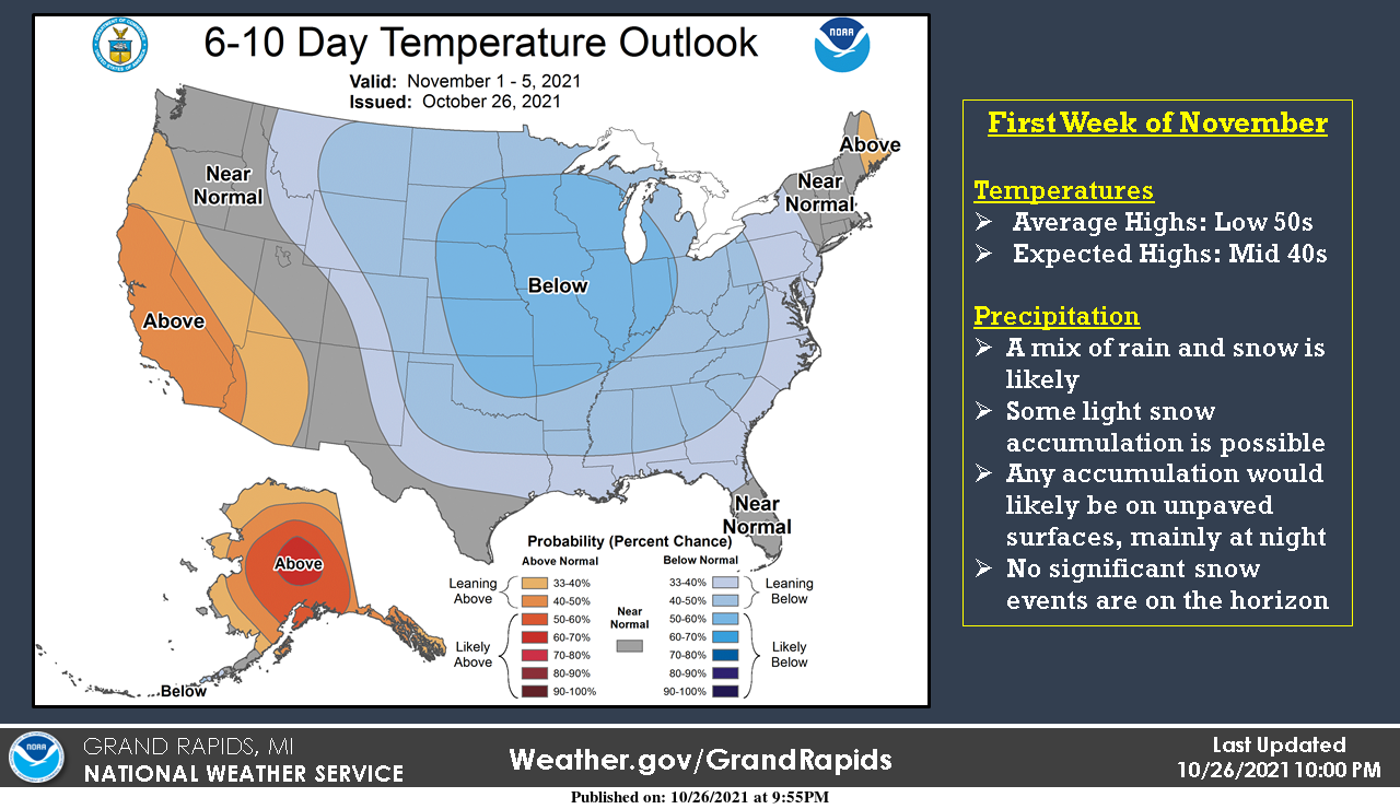
Looking ahead to the first week of November, we’ll see high temperatures settle into the mid-40s for most locations, which is about 5 to 10 degrees below normal. Scattered rain and snow showers are possible with some light snow accumulations mainly confined to unpaved surfaces at night. Nothing major on the horizon yet!
Weather History for SW Michigan
October 24
1967: A tornado injures four people as it destroys a trailer in Monterey Township, Allegan County.
2001: A squall line moves across southern Lower Michigan producing widespread wind damage and several tornadoes. The town of Schoolcraft in Kalamazoo County is hit by winds estimated up to 100 mph, causing extensive tree damage and some structural damage. The town of Marshall in Calhoun County also sustains some damage to homes as winds gust between 60 and 80 mph.
October 25
1962: Snow accumulates an inch or two across southwest Lower Michigan as an October cold snap continues. Low temperatures fall into the 20s at most locations for four straight days from the 24th to the 27th.
October 26
1869: Several inches of snow pile up across southwest Lower Michigan. The 5.5 inches at Lansing is a record for early season snowfall and the high temperature there only reaches 34 degrees.
2008: Thunderstorms combine with a cool air mass to bring some hail to Lower Michigan. Small hail covered the ground in a few locations.
October 27
1967: The heaviest October snowstorm on record strikes southwest Lower Michigan with widespread amounts greater than 6 inches. A total of 8.4 inches at Grand Rapids is almost double the amount of the next greatest October snowstorm.
October 28
1869: Michigan is in the grip of an icy cold wave. The temperature falls into the teens for eight consecutive days at Lansing, where it is the coldest October on record.
October 29
1925: October feels more like December as snow and cold prevail for much of the last half of the month. Measurable snowfalls for three consecutive days with high temperatures at or near freezing from October 28th to the 30th.
October 30
1988: Record cold temperatures in the teens and lower 20s close out the month. The low of 18 degrees at Grand Rapids on this day ties the record for the coldest ever recorded in October.
Weather History for SE Michigan
October 24
On October 24, 2001, a strong cold front moved into the Great Lakes region during the early morning hours of the 25th. Ahead of this cold front, warm air surged northward into the Great Lakes. Thunderstorms developed ahead of the cold front late in the afternoon of the 24th and continued into the evening. These thunderstorms extended from the Great Lakes all the way to the deep south. Strong winds just off the surface allowed some of the thunderstorms that developed across southern Michigan to become severe. Most of the severe storms caused damaging winds gusts with a few hail reports. Most of the wind gusts were estimated between 60 and 70 mph, but isolated locations in Lapeer County gusted up to 100 mph. Some of the thunderstorms developed rotation, a few of which produced tornadoes. Three tornadoes were spawned from the thunderstorms including an F0 near Fosters, an F1 from Hartland to Davisburg, and another F1 from near Munger to Quanicassee.
On October 24, 1991, the overnight temperature dropped to only 63 degrees in Flint, which is the daily record for the highest minimum temperature in Flint. This also happens to be the second night in a string of four nights (October 23-26) in which record high minimum temperatures were recorded!
Also on October 24, 1933, an early season snowstorm left the Saginaw area with 5 inches of snow.
October 25
On October 25, 1963, the high temperature rose to 82 degrees in Detroit and 81 degrees in Flint. Both set new records for the date that still stands today.
October 26
On October 26, 2008, a late-season severe thunderstorm moved across southern Oakland and Macomb Counties. The storm developed ahead of a cold front that ushered in much colder air. Many reports of severe hail were received. Berkley and Madison Heights reported the largest hail at one inch in diameter.
Also on October 26, 1963, the temperature rose to 81 degrees in Flint, which is the record high for the day. This marked the fourth day in a row (October 23-26) that record daily high temperatures were recorded in Flint!
October 27
On October 27, 2010, a historically deep low-pressure system tracked northeast through Minnesota and into Ontario. A tight pressure gradient over southeast Michigan led to prolonged strong westerly winds, generally in the 45 to 55 mph range, but a few gusts in the 55 to 60 mph range were observed north of M-59, blowing down dozens of trees and tree limbs within most of those counties.
On October 27, 1997, low pressure tracked northeast across Ohio late on the 26th through early morning on the 27th. Rain changed to snow over the Saginaw Valley and Flint area during the evening on the 26th, and snow continued until around daybreak on the 27th. Accumulations were mostly from 3 to 6 inches, with a maximum of 6 inches reported at Saint Charles, in Saginaw county. The combination of the heavy wet snow, and the fact that many trees had not yet lost their leaves, resulted in widespread tree damage and downed powerlines. Around 40,000 homes lost power on the 27th. Measurable snow fell as far south as the northern suburbs of Detroit.
Also on October 27, 1967, Saginaw had another early-season snowstorm that left 5 inches of snow covering the region.
October 28
On October 28, 1980, 2.9 inches of snow fell in Detroit on the 27th and 28th. This was the highest snow amount for the month of October in Detroit
Also on October 28, 1976, there was a two-day streak of record lows in Detroit. The temperature was 22 degrees on the 27th and 21 degrees on the 28th.
October 29
On October 29, 1999, record highs were set in Detroit with 77 degrees and in Flint with 75 degrees.
Also on October 29, 1906, Saginaw received 3.5 inches of snow.
October 30
On October 30, 2012, Hurricane Sandy merged with a system over the eastern United States to produce a large extratropical system capable of producing widespread strong winds across much of the northeast U.S., including Southeast Michigan. Strong northerly winds gusted to 75 mph, hurricane force, at Port Huron and to 65 mph at Port Sanilac. Elsewhere, widespread wind gusts of 45 to 55 mph led to downed power lines and minor property damage.
Also on October 30, 2004, a strong low-pressure system tracked through Lake Superior lead to high winds during the afternoon hours. Wind gusts of 60 mph lead to widespread power outages, downed trees and wires, along with some minor property damage throughout all of southeast Michigan. Utility companies reported power outages to 283,000 customers across lower Michigan, with at least half that total coming from southeast Michigan, where damage was estimated to be 3.5 million dollars
Also on October 30, 1966, the overnight temperature dropped to a freezing 19 degrees in Flint. This ties with October 21, 1974, for the record minimum temperature for the month of October in Flint.
Forecast Discussion
- Dry through Thursday morning
With a mid level ridge building in from the west into the start of
Thursday, dry conditions are predicted.   Low level moisture will
be on the increase though, so some lower clouds look likely at times.
However precipitation is not expected.  The low level flow will be
from the east and this will support the highest daytime temperatures
along and west of a Grand Rapids to Kalamazoo line.  It will be
a cold start to the day today with morning lows of the upper 20s to
low 30s.  With some sun today we should still see max temperatures
reaching 50 degrees for much of the area.  Inland locations such
as Mount Pleasant to Jackson will see the lowest max temperatures
today.

- Wet Thursday night into Friday
Overall the latest runs of the models continue to show a wet pattern
arriving by Thursday evening and persisting through Friday. The
mid level low remains south of the CWA.  A surge of moist air wraps
around the system into Lower MI as the storm passes off to the
south.  Upper level divergence increases into Friday over Southern
Lower MI.  The profiles become saturated by 00z Friday so rain should
be moving in then.  Most locations are projected to see a half inch
or less.  It does look like Lake Erie will be adding some moisture
to this system.  Thus eastern locations in our CWA like Jackson and
perhaps Lansing could end up with the most qpf in our CWA.
One trend is for the northern zones to see slightly more qpf than
previous runs.  No instability arrives so thunder is not anticipated.

- Turning colder early next week
Next week is looking quite cold for the CWA.  Persistent
northwesterly winds through Wednesday will draw down a chilly airmass
from the Canadian Prairies.   The temperature at 925 mb dips to near
or just below freezing later Tuesday or Wednesday.  All models show
this scenario so confidence on an much colder than normal pattern is
high.  With cyclonic low level flow and an airmass that becomes
marginally supportive of lake effect precipitation, it appears we
will see some bands of at least light rain showers by mid week.  The
models diverge considerably after that but the theme of colder than
normal holds in all the models.
Get ready for a wild rocking winter! It is going to awesome!
Most of the trees still have leaves on them this is one of the latest it has gotten with this many leaves on the trees. And it looks like most will have to cut the grass at least one more time. Of note there are still a lot of leaves on the trees even in the UP
Houghton area
https://www.mtu.edu/webcams/view/
and Munising area
https://www.exploremunising.com/web-cams/
Slim
Our first frost of the season this morning as well. Temp bottomed out at exactly 32 degrees, so just barely. Couple days from November, that is a very late first frost!
For what it is worth here is a winter forecast for Canada. https://globalnews.ca/news/8325067/canada-winter-forecast-2021-2022/ Of note for our area is “An early onslaught of cold and snow will be aided by the relatively mild Great Lakes. The incredible warmth earlier this fall means water temperatures are running anywhere from three to five degrees above normal. This may initially moderate the Arctic chill, but it will also create the ideal setup for lake effect snow in November and December. Like last winter, the quick start won’t last. Significant thaws are expected in January and February with above-normal rainfall. These storms will also… Read more »
The link above did not turn out here it is again
https://globalnews.ca/news/8325067/canada-winter-forecast-2021-2022/
Slim
Rain and significant thaws are always the best in January and February. Clears out all the crap on the roads and parking lots.
The official overnight low at GRR was that 31. At this time it is cloudy and 45 here.
Slim
29* out in my hood very frosty this morning did we skip the 30’s lol….INDY
I had a low of 28.8 here this morning.
Happy birthday ohhh Sherry….Wow thats pretty cold keep it coming…..INDY
Not weather-related, but I am unable to resist: East Lansing will be the center of the college football world on Saturday. ESPN GameDay, Fox Big Noon Kickoff, and Barstool Sports will all be there. Not sure when or if that has ever happened previously.
No worries Mark…easy MSU win. Just like Penn State win, and Ohio State win next month.
After going 2-5 last season, I would be pleased with 9-3 or even 8-4.
With a low of 31 I now have the first freeze of this fall season and with that the first widespread frost. So while not yet a “hard” freeze this was none the less a freeze. So far the official overnight low at GRR is also 31. At this time it is 31 here with clouds noted to the north.
Slim
Our official low here at the station this morning was 29.7
41 here when I woke up. Looks like it dropped to 34 around midnight.