We have 18° at 7 this morning as our coldest air of the season moves through the state. Our high yesterday was 37° and the low was 23° with partly to mostly sunny skies.
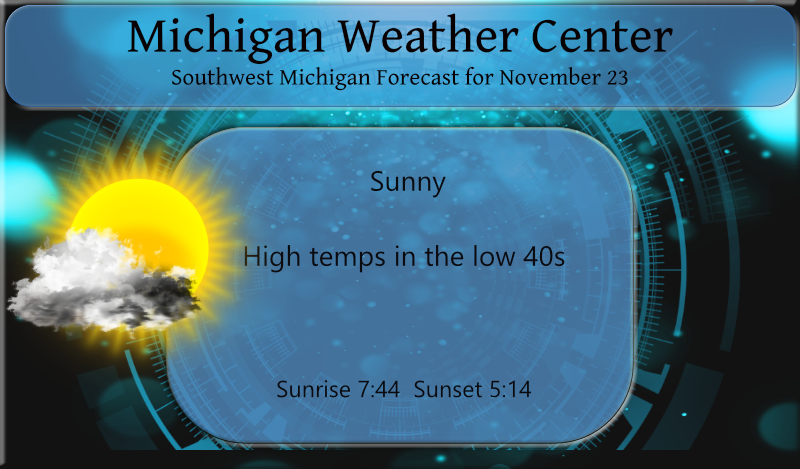
Today will feature lots of sunshine and warmer temps into the low 40s as we are in the uneventful period for the week. With the exception of some wind with an approaching cold front later today there is nothing to get excited about as will be the story for the rest of the week with the exception of small chances of rain and snow showers on Thanksgiving.
Forecast Discussion
- Burst of Stronger Winds Expected This Evening -

The decision to roll with a Wind Advisory along the lakeshore
still looks good based on the latest model runs. All of the higher
resolution models are indicating solid 40 knot gales for a 3-6
hour period on Lake Michigan. Gales of this magnitude usually
result in Wind Advisory gusts (45 mph or greater) on land.
Multiple runs of the HRRR are indicating 45 mph gusts through the
lakeshore counties at least this evening in the strong cold air
advection just behind the cold frontal passage. The cold front is
surging across Wisconsin at this time and should move into West
Central Lower Michigan up near Ludington towards 500 pm. We are
expecting the potential for some scattered power outages in the
lakeshore counties given the higher gusts there combined with many
trees closer to the warmer lake that still have leaves on them. An
isolated power outage cannot be ruled out inland. The worst of the
wind will be between 5pm and 10pm across our forecast area.

There is very limited moisture associated with this frontal
passage, so lake effect snow will be non existent to limited at
best. Visible imagery tells the story, with little in the way of
clouds upstream of our area over Wisconsin. The best cyclonic flow
will pass off to our north with the shortwave. So, if we see any
snow, the best chance for a dusting will be on the high ground up
Luther over to Tustin.

- Quiet Weather Conditions Monday through Wednesday -

A period of quieter weather is expected from Monday through
Wednesday as a dry northwest upper flow transitions into ridging
aloft. We begin warm air advecting on Tuesday as southwest flow
commences. By Tuesday evening we are too warm aloft for lake
effect snow or clouds after Delta T`s of over 20C tonight. Cannot
rule out a spotty shower on Wednesday in the afternoon, but at
this point we are thinking we will remain dry from Monday through
Wednesday. Highs on Monday in the 30s warm to around 40 on
Tuesday and to near 50 on Wednesday.

- Weather Turns a Bit More Active around Thanksgiving -

A northern plains trough will approach the area Wednesday night
and plow into the Great Lakes on Thanksgiving. The precipitation
will be of the liquid variety Wednesday night. On Thanksgiving,
the precipitation will likely be a rain changing to snow scenario.
There could be some light slushy accumulations on Thanksgiving,
especially in the afternoon and evening. Nothing that looks to
heavy, but something we will be keeping an eye on given the travel
impacts. Both the ECWMF and GFS have surface temperatures falling
below freezing during the evening. Some lake effect snow is
expected from Thursday evening into Friday before it ends.

- Disparity in the Models for Friday through Sunday -

There are differences in the models as we head into next weekend,
which is not surprising at this range in the forecast. The GFS,
ECMWF and Canadian all have the Great Lakes in an upper trough
with different handling of how shortwave energy dives into the
backside of it over our area. We will be cold enough for lake
effect snow, but the surface pattern in the three models is quite
different. We will need a bit more continuity at the surface for
sure to nail down any details.
After a chilly start, it turned into another beautiful sunny day.
14* degrees this morning in my area thats January cold in the middle of November feels great outside incredible…InDY
Incredible cold on our way to a below normal temp month! Who knew?
Another wind event today? Might as well haul the generator right back out again as I’m sure more trees will come down. Nice to see another sunny November day. Don’t usually get many of them.
By far last night was the coldest night of the season so far. The overnight low here at my house was 15 the official overnight low at GRR looks to have been 18. With clear skies the current temperature here in my yard is 16 (15.8). For the month the mean at Grand Rapids is now at 40.8 and that is a departure of -0.7.
Slim