We have enjoyed a long summer with warm temps and lots of dry and sunny days. The autumnal equinox begins this week on the 22nd and our weather pattern will cooperate with temps dropping into the 60s, which after sweltering in the 80s for so long this will feel cold to some.
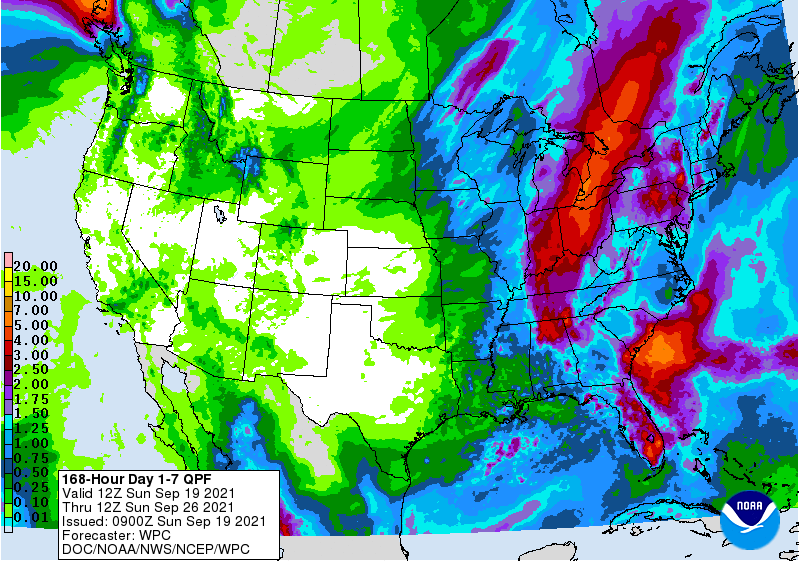
This is the seven-day QPF (rain) forecast for this week which is guessing one to three inches. We have had only .16 of rain here in Otsego thus far for September so this will be welcome. I am building a shed in my back yard so I hope to get a roof on it before the rain starts tomorrow.
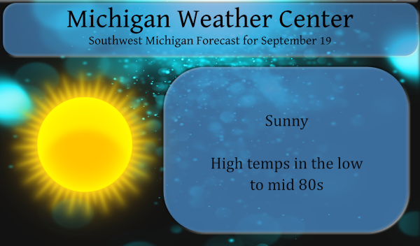
Yesterday’s high temp was 80° and the low was 61°. Today many areas in SW Michigan will see temps in the mid-80s.
Sunrise today is 7:27 and sunset is 7:45 pm.
- Swaths of heavier rain possible Monday into Tuesday

Moisture associated with the former tropical system Nicholas moves
into Southern Lower Michigan late tonight, but especially on
Monday. PWAT values will increase to right around 2.00 inches
which is rather high for mid to late September, but typical of
tropical moisture reaching this far north.

The chances for rain Monday and Monday night will be associated
with this tropical moisture and an associated upper shortwave.
There is little to focus the rainfall however with deep southerly
flow in place and no boundary to interact with. Not expecting
widespread heavy rain, but given the PWAT values there will
certainly be efficient rainfall processes ongoing.

Better chances for heavier swaths of rain are expected on Tuesday
as a cold front pushes into the very moist airmass. WPC QPF progs
show widespread 1-2 inch amounts over our entire forecast area
through Wednesday morning. Feel these amounts will likely occur in
swaths across our area and not be widespread across the entire
area. Given heavier rainfall rates some localized ponding of water
is certainly possible Monday into Tuesday. Rivers are quite low,
so not expecting much issue there. Case in point, the Grand at
Grand Rapids is at 1.61 feet at 200am which is very low.

Threat for severe weather looks low as instability never really
increases substantially. Most unstable CAPE values via the NAM3km
which has a high bias on this variable only generates around 1,000
J/KG on Monday and even less on Tuesday. Some embedded storms for
sure, but agree with the general thunder assessment via SPC.

- Chances for rain continue mid week

It appears the GFS is trending towards the ECMWF in that an upper
low retrogrades back into the Great Lakes from Ontario mid week.
This will bring additional showers to the area and think leaning
on the ECMWF is the way to go given it seems to be leading the
way. Another stronger shortwave dives into the Great Lakes late in
the week which deepens an upper trough overhead. So, showers will
likely continue into the Friday and Saturday time frame as well.
The bottom line is that we look to be set for a pattern change and
to one that is quite a bit more active than we have been seeing of
late.

- Turning much more fall like mid to late week

Temperatures will turn more towards sweat shirt weather as we head
through the work week. 850mb temps will be in the middle teens C
through Monday night as summer tries to hang on. The bottom drops
out though behind the Tuesday front with the coldest air settling
in from Wednesday and Thursday. The ECMWF actually has a Zero C
temperature over Grand Rapids at 850mb Thursday afternoon. Euro
MOS guidance has 59 for a high at GRR Thursday. We currently have
low 60s in the forecast, but could see needing to nudge this down.
Coolish weather continues into Saturday.
I have been enjoying the high pressure. Cool mornings. Warm afternoons. Dry air. It will be very warm this afternoon with the high temp 10 or more degrees above average.
I am sad to say that it looks like the end of summer is just around the corner. I am not a great fan of the cold and snow of winter and I would much preferer if it could stay warm all year long. Note I said warm not hot. But the fact is we live about half way between the north pole and the equator so we have to put up with large swings in out weather over the course of a year.
Slim
Bring on the cold front! This will put us another week closer to winter! The best season in MI! Rock n roll will never die!