
I suspect we will have an active weather pattern late this afternoon through tonight as well as an active blog as we generally have a 300% increase in traffic during stormy weather.
At this time (5 am) the core of the evening hours (4p-9p) will be the time frame of concern across Southwest Lower Michigan.
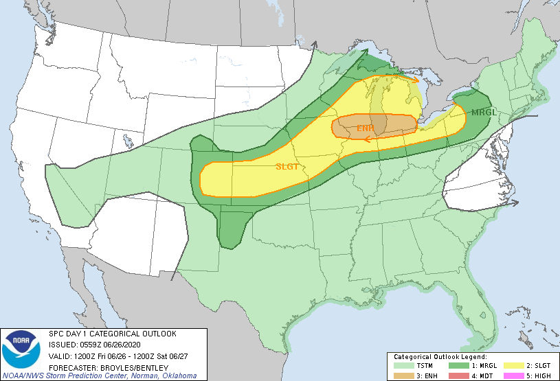
The enhanced risk now lies between I96 and I80 with the main threat being wind and heavy rain. Hail and a tornado can’t be ruled out though less likely. Some of this is dependent on how much sun we get this afternoon though at this point it appears the dynamics are in place for storms coming across the lake should hold together as they cross.
Rainfall totals could be in the one to two-inch range through the late afternoon and tonight. We will update as things change as they generally do…
A quick 1.15” of much needed rain with the first batch, although it came down so hard most of it never soaked into the ground.
It was pouring over the eave-troughs like a waterfall. The rain just rain down it never soaked in here either.
Severe thunderstorm watch until 5am
Good grief. Every weather forecast I’ve looked at for the 15 day outlook has 90 degrees and above starting Monday for 12 straight days. With 5 90 degree days already, this is going to be a very hot year. 🥵
There has been a update to the possible storms for later today. My guess it that there looks to be lower chance of severe storms. “REMNANT MID-LEVEL VORTEX FROM EARLY MORNING CONVECTION IS CURRENTLY OVER THE LAKE WEST OF HOLLAND, WITH RAIN/SHOWERS ATTEMPTING TO REDEVELOP NEAR SOUTH HAVEN AS A RESULT. WITH INSTABILITY EXPECTED TO BE FAIRLY WEAK UNTIL AFTER 3 PM, NOT EXPECTING SEVERE WEATHER UNTIL LATE AFTERNOON/EVENING. IT’S UNCERTAIN TO WHAT EXTENT THE CONVECTION IN NORTHERN ILLINOIS WILL HINDER DESTABILIZATION IN SOUTHWEST MICHIGAN OR WHETHER IT WILL EVEN MAKE IT INTO MICHIGAN GIVEN THAT IT’S TENDING TO PROPAGATE… Read more »
At this point, I’m just hoping for some rain. The last storm system that came through dumped plenty of rain just to our north and south, but we received very little.
I know it is getting rather dry.
Slim
Hoping it rains. Severe?…well, if you want to exercise “wild imagination” today, be my guest, but we already know the outcome :/
A warm and possible record-setting sunny June with plenty of storms and more heat on the way. This has been the best start to summer!
Already dropping south the enhance risk but it should be a interesting day my weather page will be very busy if everything holds together let it storm let it storm let it storm have a super but safe Friday MV’s best ….INDY
Need the rain badly, but don’t need more wind damage. The last rain we’ve had here that wasn’t a hundredth of an inch or two was over 2 weeks ago with the remnants of that tropical storm. That was the biggest storm to hit this area in many years.