
I added two new maps to the Forecast Page (bottom of page) compliments of Dark Sky – still fiddling with the code and geolocation for these. This will allow me to develop an app for this site and allow 25,000 free map loads per day for this site and 150,000 loads for Android and IOS for the app I will eventually develop. Below are the current temperature maps for Canada and Siberia. These maps can be zoomed and moved around – they also auto update.
Lots of cold air waiting to the north waiting for the jet stream to bring it down. I am seeing the guesses for the really cold arctic air hanging out in north and central Canada through the month of November.
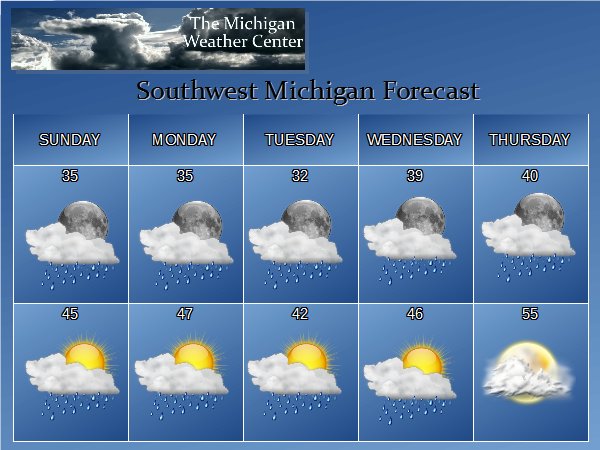
There are some hints of a snowstorm in early December but it is in my mind to early to tell for sure. As of the long range guesses I would say most of the cold and snow will hang out in the U.P. through November.
There may be a brief warm up around the 5th and 6th of next week with temperatures in the 60s then we will be back in the 50s. The models are forecasting more heavy rains for that time period.

Here is the current jet dipping to the south from east of the Rockies to east of the Great Lakes region locking the warm air over the western CONUS. There are freeze warnings from Wisconsin south to central Louisiana.
Tropical Storm Philippe is expected to become absorbed as a triple point low over the Atlantic and then lifting into southeastern Canada. Rain, heavy at times, will develop over parts of Northern New England on Monday. There are high wind warnings and flash flood watches over most of New England.
Additionally, light snow will develop over parts of the higher elevations of the Central Appalachians overnight Sunday ending on Monday morning.
Nice write up on the cold to our north, lets hope it stays there! With the 9.36” of rain that had fallen at GRR this is not only the wettest October in recorded history at Grand Rapids it is also the 6 wettest all time month as will and we are within reach of 5th place as that currently is 9.52” that fell in September of 1981. Also even with the recent cool down October mean here is still 56.9° (+5.3°) and while that will go down over the next 3 days this month will still be above average and… Read more »