
I guess we could call this a January thaw and most certainly a continuation of our boring weather pattern. Mainly Cloudy skies are expected today. There could be a few sprinkles or flurries around, not much to speak of. High temperatures today will range from 30 to 35 degrees for most locations in Southwest Lower Michigan. Colder air is on the way for the end of the week but not much in the way of snowfall.
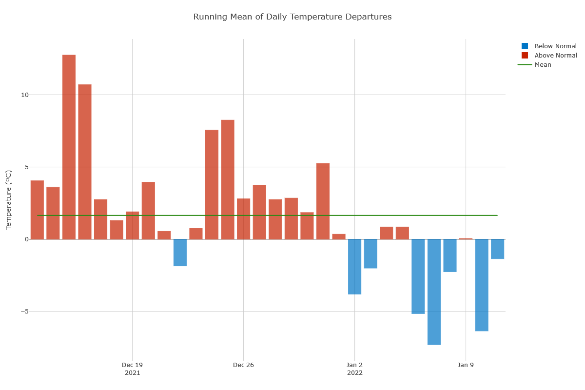
Temps have been running mainly below normal for the month of January
Yesterday we had a high of 39° and a low of 28°. Our coldest low so far for this year has been 4°.
Forecast Discussion
- Small chances for precipitation through the weekend

By January standards for Southern Lower Michigan, things are looking
relatively quiet through most of the weekend. All of the active
weather is expected to stay West and South of the state.

There is a small chance of precipitation today and tonight, but this
may be more drizzle/freezing drizzle vs. any other precipitation
type. We remain somewhat mild today, and lake effect is out of play
as a result with insufficient instability in place. We do have a
couple of short waves expected to move through. One indirect wave
comes through this morning, and then another comes through tonight.
Moisture is quite limited, so much that the DGZ is mostly not
saturated.

After some short wave ridging moves through on Friday, we see a
short wave trough drop SE through the area. This wave is actually a
piece of the energy that breaks off from the system causing the
expected storm system across the Upper Midwest to SE US. It is not a
bad wave, but the system to our W and S will limit the amount of
moisture here, and therefore the wave will bring only some mid and
high level cloud cover to the area. The Dry NE flow in the lower
levels will also eat away at any precipitation that tries to reach
the ground here.

- Window for some marginal lake effect Sunday night and Monday

The ingredients become slightly better for some potential lake
effect snow showers Sunday night and Monday. The set up remains
unfavorable for any significant lake effect at this time.

What brings a little better potential is a northern stream short
wave that moves over the area. It looks like the flow would become
cyclonic in nature late Sunday night into Monday afternoon. Even
though the wave is a little more favorable, the 850 mb temps around -
9 to -11C are barely cold enough to generate sufficient instability
over the lake which is likely around 3-4C. NW flow areas would be
the most favored to see some light accumulations before snow showers
taper off with ridging starting to build over.

- Potential for snow Late Tuesday/Wednesday

We will hold on to the upper flow from the NW into next week. The
next noteworthy feature will be a short wave that dives SE toward
the area late Tuesday into Wednesday. This could bring a widespread
light snow out ahead of the system to much of the area. The track of
the wave and corresponding sfc low are a bit uncertain this far out
yet.

What does look a bit more likely however this low comes through, is
that a fairly potent surge of cold air does look to come in the wake
of the system. 850 mb temps should drop into the -15 to -20C range.
Cyclonic flow may end up becoming established also over the region.
This would help to sustain lake effect potential over the area.
Loving the above snowfall and the
below temps is it January?? who knew?? DDDD InDY….
I suppose this is a good time to visit Miami. I am enjoying the sun and thankful for being able to travel and get time off work.
I’ll be back next Tuesday… hopefully the weather is more exciting by then. I hear a possible cold outbreak could arrive later in the month. Which seems pretty typical for Michigan that time of year.
So all that stuff out west is going to go south of us?
You got it!
To the south through the Tennessee Valley and then back up to our East. Not sure the last time a major winter storm took that route.
Yes very weird. It is weird to see all the colors out west and we aren’t going to get any… Lol. Thanks everyone!!!
I will try to put into perspective a little different as to the climate of Michigan. Here in Michigan, we are between a Continental and Temperate climate. That is because Michigan latitude is between 41°41′ N to 48°18′ N. Being on the borderline we swing between the two. The Continental have warm to cool summers and very cold winters. In the winter, this zone can experience snowstorms, strong winds, and very cold temperatures—sometimes falling below -22°F (-30°C) think areas to the north of Grand Rapids. and the Temperate zone. In this zone, there are typically warm and humid summers with… Read more »
Snow on the ground and below normal temps since December 27th love the sounds of that Winter weather woo woo. ….InDY..
Except for yesterday which was 10 degrees above average. Above today again as well.
https://forecast.weather.gov/product.php?site=grr&product=cli&issuedby=grr
It is boring. The temp has remained above freezing the past 24 hours. The streets in our neighborhood are clear and no longer an icy, chunky mess. Grass is now visible through the snow.
I kind of disagree with the definition of winter written on here yesterday. To me, it doesn’t feel like winter if it’s not cold or we’re not getting any snow. Of course, this definition is winter is strictly for those of us in West Michigan. Each region has a different definition of winter.
I understand what you’re saying. To me, winter is just one of the four season is more of a chronological thing rather than a weather thing.
The winter doldrums will continue here for the next week or so if not more. Here in Michigan we are just in the wrong place for any snow at this time. There will be snow to the west of us and a lot of snow to the east of us but not for us. The overnight low here and the official low at GRR was just 31 and at this time it is cloudy and 31 here.
Slim
Nothing on the horizon for at least another 5 or 6 days? I love it!
Wake me up when it gets interesting. ZZZ