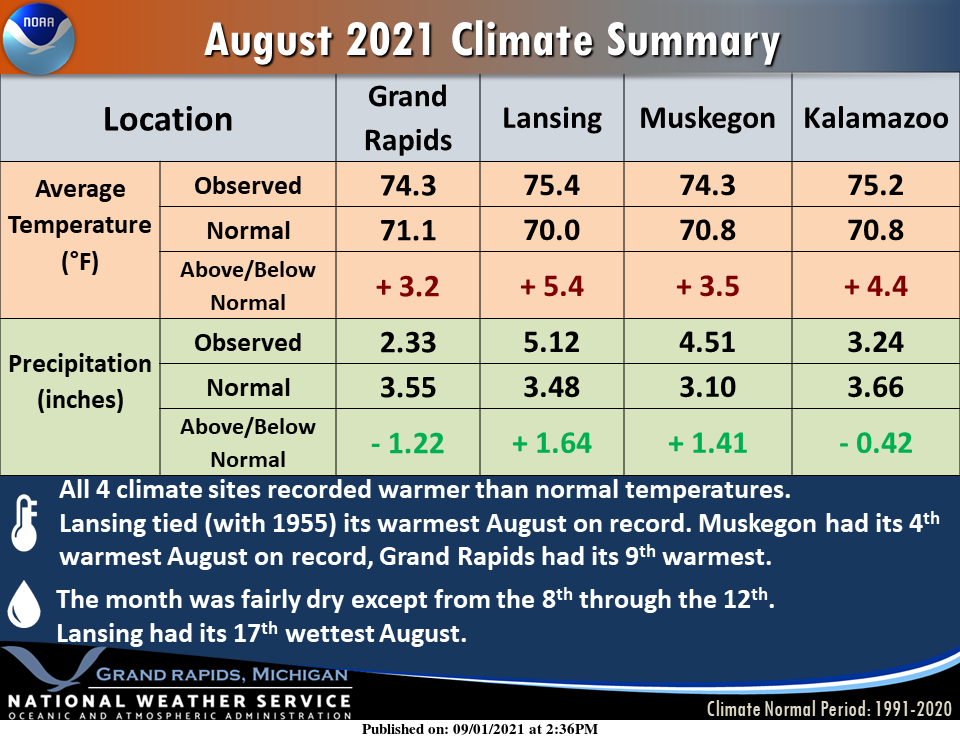
Met summer 2021 is now in the history books and we have the data from the NWS for your perusal. The info from our Gaylord and Marquette offices hasn’t been released yet. First, we have the info for August for SW Michigan and Lansing. We ended up with above-normal temps and variable rainfall across the region mainly due to hit and miss popup showers and storms
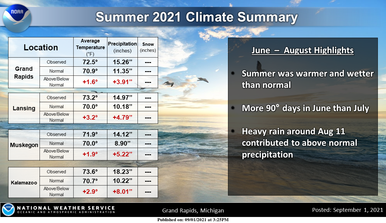
This is the summer wrapup for SW Michigan and Lansing. Once again precipitation was variable around the region. We ended up with 16.58 inches in Otsego – the largest accumulation was in June when we received nine inches.
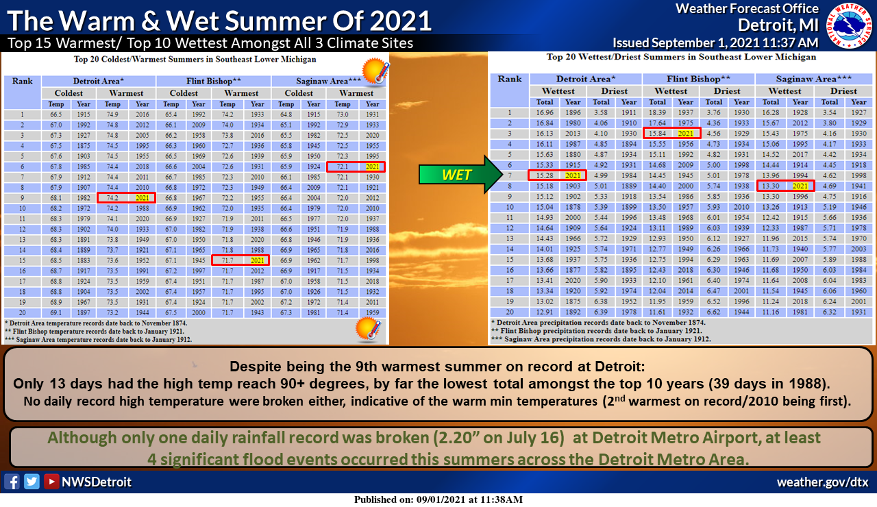
And finally, we have the data for SE Michigan for the summer:
Summer for most of the region will be remembered for dry spells which lasted a week or more throughout the season, storms and some tornadoes, and of course the heat and humidity we had in August. We now have a pleasant weather pattern to enjoy for the beginning of Met fall.
Forecast Discussion:
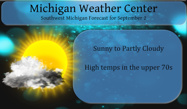
--Sunny today; clouds for Friday--

High amplitude upper ridge will provide another sunny/nice day today
before being flattened down tonight by a shortwave moving from the
Rockies toward MN/WI. This shortwave spreads considerable
cloudiness in our direction for Friday, although very dry air
below 700mb should limit precip potential to mainly virga or
sprinkles at best.

--Holiday weekend: Seasonal temps, occasional clouds/showers--

Broad upper trough over central Canada drifts slowly southeast in
our direction over the Holiday weekend, with negative height
anomalies developing for the second half of the weekend. This
pattern will certainly keep the heat/humidity in check, with
comfortable daily highs in the mid 70s and dew pts in the 50s.

As the upper trough digs south though, shortwaves within the base
of the trough should be passing through from time to time. Each
of these shortwaves, as well as any sfc troughs pivoting through
the cyclonic flow, may bring periods of clouds and a few showers.
Limiting factor however is that the air mass looks to remain
rather dry over the holiday weekend which supports mainly just
light showers if/when they occur.

At this time the best chance of showers looks to be during the day
Saturday and on Sunday night, as frontal passages are occurring.

The best potential for sunshine over the weekend will be on Sunday
and Monday when low level westerly flow off Lk MI should keep
cumulus to a minimum. Also, a sfc ridge is shown to be building
in from the west on Labor Day behind the cold front that comes
through Sunday night.

--Seasonal temps continue next week--

Another upper trough digs in behind the weekend one by the middle of
next week. A brief warm up occurs Tuesday ahead of this feature and
a band of (strong?) tstms appears possible with the cold front
passage Tuesday afternoon/evening. Behind that front we have another
installment of pleasant/seasonal temperatures flowing in.
Let’s get some frost in September last time we had some frost was in May only 3 months ago crazzy ….FALL ..INDY ..
No frost… I still have stuff growing!!!
Phew, top 10 warmest summer for Detroit! I love it!
Did GR not specify the historical rankings of their summer?
Detroit has a top 20 while but Grand Rapids does not. My guess would be that this past summer was in the top 15 or better at Grand Rapids. As far as I know Detroit is one of the few if not the only location that has a top 20.
Slim
Low of 51* degrees out in my area can we feel 40’s stay tuned ….Feels great outside!! FALL …INDY
The overnight low here was 52 (52.3) at this time it is clear and 53 (53.1) with a dew point of only 48 (47.8) There are some very cool reading in both the UP and northern lower Michigan with 40 at Cadillac and Grayling 37 at Marquette. Temperatures in the low to mid 40’s were common away from the great lakes and I am sure some smaller locations got down into the low to mid 30’s and would not be surprised that there was frost in some locations.
Slim
Sounds wintery keep the facts a coming Slim …FALL ….INDY
The difference in temp and precip between GR and Lansing for the month of August is quite remarkable – considering it is less than one hour’s drive between the two airports.
Do you know if there was a change in the location of the reporting station for Lansing? In the past Lansing seemed to have colder lows at night then they do now. That was true in both the summer and winter seasons.
Slim
Not that I am aware of. As far as I know, it has always been at Capital City Airport.
Do you know when the NWS start keeping records? I see 1875 in the Warm and Wet grid above.
Lansing has one of the longest records anywhere. It started in April 1863 but there are some years missing 1871 to 1873. One thing I noticed at Lansing is that from 1863 all the way up to 1896 it was common for lows to reach the 30’s in July and August. The record low at Lansing for August is 26 on August 29. In more recent times it has dropped into the 30’s at Lansing in 1982, 1976, 1977, 1964 and 1965. The record low at Grand Rapids (the records start in 1892) is 39 on August 30 1976 that… Read more »
Very interesting, thanks for the info. I willing to bet that the reporting station was NOT at Capital City Airport during the 19th century.
We had a low temp of 51.4 at 6 am – yesterday’s high temp was 76.
51 here this morning, as well. It was nice to be able to wear pants whilst taking the dog for a walk this morning. Picture perfect morning.