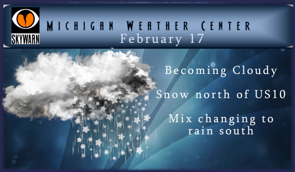
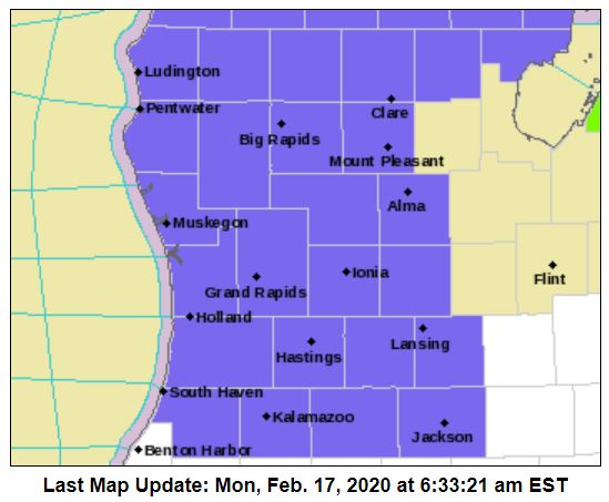
Multiple winter weather advisories (areas in blue) will be going into effect today:
Muskegon-Montcalm-Gratiot-Ottawa-Kent-Ionia-Clinton-
Including the cities of Muskegon, Greenville, Alma, Grand Haven,
Jenison, Grand Rapids, Ionia, and St. Johns

...WINTER WEATHER ADVISORY IN EFFECT FROM 5 PM THIS AFTERNOON TO
1 AM EST TUESDAY...

* WHAT...Mixed precipitation expected. Total snow accumulations
  of 1 to 3 inches and ice accumulations of a light glaze.

* WHERE...Portions of central, south central, southwest and west
  central Michigan.

* WHEN...From 5 PM this afternoon to 1 AM EST Tuesday.

* IMPACTS...Plan on slippery road conditions. The hazardous
  conditions could impact the evening commute.
Mason-Lake-Osceola-Clare-Oceana-Newaygo-Mecosta-Isabella-
Including the cities of Ludington, Baldwin, Reed City, Clare,
Hart, Fremont, Big Rapids, and Mount Pleasant

...WINTER WEATHER ADVISORY IN EFFECT FROM 7 PM THIS EVENING TO
10 AM EST TUESDAY...

* WHAT...Mixed precipitation expected. Total snow accumulations
  of 3 to 5 inches and ice accumulations of around one tenth of
  an inch.
Allegan-Barry-Eaton-Ingham-Van Buren-Kalamazoo-Calhoun-Jackson-
Including the cities of Holland, Hastings, Charlotte, Lansing,
South Haven, Kalamazoo, Battle Creek, and Jackson
335 AM EST Mon Feb 17 2020

...WINTER WEATHER ADVISORY IN EFFECT FROM 5 PM THIS AFTERNOON TO
8 PM EST THIS EVENING...

* WHAT...Snow expected. Total snow accumulations of up to one
  inch.

* WHERE...Portions of south central and southwest Michigan.

* WHEN...From 5 PM this afternoon to 8 PM EST this evening.
Leelanau-Benzie-Grand Traverse-Kalkaska-Manistee-Wexford-
Missaukee-Roscommon-Ogemaw-Iosco-Gladwin-Arenac-
Including the cities of Northport, Frankfort, Traverse City,
Kalkaska, Manistee, Cadillac, Lake City, Houghton Lake,
West Branch, Tawas City, Gladwin, and Standish

...WINTER WEATHER ADVISORY IN EFFECT FROM 7 PM THIS EVENING TO
9 AM EST TUESDAY...

* WHAT...Snow expected. Total snow accumulations of 3 to 5
  inches.

* WHERE...Portions of Northern Lower Michigan.

* WHEN...From 7 PM this evening to 9 AM EST Tuesday.

* IMPACTS...Plan on slippery road conditions. The hazardous
  conditions could impact the morning commute.

* ADDITIONAL DETAILS...Snow will spread into northern Lower
  Michigan starting late this afternoon and become heavy at times
  later this evening and overnight. Snow may mix with some rain
  overnight near Lake Michigan and toward Saginaw Bay.


Very nice storm last night! Great job NWS! Keep it up.
2 inches and counting! Nice little storm! Who would have thought!
It is a winter wonderland out there! Great winter night and still snowing! What a storm!
Right around 1 whole inch, give or take a tenth and it has stopped coming down. Looking at the radar, a huge dry slot now moving in. What a joke.
30 degrees here and just a dusting (not even measurable) at this point.
This is the second or third consecutive time where NWS GRR issued a WWA when the counties to the east of us will get the same amount of snow as us, but NWS DTX issued nothing. I am normally a proponent of the NWS, but this lack of consistency among neighboring offices makes no sense to me. Just for fun, here is the WWA criteria from NWS DTX (conveniently, GRR does not list a criteria on their website): Winter Weather Advisories for… Snow Synoptic scale storm producing snow (average forecast range) of greater than 3 inches in 6 hours, or… Read more »
Good info Mark. Looks like this “event” meets zero of the criteria.
About one inch of new snow here. Still snowing at this time with a temperature of 30°
Slim
Already one inch of snow and counting! Looking good!
Over 2 inches out at thee YARDOFBRICKS NE of GR and still snowing …INDY
Thanks NWS! I appreciate the wwa and alerting the public! Incredible!
Currently we are getting hammered with snow! Keep it coming baby!
Let it snow let it snow let snow ….INDY
Enormous dry slot in place as usual = nothing.
Wait a minute wait a minute its snowing outside again what is that now 10 days out of the last 12 with snow falling amazing…So much for very little snowfall this month a few said last week lol….INDY
Mookie says warm and no snow and we keep getting snow! I love it!
All of the teleconnectors are trending towards towards colder and snowy by the end of this month! Get ready!
The so called big warm up will not arrive until the weekend and you better enjoy it because it will be short lived and then the cold snow will be returning soon! Get ready for more snow!
The CPC shows incredible warmth the next two weeks and no cold during the next 4 weeks.
Hilarious! No cold the next 4 weeks! Fantasy land at its best! Very, very funny! I can hardly stop laughing! Thanks for the laugh!
Breaking news>>>>>currently GR is 133% above normal for February snowfall! Incredible!
And yesterday was 100% below normal for the day for snowfall.
It looks like another cold week of winter weather! Who knew? I love these long winters!
Gonna start the night off plowing parking lots and end squeegeeing them lol!! Pure michigan!!!
You know it however we will be having plenty of snow storms later this month and in March, so keep that plow ready!
What happened to us topping 50” of snow by the end of last week? We’re still a half a foot short.
There’s no accountability here. Rocky promised us 50” by last weekend for what it’s worth.
Let it snow let it snow let snow …INDY!!
Rock n roll will never die!
Thanks NWS for alerting the public! Keep it up!
So the size of a snow flake can vary a bit, but on average they are about 0.2” across. Saturday’s advisory yielded an astounding official snowfall of 0.4”, so going by average snow flake size, the snow was piled up 2 snowflakes high. Is there someone sitting by a window counting/measuring this?
The WWA for us was for 5-8pm. I don’t ever recall a three hour WWA. Now they have extended it until 1am and bumped up the snowfall forecast from 1” to 2” – which is still silly.
Yep, ridiculous. Should have been an advisory yesterday. The sun was so blinding I nearly drove into the ditch.
Here are some facts for this winter season. The first snow fall of more than a trace was way back on November 6th While November did have below average snow fall there was snow of 1” or more for 5 days that month. November at this time was the only month with below average temperatures. December was mild with most of the snow fall on the 1st and again on the 31st with not much in between. The month ended up +4.0 warmer then average with below average snow fall of 14.3”. Christmas was very warm with a high of… Read more »
Great post slim we still have a long ways to go March and April we can still get snow especially with a warm lk Michigan it takes one blast of cold air to head south into Michigan and it snows …INDY
A lot of people call it a short Winter going by what it feels like the majority of the time. 40’s, 50’s, and even 60’s in no way feels like Winter, and with the vast amount of time this season so mild, the amount of time that has felt like “Winter” has been incredibly short.
You get it Barry. For some reason, others don’t. Short winter implies very few actual winter like days, regardless of when it starts or stops in a season.
We have had 3 WWA out of the last 8 days can we say very active February like I said was coming at the beginning of the month …Great Scott more snow loving this above average snowfall month ..INDY
Keep the facts rocking despite the warm weather hype!
Last year was a long and wild winter and the GR ended up with above normal snowfall just as I predicted! I love long winters and we are headed for another one! Who would have thought?
Oh yes, especially December when we almost set the record for least snow ever and we were all golfing, or the first two thirds of January when we had about 3 tenths of an inch of snow. Forget about the record set for least amount of snow 50 days into Met Winter? Winter in name, not in the weather we had.
Thanks Barry for the reminder of the facts! Two straight week winters in a row. I love it!
We went out to Holland beach yesterday afternoon and the place was packed! Can’t say I’ve ever seen so little ice in mid February, even the piers have almost nothing on them. Lake Mac is usually peppered with fishing shanty’s, not this year. There are still large areas of open water.
Thanks NWS for doing your job and alerting the public to potentially hazardous roads! Keep up the great work!
Another WWA and more snow is in the forecast! I love it!
Facts – gr had above normal snowfall last year it was wild and long winter!
But below average for Met Winter.
Last year was below average snowfall for most locations in West Michigan. And only barely above for GR thanks to some late season snowfalls that melted within hours.
Can you believe we are 16” below last year at this time? And last year wasn’t even much of a winter.
Wow, they are just oozing desperation issuing an advisory for 3 hours for “up to 1 inch of snow”! Getting closer and closer to making it the whole Winter without a WSW (Winter Storm Not does NOT qualify).
Lolololol