We have dipped to 27° this morning. This is our first hard freeze this fall as it stayed below 28° for several hours. Yesterday we struggled to reach 44° and our low was 30° with traces of rain and snow. Today we will see much of the same as yesterday.
Weather History for SW Michigan
October 31
1917: One of the coldest Octobers on record ends on a wintry note with about an inch of snow and high temperatures only in the lower 30s.
1950: Halloween treats Lower Michigan to balmy temperatures. Grand Rapids hits 79 degrees and Lansing 77, both record highs for the date.
November 1
1950: Warm weather starts the month with temperatures around 80 degrees across Lower Michigan. Lansing sets their record high for the month of November at 81 degrees.
1976: Cold weather will rule this month across Lower Michigan. Grand Rapids sets a record low of 21 degrees to start the coldest November on record there.
November 2
1938: A record high of 77 degrees is set at Grand Rapids as a three-day spell of very warm weather begins the month.
November 3
1966: A record early season snowstorm drops 6 to 12 inches of snow across southwest Lower Michigan.
1990: Heavy fog resulted in a fatal aircraft accident near Shelby, Michigan. A private plane trying to land at the local airport in the fog stalled and crashed, killing the pilot.
November 4
2003: Heavy rains of an inch or more across southwest Lower Michigan on this day set the tone for November 2003. This turns out to be the wettest November on record at both Grand Rapids and Lansing.
November 5
1951: The temperature plunges to six degrees at Grand Rapids, a record for early season cold.
1990: Heavy rains inundate southern Lower Michigan. The 2.12 inches of rain at Muskegon makes this the wettest November day on record
November 6
1880: An early-season snowstorm strikes during one of the coldest Novembers on record in Lower Michigan. At Lansing, a foot of snow is measured on this day.
1951: Snow and cold dominate the month of November across western Lower Michigan, especially the first week. The morning low of 12 degrees at Muskegon is the fifth consecutive daily record low temperature. Lake effect snow continues piling up at a record pace with more than two feet of snow falling at Grand Rapids in the first week of November.
1975: Record warm weather prevails across Michigan with Grand Rapids and Lansing both reaching 77 degrees.
Weather History for SE Michigan
October 31
On October 31, 2013, Detroit, Flint, and Saginaw all had their wettest Halloween on record. They recorded 1.59″, 1.19″, and 1.14″ of rain respectively.
Also on October 31, 1993, was a very cold Halloween with high temperatures only reaching 43 in Detroit, 37 in Flint and 39 in Saginaw. The 37 in Flint is the record low maximum temperature for the date. During the early morning hours, snow fell and accumulated across portions of Southeast Michigan. Detroit had 0.4 inches of snow, while Flint had 0.8 inches.
Also on October 31, 1950, children experienced a warm Halloween with a record high of 79 degrees in Detroit.
November 1
On November 1, 1950, the temperature rose to 81 degrees in Detroit, 79 in Flint and 80 in Saginaw. All three cities recorded their maximum temperatures for the month of November. The Flint record would later be broken in 2015.
November 2
On November 2, 1966, the earliest snowfall of 4 inches or more occurred in Detroit with a measure of 7.8 inches of snow occurring over 3 days from the 2nd to the 5th. During this early season snowstorm Flint received 8.6 inches and Saginaw had 11.3 inches of snow. This turned out to be the snowiest November in Detroit with 11.8 inches and 2nd snowiest in Flint and Saginaw with 13.5 inches and 20.3 inches respectively.
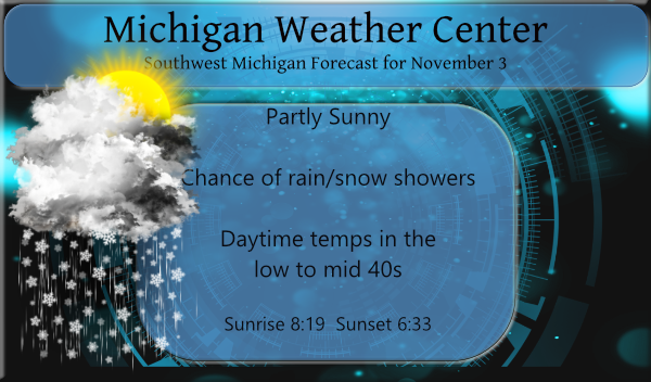
November 3
On November 3, 1951, an early cold snap on the 2nd through the 6th brought several record lows to southeast Michigan. Detroit had 22 degrees on the 2nd and 16 degrees on the 3rd. Flint had 20 degrees on the 2nd, 12 degrees on the 3rd, 14 degrees on the 5th, 13 degrees on the 6th and Saginaw had 18 degrees on the 2nd, 12 degrees on the 3rd, 16 degrees on the 4th, 12 degrees on the 5th and 14 degrees on the 6th.
November 4
On November 4, 2015, Flint set a new record for the highest November temperature on record when it reached 80 degrees. Detroit reached 77 degrees, it’s second-highest November temperature while Saginaw reached 75 degrees, it’s 3rd warmest.
November 5
On November 5, 2005, thunderstorms developed out ahead of a rapidly deepening surface low. A small bow echo took down trees and power lines across Saginaw County. This storm was responsible for cutting power to 6700 homes and one injury as a tree fell onto a man, trapping him under the branches. Pea-sized hail also accompanied this storm, blanketing the ground so thick in Merrill that it looked like snow.
Also on November 5, 1990, 2.07 inches of precipitation was recorded in the city of Saginaw. This is the highest amount of precipitation recorded in the month of November in Saginaw.
Also, on November 4, 1978, all three climate sites established new daily record highs with 76 at Detroit and Flint and 75 in Saginaw.
November 6
On November 6, 2005, Detroit reached 66 degrees while Saginaw and Flint both reached 69 degrees. This ended a stretch of unusual November warmth that included Flint reaching 80 degrees, its all-time November record, just two days prior. The average temperature of 62.2 between November 3rd and 6th made it the warmest 4 day stretch on record for November for Flint.
Also on November 6, 2005, a deep and rapidly intensifying November storm system moved North-Northeast through Southeast Lower Michigan during the morning. High winds along the associated cold front knocked down trees leading to widespread power outages. Winds were sustained out of the southwest at 30 to 40 mph with gusts as high as 60 mph from mid to late morning. The highest winds occurred between 1000 EST and 1400 EST. Many streets and roads had to be temporarily closed until trees blocking the way could be cleared. Utility companies reported approximately 200,000 customers lost power in Southeast Lower Michigan, with the majority of the outages occurring across Oakland and Wayne counties. Particularly hard hit were densely populated communities with mature trees like Detroit, Livonia, Westland, and Taylor. Property damage was estimated at 4.2 million dollars.
Also on this date in 1951, the overnight temperature dropped to 14 degrees in Saginaw, which is the record low temperature for the day. This day also marked the fifth day in a row (November 2-6) of daily record low temperatures!
Forecast Discussion
-- Scattered lake effect showers through Thursday afternoon --

A few dominant bands of lake effect snow have been pulsing in
intensity overnight. It`s still possible for a few locations west
of US-131 to receive minor accumulation on grass and cold
surfaces this morning, and right now eastern Mason into Lake
counties seem to be prime candidates aided by a moisture
connection from western Lake Superior and in the best zone of
broader confluence.

The synoptic pattern is becoming a little less favorable for lake
effect as the low levels are under increasingly anticyclonic flow
and subsidence amid a surface high building in the central
Midwest. With that and fairly dry upstream air there is plenty of
clear sky in between the lake effect bands. Despite this, thermal
profiles this afternoon still support convective mixing deep
enough for light rain or snow showers to spread farther inland
during the diurnal peak.

One final reinforcing shortwave trough will sustain lake effect
snow showers late Wednesday night into part of Thursday before
broader upper level ridging and subsidence warms the mid levels
and crushes the height of the convective cap. Some models
including the NAM maintain mid-level moisture and lift going into
Thursday evening, with a convective cloud layer between 0 and -8
Celsius so can`t rule some isolated showers lingering.

-- Milder and likely dry over the weekend and early next week --

Split upper level flow late in the week and milder air returning
on the backside of the high will give us temperatures closer to
seasonal norms and dry weather. Still can`t guarantee a completely
dry weekend, as a minority of ensemble members and the 00Z
deterministic ECMWF bring in light rain late Saturday with the
help of an ejected H500 wave from the Pac NW storm system and
attendant left exit region of an approaching jet.

Another push of warm air advection Sunday and Monday may boost
temperatures a little above normal, and dry weather is favored
until at least Tuesday. Ensembles are tilted toward mild and
occasionally wet during the latter part of next week as a synoptic
regime favoring deep mid-latitude cyclones (a la the typical
gales of November) may be setting up in the central CONUS.
Great news, all signs point towards a cold and snowy winter! Bring it on!
Talk about a cold snap! Lows in the 20’s and snow! Wow! Winter rocks!
Lots of slides offs this morning saw some salter trucks out and about also its beginning to look a lot like winter around here …DDDDDD…..ohhh had a low of 28* this morning did we skip 30’s lol….InDY
Colors on the trees are finally starting to pop around here. Probably no records kept for this sort of thing, but I can’t ever remember the trees changing this late in the year. Next thing you know the buds will be coming out already and Spring will be here.
They are beautiful!! The tree (red maple) in front of our place finally turned red today. It still has all of it’s leaves. Today when the sun shined on it it was beautiful!!
Leaves are really falling here. It got down to the mid-20s and is still below freezing currently.
Looks like temperatures rebound this weekend into next week. We shall see how late in the season we can make it without an inch of snowfall. Last year I think it was December 23.
Here the leaves are starting to drop but still a lot of leaves on the trees. As for the first 1″ of snow fall at Grand Rapids last year it was on December 24th and that is the latest on record for GR. For Grand Rapids the average date for that first 1″ snow fall is November 19th the earliest is October 12th 2006 and of course the latest is that December 24th last year. Before last year it was on December 23rd 2011.
Slim
Another beautiful sunny day if you’re not caught in lake effect.
We had a few wet flakes late in the day yesterday. Our first frost this morning with a temp of 29 (okay grass, you can stop growing now). Gorgeous waning moon this morning in the east sky.
First off I had the first snow fall of the season it mostly melted on contact. There was a total of 0.04″ of rain and melted snow here overnight. While it was the coldest night of this fall season so far it was still warmer here than at the airport. The low here was 29 while at the airport they reported a low of 25 so far. At this time it is clear here and 29 there is trace amounts of snow and ice on the roofs and cars here.
Slim