We didn’t quite make it to 90° here at the station yesterday but it was very close, we may as well say it was. We had 89.8° for the high temp with a 79.2° dew point which gave us a feels like temp of 105.5°. The .2 degrees didn’t make much difference in regards to humisery if you ask me.
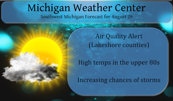
We have another air quality alert for Mason, Oceana, Muskegon, Kent, Allegan and Ottawa counties for today. Southeastern Michigan is under similar circumstances. Heat and humidity today will make it feel like the mid-90s to 100 degrees once again across most of West Michigan. Showers and storms will occasionally pass through the area, especially this afternoon and evening when a few storms could become severe.
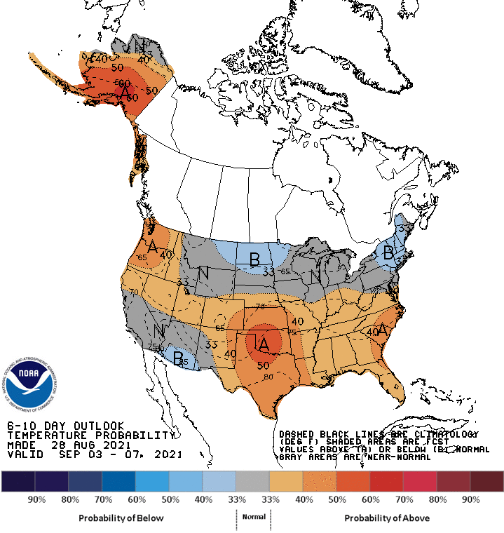
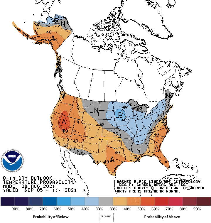
We will begin to ease out of this hot and humid airmass this week as we creep into met fall. The CPC is guessing cooler temps as we ‘fall’ into September with temps returning to normal or slightly below.
[columns] [span6]
[/span6][span6]
[/span6][/columns]
Hazardous Weather Outlook
Update 11 am
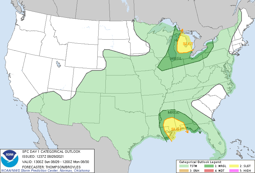
Storms still look likely across Southwest and West-Central Michigan during the afternoon and evening today, with most places seeing at least a little rain and lightning between 1 PM and 9 PM. Storms are unfortunately hard to time for specific locations right now, as we may see clusters of storms or two main lines work through. A few of these storms may become severe. Small swaths of damaging wind gusts that could knock down trees or lead to power outages are the main concern, but we could also see large hail. The area we feel the most confident in seeing a few of these stronger storms develop is north of I-96 and east of US 131.
Hurricane Ida has strengthened to a cat 4 overnight and is expected to make landfall this morning – A hurricane warning remains in effect from Intracoastal City, Louisiana, to the mouth of the Pearl River and includes Lake Pontchartrain, Lake Maurepas and New Orleans.
Forecast Discussion
-- Early Morning Storms Near/North of US 10 --

Multicellular storms over central and northern Lake Michigan
continue to be fed off abundant elevated instability and low level
moisture transport vector convergence per SPC mesoanalysis. These
storms may continue to clip our far northern/northwestern forecast
area with localized rainfall amounts of 1"-2", especially over Mason
County. Localized ponding of water on roadways is possible
overnight. These storms are forecast to lift northward and gradually
weaken, though admittedly the CAMs are failing to accurately depict
the current activity, so we will need to keep an eye on things. A
lull in precipitation is likely until the cold front moves through
this afternoon.

-- Scattered Strong Storms Today and This Evening --

Localized gusty winds and hail are the primary storm hazards today
and this evening. It appears there are a couple possible evolutions
to storm activity in association with this cold front. The 00z HREF
guidance is indicating there may be two broken lines of storms this
afternoon, one well in advance of the cold front and another along
the front itself. If this occurs it would seem the frontal
convection would be stronger and closer to the upper level
divergence that is being indicated by the models as well as
positioned closer to better deep layer shear. The other possible
evolution is there would not be a prefrontal band developing.

Deep layer shear looks better across northern Lower MI, where the
Day 1 Slight Risk has been drawn. Down our way, deep layer shear
values may not get to 30 knots, which will likely hinder the ability
of convection to develop and sustain damaging wind gusts. Thus, we
may be looking at gusty sub-severe winds that are more like 40-50
mph as opposed to 60+. Still, some pockets of power outages may
occur with these types of gusts, and isolated instances of damaging
winds to 60 mph or a bit higher may occur. The HREF suggests our
main window for thunderstorm development starts at 1pm or so and
could last until 9pm or a bit later across far southern Lower
Michigan.

-- Quiet Week Ahead until Perhaps Friday or Saturday --

The synoptic setup across the Great Lakes supports little to no
precipitation for our area until Friday or Saturday, when some
medium range guidance indicates low level moisture advection and a
shortwave riding along the south central U.S. upper level ridge. A
smattering of ECE members support some precipitation across our area
by that time, though that is pretty far out. As for temperatures
this upcoming week, much more comfortable readings will settle in to
the region with very seasonable readings in the upper 70s to around
80 degrees and lows in the 50s and 60s.
Currently 83* Degrees out in my area feels great outside …INDY
Get ready for cooler temps and much lower dew points! Summer will be winding down and before you know it we will be getting pounded with SNOW! I love it!
100% Correct So longgggg Summer ….INDY
Rock on INDT! Can’t wait till winter!
Not a drop of rain here. I watched the radar and it missed us. You can feel the air changing. It isn’t feeling as tropical as yesterday.
The breeze feels great temps falling!! Forget the heat ….INDY
No “weather” of any kind…that is all.
Very odd how a line of storms was coming at us from the West, then completely disappears as a new line forms 30 miles inland from the lake. Can someone explain that? It’s like the line warped right over Ottawa county and reappeared to the East.
Methinks it’s just rotten luck. I’m hoping to get some decent precipitation out of this line. Mowed mine and mom’s lawn today. It’s a dusty mess.
Over 90 degrees again today. That makes 7 of the last 8 days here, plus the high humidity that’s been stuck here for weeks. Has to be one of the hottest August’s in recent memory.
For most of the area it is the warmest August since 2010 One exception is Lansing were it could be the warmest on record. As of yesterday Grand Rapids mean this August is 74.2 warmest since 2010. At Muskegon this years mean is 74.3 at this time it is the 4th warmest on record and the warmest since 2010 At Holland the mean is now at 73.7 and that is the warmest since 2010. At Lansing the current mean is 75.4 and if that were to hold that would be a new record.
Slim
Updated hazardous weather outlook at 11 am
The 8 am weather report out of New Orleans Temp 80 dew point 75 winds out of the NE at 37 gust to 43. It has been windy there all night with gust as high as at least 45 MPH.
Slim
Bad news for New Orleans
https://www.cnn.com/interactive/weather/hurricane/satellite.mov?cb=27170737
🥲
A new record warmest minimum was set yesterday. The official low for August 28th at Grand Rapids was 74 and that set a new record for the date. The old record was 71 set in 1948 and 1971. For today the record high is 95 set in 1953 and the warmest low is 74 set in 1984. The overnight low here at my house was a very warm 76 the official low at Grand Rapids was 74. At this time it is 77 here with a dew point of 71 The 8 am reading at GRR was 75 with a… Read more »
So long heat and humidity as we welcome September FALL it’s the most wonderful time of year …..INDY ….
Bring it!
Phew! 92 degrees yesterday!