Yesterday we reached 51° with the sun shining all day. At the end of my post on Sunday, I said “This week will feature a more active pattern as clouds increase tonight bringing in rain or mix Monday night and Tuesday. In the second half of the week, the colder air returns with the possibility of snow. I am not overly excited about this because the temps aren’t overly Arctic in nature, just another visit from our friend from Canada.” I also shaved off most of my beard in preparation for spring. I should have put the snowthrower away and tuned up the lawn tractor – that would have fairly guaranteed a snowstorm.
I suppose I was playing down the chances of major snow this week as most of the storms have been minor this winter and I didn’t want to get hopes up of more than a couple inches of the white stuff as has been the case most of this winter. That said I still say not to take much stock in snowfall predictions and maps for the week as the tracks of any low-pressure centers aren’t guaranteed and the models are still scratching the heads. I have found it is best to take things day by day. It is good though we have a heads up and are prepared for the worse which may or may not happen.
We do know the clouds will move back in today after the nicest weekend we have had all winter giving us a taste of spring. Below is the NWS discussion from this afternoon:
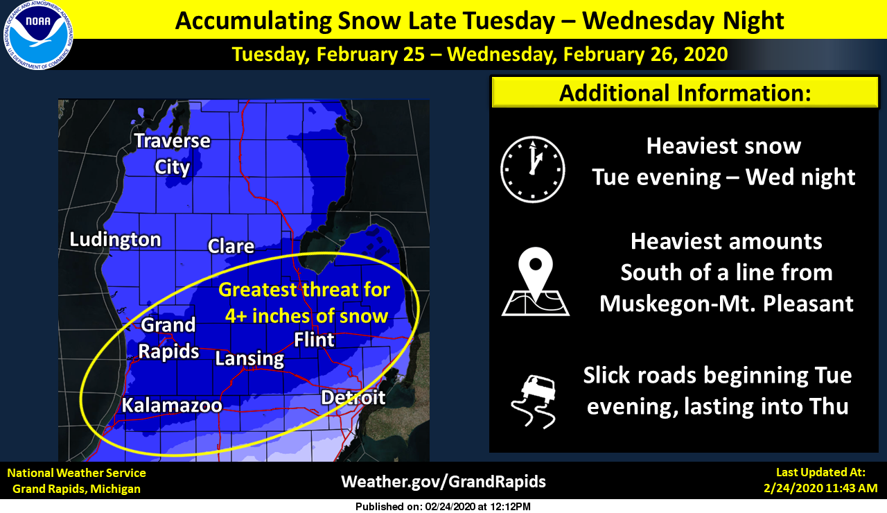
- First round of light precipitation tonight

It will take a while but the impressive dry wedge seen in the
sounding data will be eroded this evening and precip will move
north, reaching the central forecast area by 06Z. Model soundings
show that precip type should go from a mix over to snow later in
the evening as wet bulb zero heights fall through a combination of
evaporative cooling and low level cold advection.

- Steady snow arrives Tuesday afternoon into Wednesday with 4 to
  7 inches of snow expected by Wednesday evening

A sharp, narrow northern stream shortwave trough is the main
player and its amplitude and timing of its phasing with the
southern stream has been the main forecast problem that past
couple days. Fortunately, the 12Z GFS fell in line with other
models that have been consistently showing a further south axis of
the heavier snow, so we are fairly confident now in the location
and amount of snow, with the heaviest amounts coming on Wednesday
south of a line from Holland to Lansing.

Mesoscale banding in area of stronger f-gen is expected across
the southeast half of the forecast area Tuesday night and
Wednesday.

We issued a watch, though we expect snow amounts and expected
impacts should be more in line with an advisory than a warning.
Travel could be difficult as temperatures drop on Wednesday and
untreated roads become snow covered and icy.

- Lake effect snow showers on Thursday into the weekend

We expect a lull Wednesday night as the low pulls away along with
the f-gen forcing and is replaced by shortwave ridging. This is
followed by another trough with cyclonic flow and inversion
heights that would allow lake effect snow showers to form and move
inland in west northwest flow for Thursday into Saturday with some
accumulations possible.
This storm may just did it for INDY I maybe ready for a early Spring ….I cant believe the MODLE’S today …. Throwing in the towel on this Winter ….INDY
No we still have 35 days, it will come!!! Plow on!!!
Lol…like your thinking wild Bill …INDY
Agreed Indy this is the worst the models have ever done!
Breaking news>>>>>the last RDB still shows 6 to 8 inches for GR! Stay tuned for the latest updates tomorrow! The track may be moving to the North and the deformation zone will be expanding!
I have Rocky marked down for that 6 to 8 inch snow RDB prediction by Thursday morning for GR to the north, let’s see how that plays out!
Put this in your pipe and smoke it! You might as well not even look at weather models if they are going to be this far off only 1 to 2 days out! Ridiculous!
https://mobile.twitter.com/VerstegenWX/status/1232073677723832326?ref_src=twsrc%5Etfw%7Ctwcamp%5Eembeddedtimeline%7Ctwterm%5Eprofile%3AVerstegenWX%7Ctwcon%5Etimelinechrome&ref_url=http%3A%2F%2Fwww.midwestweather.org%2Fp%2Fcomputer-snow-output.html
Our local met mentioned at 6pm that the models are pushing the track to south fast. He said 6.1” for Lansing and 1.9” for GR by midnight Thursday.
What do you think we’ve been saying to you about those ridiculous instantweathermaps you’ve been posting on here for the last five years that are always about 20 times more snow than we actually get?
Still at 40 degrees here in northern Kent! Awfully warm for time of year!! BRING ON SPRING!!
0 ” – 12ft of Snow expected in the lower peninsula
Of Michigan,
Depending whos window you look out.
☃️❄❄❄❄☃️ 🤣🤣🤣🤣🤣
Funny!
Light rain and 41 here currently
1-4 inches per Bill. Nothing out of hand.. Rain next week. I love winter !
Love these long, warm, below normal snowfall winters! If every winter were like this I wouldn’t hate winter so much!
Plow trucks are tuned and ready to roll!!!! 35 days left on contracts!!! We are running out of time!!!!! I was really thinking this was gonna be the big one but now I feel the national weather service has ruined it again for us by hyping it up, we shall see, lol!!!!!!
Winter Storm Watch issued – post is updated
Amazing 3 WWA and now a WSW in the month of February that was supposed to have temps in the 40’s and very little snow at the beginning of the month forcast ….let it snow. Let it snow let it snow ….Who Knew?? INDY
That’s an average of 3.48″ per advisory/warning.
This has been a great winter month!
Sure has, I have 3 snow plow pushes 🥴🥴
I was planning on doing my grocery shopping today- I can only imagine how busy it will be with the snow coming. LOL!!
Stores are getting busy …INDY
I looked for you but didn’t see you, while I was stocking up!!! Maybe next time
Breaking alert>>>>>>>The RDB model still shows GR picking up 6 to 8 inches of snow! Get prepared now!
You wonder if we will get it. They keep saying the larger amounts of snow are moving south of us.
Winter storm watches amazing..INDY
The kids will love the snow day if we get it.
My northern Kent location is down to 1” to 3” for my NWS zone forecast! Hopefully that drops more as the storm keeps tracking further and further south!
Good news, this is exactly in line with what Slim was saying:
A sharp, narrow northern stream shortwave trough is the main player and its amplitude and timing of its phasing with the southern stream has been the main forecast problem that past couple days. Fortunately, the 12Z GFS fell in line with other models that have been consistently showing a further south axis of the heavier snow, so we are fairly confident now in the location and amount of snow, with the heaviest amounts coming on Wednesday south of a line from Holland to Lansing.
From this afternoon’s forecast discussion:
We issued a watch, though we expect snow amounts and expected
impacts should be more in line with an advisory than a warning.
That’s a headscratcher. They’re calling for 4-7″, but the last time they issued a winter storm warning, we only got 3 or so inches of snow.
Wow. Makes perfect sense? You’d think they would be embarrassed after most of the calls this Winter. Well maybe we end up with Winter Storm Not the Second?
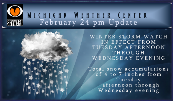
Winter Storm Watch just issued:
218 PM EST Mon Feb 24 2020
…WINTER STORM WATCH IN EFFECT FROM TUESDAY AFTERNOON THROUGH
WEDNESDAY EVENING…
* WHAT…Total snow accumulations of 4 to 7 inches from Tuesday
afternoon through Wednesday evening.
* WHERE…Portions of central, south central, southwest and west
central Michigan.
* WHEN…From Tuesday afternoon through Wednesday evening.
* IMPACTS…Travel will be difficult, especially on Wednesday when
temperatures drop and untreated roads become icy and snow
covered.
Thanks for the update not seeing anything with the word rain in it that clear up some comments on here ….INDY
Interesting stat Bill posted. The past 3 days had 100% sun. Hasn’t happened since May 2014. That sounds ridiculous!
Would not be surprised at all if we just get another weak rain event. Been the long term trend we’ve been in this entire Winter. All the cold and snow hype in the world combined with endless posts of incoming snow storms just won’t make it happen. Like Slim said, maybe next year!
…What more snow coming in February ???? No way ….INDY
Trends are for maybe less then earlier will have to wait and see. At this time I will be going for a walk outside and enjoying the rather nice mild day we are having at this time.
Slim
This weeks weather “system” has now trended weaker and further SE so any snow now may miss much of the Grand Rapids area to the SE. With the mild temperatures one has to wonder if this will be more of a rain event but we shall see. As a old baseball saying goes for all the snow lovers here in west Michigan “wait until next year”
Slim
Weaker?? What models you looking at Slim? INDY
which ones are you looking at? Today’s trends are SE and weaker that may change but that is as of now.
Slim
I’m thinking GR will get a good amount of snow I believe we are under a winter storm watch or one is coming soon..INDY
Get ready for another cold week with plenty of snow chances! We will have great winter sports conditions for days on end this week into the weekend! I absolutely love it!
Except the fact that today temps are currently in the 40’s with zero snow on the ground.
Haha exactly! And that this winter has been a scorcher with very little snow!
I would not describe any winter here in Michigan a “scorcher” but this winter will be much milder then average, with a lot less snow fall in many parts of the state.
Slim
Breaking! February will end up with above normal snowfall despite the warm weather hype! Incredible!
While warmer than average this February will be the coldest month of the winter of 2019/2020. At this time GRR total snow fall is at 13.9″ and the average for a 28 days month is 14.8″ and the average for a 29 day month is 15.2″ so it looks like there will be a good chance of this February being both above average in temperatures and snow fall.
Slim
Incredible! How is that possible? I have been telling the warm weather fanatics that you can above normal temps in the winter and above snowfall during the same period!
So much cold and snow hype when we just had a sunny mild weekend with no snow! Will we be inched to death again this week? All signs show spring building for good after that!
While there have been big snow storms in late February into March they are very rare. In recorded history only 3 times in March have there been snow storms of over 10 inches and one time in April. The the years were 2002, 1970 and 1904 for March and April in 1961. None in the last 10 days of February.
Slim
Now for spring like weather. The 30 year average at Grand Rapids for the first 60° day is March 7th the range is from January 4th in 1997 to April 15th in 2013. And for the first 65° day the average is March 24th with a range of February 11th in 1999 to April 24th in 1993. So yes I think there is a very good chance that Grand Rapids will see spring like weather in the next 30 days or so.
Slim
The GFS model has done a horrendous job with the pending storm. A day or 2 ago it had the storm way off to our North and the other models had it more to the south! Now just 2 model runs later and it takes it way south! Horrendous job with the dynamics! It will change every run for this point forward until tomorrow afternoon/evening! Accuweahter has GR in the 6 to 12 range! That is bad because the are usually way off, so we may only get a 2 to 4 inches? Stay tuned for later updates from the… Read more »
The trend today has been SE and weaker. So yes much of the GR area may not much snow out of this system. Remember the models just try to guess what might happen they do not make it happen. I am still waiting to see how today’s models handle a major 1978 type storm. Looks like I might have to wait a long time before that happens.
Slim
Garbage in = garbage out! The gfs model has been horrible most of this winter and this after the so-called software update to make it better!
At this time it is cloudy here and still a mild 43 here at my house. As far as this weeks system? Well as has been the case for a long time the different models seem to be all over the place. While there are Winter Storm Watches off to our SW and there is a chance that one will be issued for our area later today (or not) at this time I would take this with a grain of salt as there have been several WWA for just small amounts of snow and one can not forget this winters… Read more »
Nice looking map and it may continue to get better! Who would have thought?
This storm system may intensify right over West MI with heavy snow! The warm weather fanatics better get their snow blowers ready for action! I love it!
Idiots. 50 degrees out and people are STILL falling through the ice. How dumb can they be???
https://www.woodtv.com/news/southwest-michigan/2-fishermen-rescued-after-falling-in-lake-in-branch-co/
Check out the NAM!
http://wxcaster.com/gis-snow-overlays2.php?STATIONID=GRR
Get out and enjoy winter this week! This weekend will be another ideal weekend for outdoor winter sports! Incredible winter so far! Another long winter – started the beginning of November and now rocking as we head into March! Incredible!
Yes, we enjoyed Winter yesterday. Went for a long walk and it was 50 degrees out. Just perfect for February!
Going to be a quick melt down of any snow we might get according to Bill:
“ warming temperatures for the start of March, with both the GFS and the European models taking Grand Rapids into the 50s around March 3-4.”
>>>>>>BREAKING a WEATHER ALERT>>>>>great track for heavy snow in the GR area! The latest 6Z RDB model gives GR 6 to 10 inches of snow! Get ready now!
IWS says 10-14 inches of snow GR to the North ….BIG DADDY SNOWSTORM INDY
That is very possible as the dynamics and still coming together and someone will be picking up over a foot of snow! The exact location is still in play, however the GR area may be in a good spot! Stay tuned!
The overnight run of the major MODLES are off the charts with snow amounts BIG DADDY not out of the question…INDY
GFS shows us getting pounded with snow something is brewing we can’t forget the wind ….lots of school closings coming Wednesday….Let it snow let it snow let it snow …INDY
It is definitely brewing, even though many on here keep talking about no snow or cold! Incredible!
Wow did you see the 20*s the rest of the week incredible…..INDY
Oh yes, this will be another great week of winter weather! I love these long winters!!
Warm Spring weather is a long ways off! It looks like another great week of winter weather! Bring it!
http://wxcaster.com/gis-gfs-snow-overlays2.php?STATIONID=GRR