Which Common First Indicator Signals Bad Weather Approaching?
You’ll most often notice falling barometric pressure as the earliest and most reliable sign that bad weather is approaching.
Along with this, you might see dark clouds rapidly forming, experience sudden wind shifts, or feel temperature drops.
These signs together help you prepare and stay safe.
While cloud appearance is useful, combining it with pressure changes and wind behavior gives you the best early warning.
Keep going to discover how these indicators work and what actions to take when storms loom.
Understanding Dark Clouds as Weather Indicators
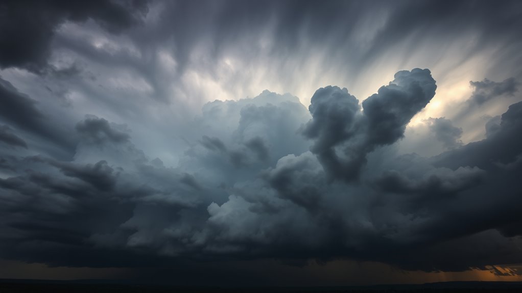
When you see dark clouds gathering, especially those thick and low-hanging, it usually means bad weather is on its way.
These dark clouds act as a clear indicator of weather changes, signaling that rain or storms could be imminent.
While not every dark cloud guarantees severe weather, their presence raises the chance of shifting conditions.
You’ll often notice cumulonimbus clouds, which are dense and towering, as a reliable sign of approaching thunderstorms.
Paying attention to these dark clouds helps you prepare for potential weather shifts.
Formation Process of Dark Clouds
You’ll notice dark clouds form when warm, moist air rises and cools, turning water vapor into tiny droplets.
These droplets group into clouds like cumulonimbus, which often bring storms.
As they thicken and darken, you can expect rain or thunderstorms to follow.
Warm Moist Air
Because warm, moist air rises and cools, it triggers condensation that forms dark clouds.
When you notice this warm moist air gathering, it means the atmosphere is unstable, setting the stage for storm development.
These dark clouds, especially cumulonimbus types, signal that significant moisture is present.
As the warm air ascends, it creates conditions ripe for thunderstorms.
You’ll often see these clouds darken and thicken as humidity rises and temperatures increase.
This process is a common early sign that bad weather is on its way.
Condensation Formation
As warm, moist air rises and cools to its dew point, water vapor condenses into tiny droplets or ice crystals, forming the dark clouds you see gathering.
This condensation happens when water vapor clings to tiny particles like dust or pollen, which act as nuclei for droplet formation.
As more vapor condenses, these droplets cluster, making the clouds thicker and darker.
You’ll notice these dark clouds growing heavier and more ominous, signaling active condensation and an increased chance of rain or storms.
Recognizing this process helps you understand why dark clouds often appear just before bad weather.
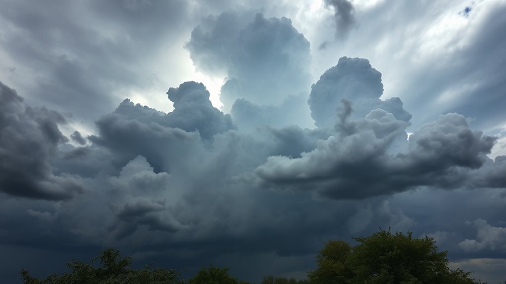
Storm Cloud Types
When warm, moist air rises and cools, it triggers the formation of dark clouds like cumulonimbus, which you’ll often see before storms.
These storm cloud types develop as air loses moisture, creating dense, towering structures that signal severe weather.
Recognizing these dark clouds helps you anticipate heavy rain or thunderstorms.
| Cloud Type | Appearance | Weather Significance |
|---|---|---|
| Cumulonimbus | Thick, towering | Thunderstorms, heavy rain |
| Nimbostratus | Dense, low-hanging | Continuous rain |
| Stratocumulus | Dark, patchy layers | Overcast, light precipitation |
Understanding these storm cloud types improves your ability to spot bad weather early.
This gives you time to prepare.
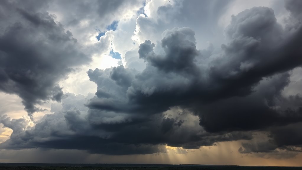
Visual Characteristics of Approaching Storm Clouds
If you spot dark, dense clouds hanging low in the sky, especially thick cumulonimbus formations, you should pay close attention.
These dark clouds form when warm, moist air rises and cools, causing condensation that creates their dense, heavy appearance.
The formation of dark clouds often blocks sunlight, casting a gloomy, overcast mood.
Their thickness and low altitude make them unmistakable signs that bad weather is near.
When you see these dark clouds rapidly developing, it usually means a storm is just minutes away.
Recognizing these visual characteristics helps you prepare for rain, thunderstorms, or even severe weather conditions.
Other Early Signs of Changing Weather
Dark, heavy clouds are one of the clearest signs that bad weather is on its way, but they’re not the only clues you can watch for.
You might notice shifting winds, especially changes in direction, signaling an approaching storm.
A sudden drop in wind speed can also hint at upcoming weather changes.
Keep an eye on the water’s surface—when it turns glassy and smooth, a storm could be near.
Fog development is another early warning, indicating atmospheric instability.
Additionally, rapid temperature fluctuations often precede severe weather events.
The Role of Wind and Temperature Shifts
Because wind and temperature shifts often precede storms, paying close attention to these changes can give you a valuable early warning.
When you notice a sudden change in wind direction—especially if it shifts from calm to strong—it’s often a sign that bad weather is on its way.
Increasing wind speed from the west is another key indicator of an approaching weather system.
Along with wind, rapid drops in temperature frequently signal thunderstorms or severe weather.
By monitoring both wind and temperature patterns consistently, you’ll improve your ability to predict and respond to changing conditions.
Together, these shifts serve as reliable, early indicators that you shouldn’t ignore if you want to stay prepared for bad weather.
Using Barometric Pressure to Predict Weather
You can spot changing weather by watching barometric pressure with a barometer.
When pressure drops quickly, bad weather like storms might be on its way.
Paying attention to these trends helps you predict what’s coming next.
Understanding Barometric Pressure
When barometric pressure drops, it often signals that bad weather like storms or rain is on its way. Understanding barometric pressure helps you anticipate these changes before you see them.
You measure barometric pressure in inches of mercury (inHg) or hectopascals (hPa). A sudden fall in barometric pressure means the atmosphere is becoming unstable, hinting at approaching bad weather.
By tracking these shifts, you can prepare for what’s coming.
Here’s what to keep in mind about barometric pressure and weather:
- Falling pressure indicates storms or rain approaching.
- Rising pressure suggests stable, improving weather.
- Rapid drops warn of imminent storms.
- Measurements help predict weather trends early.
- Monitoring pressure changes beats waiting for visual cues.
Knowing this lets you stay ahead of the weather.
Pressure Trends and Weather
Although barometric pressure changes might seem subtle, tracking these trends gives you a clear edge in predicting short-term weather shifts.
When you monitor pressure trends, a falling barometric pressure typically signals that bad weather like storms or rain is on its way.
Conversely, rising barometric pressure usually means the weather is clearing up and conditions are improving.
Paying close attention to how quickly barometric pressure drops can be especially helpful—rapid decreases often warn you that severe weather is imminent.
Using a barometer, you can track these pressure trends over time to anticipate changes more accurately.
Using Barometric Data
Tracking barometric pressure changes gives valuable clues for predicting the weather ahead.
When you monitor barometric pressure closely, you can anticipate shifts before they appear in weather forecasts.
Here’s what to watch for:
- A falling barometric pressure often signals storms or rain approaching.
- Rising pressure usually means the weather will improve and stay stable.
- Sudden drops frequently indicate thunderstorms or severe weather.
- Consistent low or decreasing pressure suggests worsening conditions.
- Tracking pressure trends helps you prepare for short-term weather changes.
How to Monitor Weather While Boating
Because weather conditions can change rapidly on the water, you need to stay vigilant by observing the sky for dark clouds, lightning, and shifting cloud formations.
Keep an eye on these visual clues as they often signal worsening weather conditions.
Alongside visual checks, monitor barometric pressure—if it’s falling, bad weather might be on its way.
Notice any sudden shifts in wind direction or temperature, as these changes often precede storms.
Equip yourself with a VHF-FM NOAA Weather Radio or a reliable weather app to get real-time updates while boating.
Also, watch other boaters’ behavior and natural indicators like waves or spray.
Combining these methods helps you stay ahead of unexpected weather and ensures a safer boating experience.
Actions to Take When Dark Clouds Appear
When dark clouds appear on the horizon, you should immediately prepare for deteriorating weather conditions.
These ominous clouds signal rising moisture and potential storms.
As the weather turns bad, take swift action to stay safe and minimize risks.
Here’s what you should do:
- Seek shelter indoors or in a sturdy structure.
- Secure loose outdoor items that could be blown away.
- Monitor weather updates through a reliable source.
- Avoid water activities or open fields to reduce exposure.
- Inform others nearby about the approaching bad weather.
Dark clouds, especially cumulonimbus types, often precede rain or thunderstorms.
Recognizing and reacting quickly to these signs lets you stay ahead when the weather turns bad, ensuring your safety and peace of mind.
Limitations of Relying Solely on Cloud Observation
Although dark clouds often hint at bad weather, you can’t rely on them alone to predict storms accurately.
Clouds might look threatening but sometimes dissipate without causing any weather changes.
You could miss sudden weather shifts when the sky seems clear or only partly cloudy.
Relying solely on cloud observation increases the risk of false alarms or overlooking real dangers.
To get a clearer picture, you need to contemplate other environmental signs like wind changes and barometric pressure.
Combining these clues with official weather forecasts gives you the best chance to stay safe.
So, while clouds provide useful hints, don’t depend on them exclusively for weather predictions.
Use them as one part of a broader strategy for spotting bad weather.
Frequently Asked Questions
What Is a Common First Indicator of Bad Weather Approaching?
You’ll notice dark clouds gathering first, signaling bad weather.
They look thick, dense, and block sunlight, making the sky gloomy.
When you see this, it usually means a storm or rain is on its way.
What Are the Signs of Bad Weather Approaching?
You’ll notice dark, heavy clouds gathering just as you’re about to head out—that’s a classic sign bad weather’s coming.
You might also feel a sudden drop in temperature or see gusty winds picking up.
What Is an Indicator of an Approaching Storm?
You’ll notice dark, dense clouds gathering low in the sky—
that’s a clear indicator of an approaching storm.
They block sunlight and signal rain or thunderstorms,
so keep an eye on them to prepare for bad weather.
What Is an Indicator of Bad Weather Approaching on a Boat?
You’ll notice dark, thick clouds gathering and the wind shifting suddenly when bad weather’s approaching on a boat.
Keep an eye on the barometer dropping and listen for distant thunder to stay safe out there.
Conclusion
When you spot dark clouds gathering on the horizon, imagine a storm’s shadow creeping closer, warning you to prepare.
These heavy, brooding formations often signal bad weather ahead, urging you to take action before the sky releases its fury.
While other signs like shifting winds and dropping pressure help, those ominous clouds paint the clearest picture.
Keep your eyes on the sky—they’re nature’s boldest alert, guiding you safely through changing weather.
In conclusion, dark clouds are a key first indicator of bad weather approaching.
They serve as a visual cue that something significant is on the way, urging us to stay alert and take necessary precautions.
Besides clouds, pay attention to shifting winds and changes in atmospheric pressure for a comprehensive understanding of weather patterns.
Being proactive can help you navigate through storms and ensure your safety.