
After of period of cooler than normal temps, we will return to a more summer-like pattern.
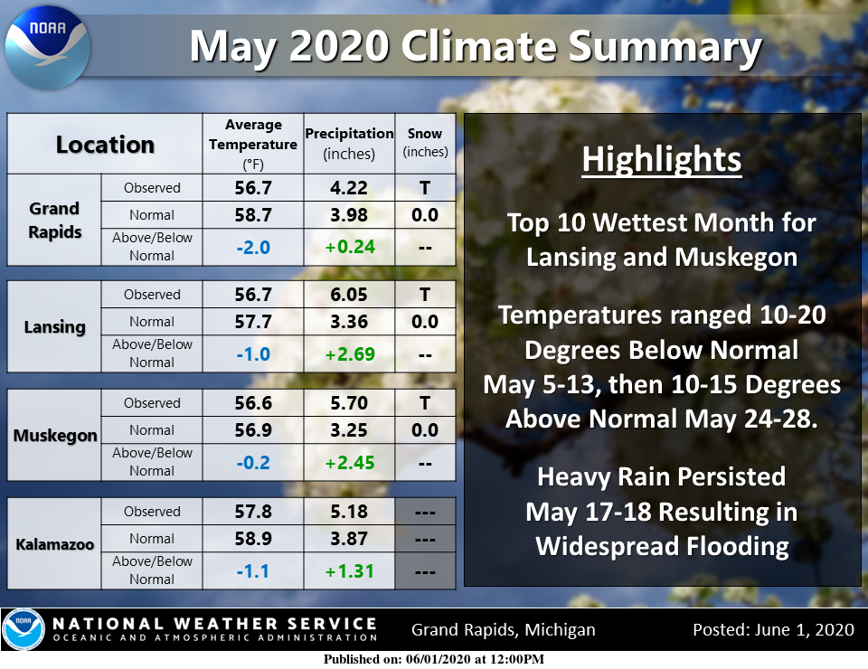
Below is the summary for May which shows we were below normal temp wise and above normal in the precip department.
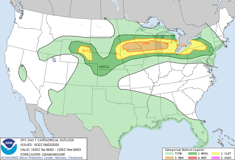
We can expect a lot of sun today with temps in the low to mid-80s. Clouds will increase this evening bringing a chance of storms overnight. Rain chances are around 60% with storms possible after 2 pm. We are in the slight risk area for severe weather with an enhanced risk to our west and north. The greatest hazards from any storms will be wind and hail.
Thunderstorms will move into Lower Michigan tonight bringing the potential for some damaging wind gusts and heavy rain. The higher chances for rain and strong winds will be between Interstate 96 and Highway 10, between midnight and 4 AM.
Thunder, lots of lightning and pouring rain here. Good old fashion thunderstorm
The calendar flips to June, and just like that it’s hot. 87 degrees out and it’s almost 8 p.m. with the dew point again nearing 70.
146 PM EDT Tue Jun 2 2020
This hazardous weather outlook is for portions of southwest Lower
Michigan.
.DAY ONE…This Afternoon and Tonight
Thunderstorms, some possibly severe with strong gusty winds, are
possible after midnight. The greatest threat area is north of
I-96.
Does anyone have the stats for meteorological Spring? And how does it compare to last year? Seems rain totals are pretty high for both years.
At Grand Rapids the mean this year was 46.5° average is 47.4° a departure of -0.9. last year the mean was 45.6. Precipitation 11.58” average is 9.70” last year 12.24”. Snow fall 5.0” average 10.1” last year 12.8” most snow on the ground 3” on March 23. Last year 6” on March 6,7 and 8th the sun was out 52% of the time. There was a reported 8 thunderstorms (remember just one lightning flash is considered a thunderstorm) The warmest reading was 90 on May 26th and the lowest was 17 on March 7th
Slim
Warmer spring than last year with below average snowfall. I’ll take it!
Thanks Slim!
https://www.spc.noaa.gov/products/outlook/day1otlk.html
I just noticed a email from Consumers about possible power outages tonight from the coming storms.
In looking at the May summary, no wonder my grass is so green. 🙂
You know there have not been that many warm days yet this year. So far Grand Rapids has recorded one day at 90. Three days in the 80’s and 11 days in the 70’s. Of the days in the 70’s 2 were in April.
Slim
Last year, we didn’t see our first 80 degree day until June 7th and we didn’t see our first 90 degree day until July. We are well ahead of that this year! Love the longer summers.
It looks like we are in store for some nice warm summer weather. I love it when there are high temperatures in the upper 70’s to low 80’s and lows in the upper 50’s to low 60’s. If I have my way that is the kind of weather we would have that all year long. But at this point I would settle for that all summer long. At this time it is sunny and 78 here at my house.
Slim
Well, after 10 warm days in a row, we saw 3 below average days. And now the heat is back on. Loving all this sun too!